
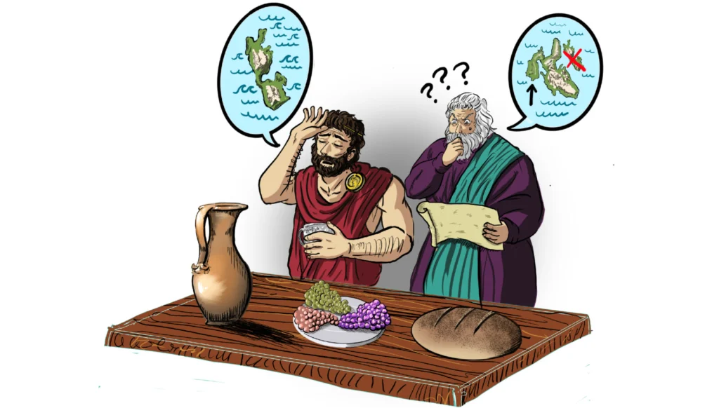
If you have ever tried to draw a geological cross-section under a fantasy map, Homer is surprisingly cooperative (and if you remember my Middle-earth geology post, you already know I live for this). The Odyssey is full of real places and real people—Troy, Mycenae, Sparta—stitched together with storms, monsters and divine interventions that would make any structural geologist reach for a stress tensor. But there is one stubborn problem in this otherwise satisfying world: Ithaca, Odysseus’ homeland, is… kind of missing.
I have a confession to make before we start: I cannot stand Odysseus. Yes, he is dramatic and clever and the Odyssey is a masterpiece, but he is also constantly crying. “Oh, you crossed the sea, sacked cities, killed thousands of people and now you cannot get home? How tragic.” The worst part is when he is finally sailing back to Ithaca and keeps stopping to tell strangers how much he has suffered—only to break down again and postpone the actual story until after someone has given him a whole cow, a couple of litres of wine, a mountain of fruit and a very comfortable bed. Maybe tomorrow, after another good cry, he will be able to explain in more detail how he killed those “people” in the country next door. He is the hero of the poem, but he is also an excellent example of a drama queen, world’s greatest overthinker.
And yes, I know it is “only” a epic poem (I did read it, I promise), but that does not change the fact that Odysseus is one of the most exhausting protagonists I have ever met. So now that I have been at least as dramatic as he is, we can get to the point: we are here for the geology (I guess).
Before we start moving faults around, a tiny bit of geography. We are in the Ionian Sea, off western Greece. Picture a little cluster of islands: big Kefalonia in the middle, long and mountainous; to its east, smaller Ithaki, steep and rugged; to its west, a lumpy peninsula called Paliki, sticking out into the open sea like Kefalonia’s tectonically confused arm. Paliki is connected to the rest of Kefalonia by a narrow, 6‑kilometre‑long strip of land called the Thinia isthmus. On modern maps, “Ithaca” is the island called Ithaki. On Homer’s map, as we will see, things are not that simple.
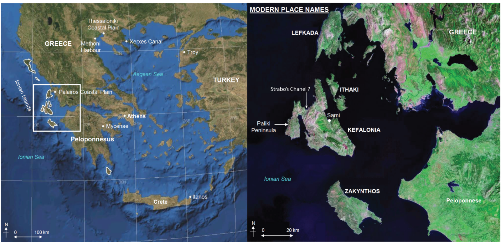
Map of the Northern Ionian Islands, edited from K. L. Hunter (2013)
Over the last two decades, this literary annoyance has turned into a full‑blown geoscience project. The “Odysseus Unbound” hypothesis proposes that Paliki was once a separate island—the real Ithaca—cut off from Kefalonia by a narrow marine channel described by the ancient geographer Strabo as “so low‑lying that it is often submerged from sea to sea”. Testing that idea has dragged an impressive arsenal of methods—gravity, resistivity, seismic refraction, helicopter‑borne electromagnetics, cores and coastal stratigraphy—into what is, at heart, an argument about a poem. In this post, we will follow that investigation across the Thinia valley and see how much geodynamics can (and cannot) say about where Odysseus (looooser) called home.
Land ho!
Remember (or let me clarify) that The Odyssey is an epic poem, not a modern novel like The Lord of the Rings. It leans heavily on repetition, formulaic phrases, extended metaphors and extravagant, evocative names to describe people, places and events—which makes it both harder and more fun to interpret geologically. When Homer describes an island, he is not writing a GPS manual; he is writing poetry. Great for literature, terrible for georeferencing (try to write a paper like that and we will see).
When Odysseus finally introduces himself to the Phaeacians in Book 9 (after a good cry, obviously), he gives one of the most argued‑over geographical descriptions in ancient literature. In most translations (I read it in Catalan, but the idea is the same), Ithaca is “bright” or “clear‑seen”, with a forested mountain (Neriton) visible from afar, surrounded by other islands—Dulichium, Same and wooded Zacynthus—while Ithaca itself “lies low” and is “the furthest towards the west, toward dusk; the others lie apart toward dawn and the sun”. It is a rugged land and a good “nurse of young men”, not a flat sandbank, but the combination of “low‑lying” and “furthest west” has become the key to every Ithaca treasure map since antiquity. Read it by yourself here:
εἴμ’ Ὀδυσεὺς Λαερτιάδης, ὃς πᾶσι δόλοισιν
ἀνθρώποισι μέλω, καί μευ κλέος οὐρανὸν ἵκει.
ναιετάω δ’ Ἰθάκην ἐυδείελον: ἐν δ’ ὄρος αὐτῇ
Νήριτον εἰνοσίφυλλον, ἀριπρεπές: ἀμφὶ δὲ νῆσοι
πολλαὶ ναιετάουσι μάλα σχεδὸν ἀλλήλῃσι,
Δουλίχιόν τε Σάμη τε καὶ ὑλήεσσα Ζάκυνθος.
αὐτὴ δὲ χθαμαλὴ πανυπερτάτη εἰν ἁλὶ κεῖται
πρὸς ζόφον, αἱ δέ τ’ ἄνευθε πρὸς ἠῶ τ’ ἠέλιόν τε,
I am Odysseus, Laertes’ son, world-famed
For stratagems: my name has reached the heavens.
Bright Ithaca is my home: it has a mountain,
Leaf-quivering Neriton, far visible.
Around are many islands, close to each other,
Doulichion and Same and wooded Zacynthos.
Ithaca itself lies low, furthest to sea.
Towards dusk; the rest, apart, face dawn and sun.
Od 9.19-26 (text from http://www.odysseus-unbound.org)
Now put that next to the real map again. Modern Ithaki, the island that has carried the name since classical times, is steep and mountainous, with high peaks that do not immediately scream “low‑lying”. In the Ionian group, it also sits to the east of Kefalonia, not at the extreme western edge. If you were an ancient sailor heading into the sunset, the land that feels “furthest towards the west” is not Ithaki at all, but Paliki on the western side of Kefalonia—except that Paliki is not an island today, but a peninsula tied on by the Thinia isthmus.
So we have a problem: either Homer was very bad at counting islands (possible, but not very satisfying), or the coastline has changed since the Late Bronze Age (more interesting), or our modern habit of slapping ancient names onto present‑day shapes is misleading us. For a long time, many scholars picked the first option and treated these contradictions as proof that Homer’s geography was essentially fictional, or at least hopelessly distorted by centuries of oral performance. That attitude began to soften after the late nineteenth‑century excavations at Hisarlık, widely accepted as the site of Troy, showed that places from the Iliad were rooted in real Bronze Age cities rather than pure invention. If Troy could be dug up with a spade (and partly destroyed in the process), then perhaps Ithaca, too, deserved the indignity of a gravity survey.
Strabo’s clue and the Odysseus Unbound hypothesis
Centuries after Homer, the geographer Strabo added a bit more mystery. Describing Kefalonia in his Geography, he mentions that “where the island is narrowest it forms an isthmus so low‑lying that it is often submerged from sea to sea”, and even locates it between the territories of Pale (on Paliki) and Cranii (on eastern Kefalonia), exactly where the Thinia valley now sits as the only land bridge between peninsula and main island. In other words, Strabo seems to remember a place on Kefalonia that behaved less like a stable ridge and more like a half‑drowned sill.
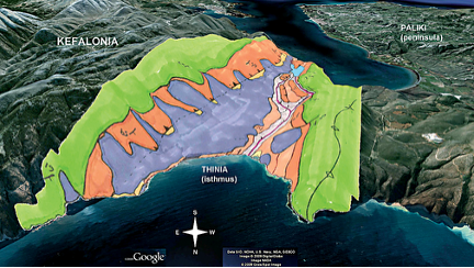
Airborne resistivity survey results over the Thinia valley.
This is the sentence that launched Odysseus Unbound Foundation to work on “The Search for Homer’s Ithaca”. In his 2005 book, Robert Bittlestone, working with philologist James Diggle and geologist John Underhill, proposed that during the Late Bronze Age and classical period Paliki was not a peninsula at all, but a separate island divided from Kefalonia by a narrow marine strait running through Thinia. In their reconstruction, repeated large earthquakes along nearby faults triggered catastrophic landslides and rockfalls from the steep limestone walls, gradually choking “Strabo’s Channel” with debris and leaving the former sea passage literally high and dry. Paliki would then have been the low‑lying, westernmost island of Homer’s description; Thinia would be the scar where a geodynamic process quietly rewrote the map while nobody was watching.
It is a wonderfully audacious idea: a classicist, annoyed by a few lines of Greek, accidentally invents a geomorphology problem and then drags half of geophysics into solving it (and me writting this).
How do you X‑ray a mythic island?
Once you decide to take Odysseus seriously—his descriptions, not necessarily his personality—Thinia turns into a list of very blurry questions:
- Was the Thinia saddle ever close to sea level in the last few thousand years, or has it been high ground for much longer?
- Is there a buried channel—a genuine “Strabo’s Channel”—hidden beneath the present valley floor?
- If there was once a seaway, how much rock and sediment would you need to move to lift it 180-200 metres above sea level, and can earthquakes and landslides realistically do that job?
Answering those questions without digging a trench across an entire Greek island requires a lot of indirect vision. The Thinia project (geological and classical research initiative focused on the Greek island of Kefalonia, primarily seeking to locate the true historical home of Homer’s Odysseus) therefore turned into a kind of geophysical forensics lab: instead of fingerprints and DNA, the team used tiny variations in gravity, electrical conductivity and seismic wave speed to sketch the shape and history of the subsurface.
Gravity and airborne electromagnetic (EM) surveys provided the first wide‑angle X‑ray. Loose valley fill—landslide debris, soils, colluvium—tends to be less dense than solid limestone bedrock, and often more conductive if it is clay‑rich or water‑saturated. By flying EM instruments over northern Paliki and measuring tiny changes in the Earth’s gravitational and electromagnetic fields, the team could estimate how thick the low‑density, conductive material beneath Thinia is and where denser bedrock rises closer to the surface. A deep, continuous trough of low‑density material might signal a former channel; a patchy, shallow infill hints at a more modest valley.
Seismic methods offered a sharper, more local picture. On land, seismic refraction profiles used controlled sources and lines of geophones to track how fast waves travelled through the subsurface: slow through loose sediments, faster through compacted marls and fastest through hard limestone. Offshore, shallow seismic reflection in the adjacent bays imaged buried erosional surfaces and palaeo‑valleys cut into older units, including a deeply incised drainage system beneath the modern Gulf of Argostoli that records how water flowed when sea level was much lower during the last glacial maximum. Together, these data show where former valleys and potential channel routes would have been, even if later sediments have partly filled them.
Finally, resistivity surveys and boreholes/cores did the unglamorous but essential “ground truthing”. Electrical resistivity measurements helped distinguish more resistive bedrock from wetter, finer‑grained sediments, while 17 shallow cores across key sites in Thinia and nearby marshes yielded actual material to look at under the microscope. Marine microfossils, algae and sedimentary structures in these cores allowed biostratigraphers to say “this was a shallow sea” or “this was a lake or wetland”, and to assign ages to those environments using established microfossil ranges. That is how you turn a poetic “isthmus often submerged from sea to sea” into a timeline of when, exactly, salt water last occupied the valley.
Put together, it really does feel like CSI: Ithaca (yeaaaaaahhhh, hope you read this like CSI opening): each method is one more piece of forensic evidence brought in to interrogate a few lines of Homer and a throwaway remark from Strabo. The surprise is that the victim on the table is not just a missing island, but also our assumptions about how fast landscapes can change on human timescales.
Building (and questioning) Strabo’s Channel
The first wave of work in Thinia seemed to play nicely with Strabo. Early geophysical soundings and boreholes found marine sediments beneath the present valley floor, including fine‑grained deposits with marine microfossils that clearly formed below sea level. In the adjacent coastal embayments, shallow seismic lines and geomorphic mapping revealed buried drainage features and palaeo‑valleys aligned with the Thinia saddle, as if a former waterway had once connected the Gulf of Argostoli in the south with the bay to the north. On the valley walls themselves, scarps and hummocky topography testified to large landslides and rockfalls cascading off the steep limestone slopes—a ready‑made mechanism for dumping huge volumes of debris into any channel that might have existed.
Zooming out, the tectonic context makes such a fragile strait seem almost over‑determined. Kefalonia sits in the outer Hellenide belt, where the African plate is colliding with Eurasia and where the Pre‑Apulian units are being shortened and uplifted along major structures like the Aenos Thrust. Just offshore, the dextral Kefalonia Transform Fault accommodates part of the relative motion between the Aegean and Adria microplates, generating frequent moderate to strong earthquakes, including the infamous 1953 sequence that produced shaking equivalent to roughly magnitude 7 and caused extensive damage across the island. This combination of active thrusting and strike‑slip faulting creates exactly what you see around Thinia: steep relief, oversteepened valley sides and a landscape primed for slope failure.
The conceptual model that emerged from these pieces is appealing in its simplicity. Start with a low‑lying marine strait at Thinia—a narrow sill just above or at sea level, perhaps already cut into relatively young marine marls. Shake it repeatedly for a few thousand years with earthquakes on the Kefalonia Transform and related faults; each major event triggers rockfalls and landslides from the canyon walls, sending blocks and debris tumbling into the channel. At the same time, long‑term regional uplift on the outer arc slowly raises the whole area, turning yesterday’s sea passage into today’s 180-200 metre high valley floor. In this picture, Strabo’s “isthmus so low‑lying that it is often submerged from sea to sea” is not poetic exaggeration, but a snapshot of a strait in the process of being choked and lifted by the combined effects of tectonics and gravity.
Poseidon’s fury: when did the sea really leave?
This is where the story stops behaving like a simple detective novel. A three‑year investigation of Thinia threw almost every available geophysical tool at the problem—helicopter‑borne EM, detailed gravity and resistivity surveys, seismic refraction on land, shallow‑marine reflection offshore, plus 17 shallow cores across the valley and nearby coastal sites. When all of these data were stitched together, the subsurface did not look like a Holocene channel casually infilled since Homer’s time. Instead, the valley fill turned out to be dominated by steeply dipping, tectonised marine sediments of Early Miocene to Early Pleistocene age, deformed and uplifted, with only relatively thin veneers of younger colluvium and landslide material on top.
In several places, bedrock cropped out close to the surface, and neither the onshore profiles or the offshore lines managed to trace the clear sides and bottom of a young, sea‑to‑sea channel at anything like present sea level. Biostratigraphic work on the cores pushed the last unequivocal marine conditions in the Thinia area back to around 1.8 million years ago, at the Gelasian-Early Pleistocene boundary, and failed to recover any younger, obviously marine sediments that would indicate a Late Quaternary strait. Taken together, these results suggest that if a through‑going channel once connected the two coasts at Thinia, it probably disappeared hundreds of thousands of years before the Late Bronze Age, not a few millennia ago.
In other words, the big plot twist is that the rocks insist on a much older, messier history than the neat picture of a Bronze Age seaway rapidly filled by historical landslides. Strabo’s low‑lying isthmus may still record some genuine geomorphic quirk, but the deeper geodynamics point to long‑term uplift and Miocene-Pleistocene tectonics, not a channel that closed just in time to annoy Odysseus (he’s annoying enought).
What geodynamics can (and cannot) do for Homer
At this point it is tempting to ask geodynamics to settle the argument once and for all: did Paliki match Homer’s Ithaca or not? The Thinia studies show very clearly what the rocks are willing to tell us, and where they fall stubbornly silent. On the “yes, we can” side, geology and geophysics can constrain when different parts of Kefalonia were above or below sea level, how quickly uplift has raised marine sediments to hundreds of metres elevation, and how much material could realistically have been moved by earthquakes, landslides and long‑term slope failure. They can rule out a Holocene sea‑to‑sea channel through Thinia with a straight face, and they can sketch a plausible tectonic history involving thrusts, normal faults and gravity‑driven deformation linking structures like the Atheras Thrust and Agia Ioanni Fault.
What they cannot do is fill in the human details. No amount of biostratigraphy can tell us whether Homer (or the poets behind “Homer”) personally set foot on Paliki, or whether “low‑lying” referred to absolute elevation, gentle relief compared to neighbouring peaks, or perhaps even to a harbour rather than the whole island. Different datasets, collected at different times and scales, also leave room for interpretation: early boreholes and seismic profiles that suggested thick landslide fill and young marine fossils beneath Thinia supported a recently infilled channel, while later, broader surveys and additional cores pointed towards an older, more tectonically controlled story. That kind of tension is normal when geology, geophysics and literary history collide; it is part of what makes this case so instructive for students on both sides of the Aegean.
The only firm conclusion, for now, is that the rocks have certainly moved. Whether Homer’s Ithaca moved with them is still up for peer review.
Better if Odysseus had never reached Ithaca
Odysseus, famously, needs ten years and a lot of divine dysfunction to get home (looooser). Geoscientists have now spent several decades trying to pin that home down on a faulted, uplifted carbonate platform in the outer Hellenides—and the end of the journey is no less ambiguous. Ithaca has become a moving target in two senses: a landscape actively reshaped by plate convergence, earthquakes and sea‑level change, and a literary place whose meaning shifts as new data arrive from boreholes and seismic profiles.
This matters for more than classical trivia. The same tools used to chase Odysseus—gravity surveys, reflection seismology, coastal cores—are the ones we use to reconstruct palaeogeography and relative sea‑level change in active margins, to assess tsunami and landslide hazards, and to understand how fast coasts can rise, fall and rearrange themselves on human timescales. The Ithaca story is a neat reminder that geoscience can meaningfully test ideas from archaeology and literature, sometimes supporting them, sometimes complicating them, and often replacing a simple answer with a better question.
And maybe the ultimate test of all these ideas would be a field trip: someone please invite me either to the premiere of a Christopher Nolan’s The Odyssey movie adaptation or, even better, to a scientific cruise around these Greek islands so we can validate everything on outcrop. I promise I will not cry as much as Odysseus. Or at least I will try, I just need as good food as him.
“Good luck to you, even so. Farewell! But if you only knew, down deep, what pains are fated to fill your cup before you reach that shore.”
Bibliography:

Homer. (2011). Odissea (J. F. Mira, Trans.; J. Cornudella, Intro.). Barcelona, Spain: Proa.

Bittlestone, R., Diggle, J., & Underhill, J. R. (2005). Odysseus unbound: The search for Homer’s Ithaca. Cambridge, UK: Cambridge University Press.

Hodges, G., Kilcoyne, D., Eddies, R., & Underhill, J. R. (2009, September). Geophysics and the search for Homer’s Ithaca. In Proceedings of SAGEEP 2009 / EAGE Near Surface Meeting, Dublin, Ireland. Retrieved June 9, 2026, from https://www.ags.org.uk/2009/12/geophysics-and-the-search-for-homers-ithaca/

Hunter, K. L. (2013). Evaluating the geological, geomorphic and geophysical evidence for the re-location of Odysseus’ homeland, “Ancient Ithaca” (Doctoral dissertation, The University of Edinburgh). Edinburgh, UK: The University of Edinburgh. http://hdl.handle.net/1842/8002

Underhill, J. R. (2009). Relocating Odysseus’ homeland. Nature Geoscience, 2(7), 455–458. https://doi.org/10.1038/ngeo562

Strabo. (n.d.). Geography (H. L. Jones, Trans.), Book 10, Chapter 2. In LacusCurtius: Into the Roman World. Retrieved June 9, 2026, from https://penelope.uchicago.edu/Thayer/E/Roman/Texts/Strabo/10B*.html

Herod, M. (2014, July 21). The search for Ithaca. GeoSphere – EGU Blogs. https://blogs.egu.eu/network/geosphere/2014/07/21/the-search-for-ithaca/

Odyssey’s end?: The search for ancient Ithaca. (2013, November 16). Smithsonian Magazine. https://www.smithsonianmag.com/history/odysseys-end-the-search-for-ancient-ithaca-112739669/

How archaeologists found the lost city of Troy. (2018, November 13). National Geographic History Magazine. https://www.nationalgeographic.com/history/history-magazine/article/the-lost-city-of-troy

Odysseus Unbound Foundation. (n.d.). Odysseus Unbound: The search for Homer’s Ithaca[Project website]. Retrieved June 9, 2026, from http://www.odysseus-unbound.org



Ruth Harris
I really enjoyed reading your post. It contained everything – geology, literature, history, and a warm sense of humor. Thank you!