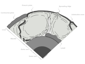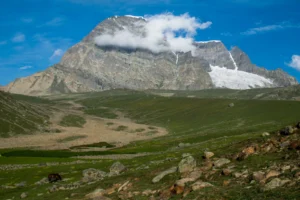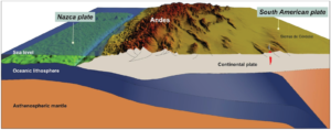
Forearc ranges are a striking example of how tectonic processes shape our planet. The Nahuelbuta Range in southern Chile is one of such settings. This week, Ambrosio Vega-Ruiz from the GFZ Helmholtz Centre for Geosciences, Germany, is telling us the story of this remarkable range, exploring how climate feedback can influence tectonic uplift across coastal forearcs.
Tectonic uplift before tectonic uplift

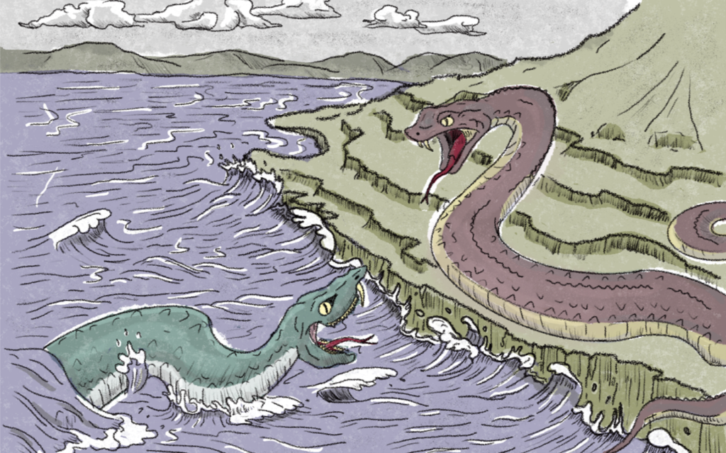
Ambrosio Joaquin Vega Ruiz (Vega-Ruiz for publishing) is a geologist born and raised in Concepcion, Chile, also formed at the Universidad de Concepcion (Concepcion, Chile). He got his PhD at Freie Universität Berlin (Berlin, Germany) in 2025 while researching about the Neotectonics along the Chilean forearc at the GFZ Helmholtz Centre for Geosciences (Potsdam, Germany). He is now a postdoctoral researcher at the Section 4.7 ‘Earth Surface Process Modeling’ of the GFZ Helmholtz Centre for Geosciences. Currently working on the Active Tectonics and Landscape Evolution of the Andean forearc along Northern Chile and Ionian Islands, Western Greece. He likes pretty much analog photography of urban and natural landscapes and portraits of his friends. He enjoys running, hiking and swimming, as well as amateur guitar playing and digital drawing (as you can see in the featured image).
Every culture has creation myths shaped by the natural forces around it. At the edge of South America, where the Pacific Ocean meets the Patagonian Andes, the Mapuche have a remarkable story about the ever-changing landscape of Chile, one that resonates with earthquake geologists and seismologists.
In the myth, Caicai Vilu, a water snake, raises the sea to flood the land, while Trentren Vilu, a land snake, lifts the ground and guides people to safety on the hills. Those who cannot escape are turned into rocky islands (featured image). The resemblance to Chile’s subduction earthquake cycle is striking: earthquakes uplift the land, tsunamis flood the coast, and over longer timescales, rising sea level reoccupies it.
I am not Mapuche, but I was born, raised, and studied geology in Concepción, Chile, just across the Nahuelbuta Range. This range is crucial to Mapuche territory and culture, but it is also a geological oddity: the highest and fastest-growing coastal mountain range in southern Chile, sitting above the rupture zone of the largest earthquake ever recorded: the M9.5 Valdivia earthquake of 1960.
That connection between landscape, culture, and geology eventually led me to study the Nahuelbuta Range in the final chapter of my PhD, exploring transient tectonic uplift in the Chilean forearc.
What are forearc ranges, and how they uplift in sediment-rich margins?
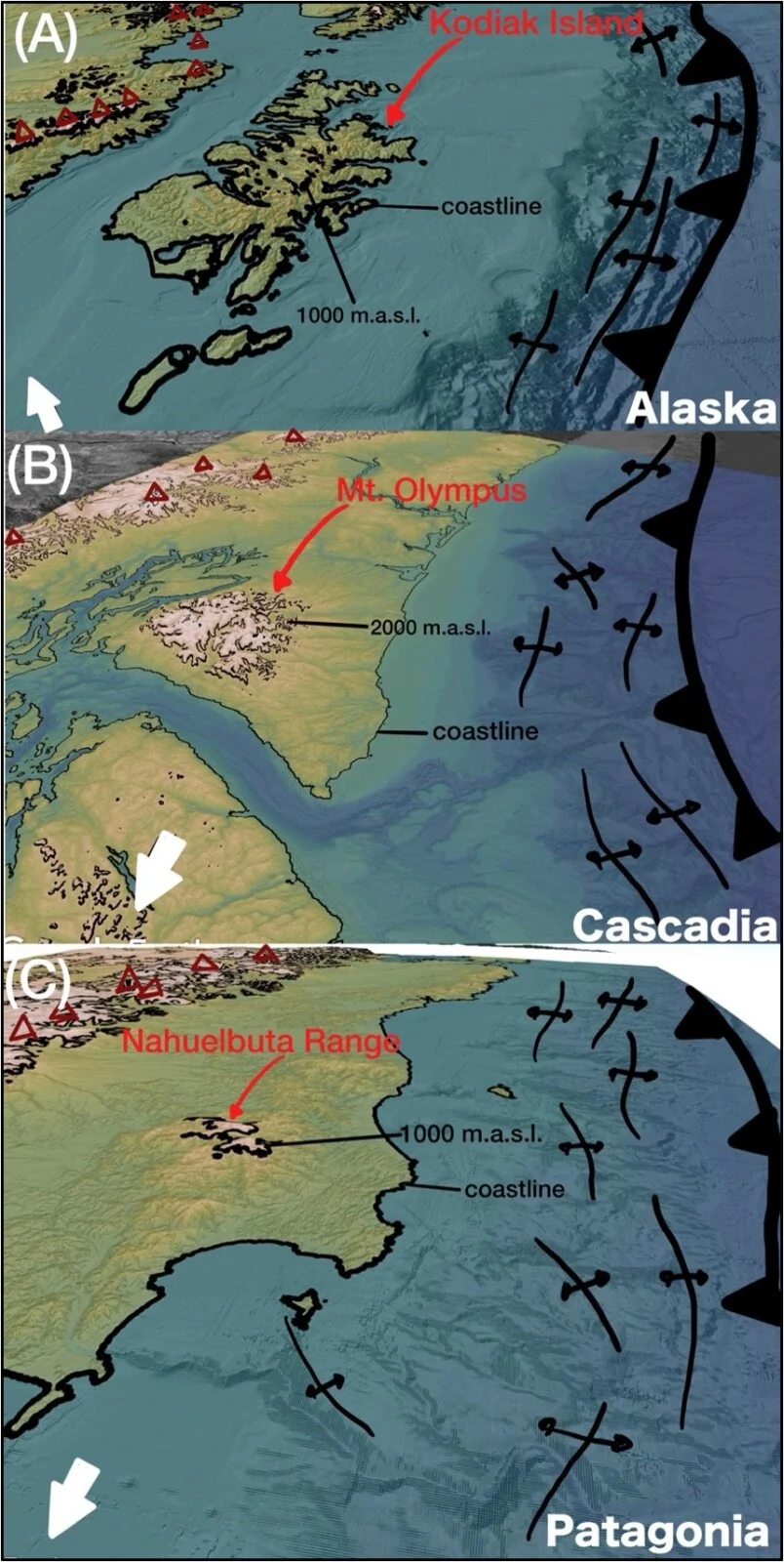
Figure 1. Examples of forearc ranges in sediment-rich margins. (A) Alaska. (B) Cascadia. (C) Patagonia. Subduction trench and folds related to frontal accretion in black. Brownish triangles indicate active volcanoes.
Forearc ranges, like the Nahuelbuta Range, are typically coastal mountain belts that form above subduction zones (Fig. 1). Their uplift is driven by several tectonic processes acting over different timescales.
At glaciated margins like southern Chile, rivers deliver huge amounts of sediment to the trench. Over hundreds of thousands (kyr) to a few million years (Myr), some of this sediment is added to the overriding plate either at the trench (frontal accretion) or beneath the continent (basal accretion) (von Huene and Scholl, 1991).
Because basal accretion happens several kilometers underground, direct evidence is rare. But recent numerical models suggest it can generate million-year pulses of uplift in coastal forearcs (Menant et al., 2020).
The Nahuelbuta Range: an unusual high in the Patagonian forearc
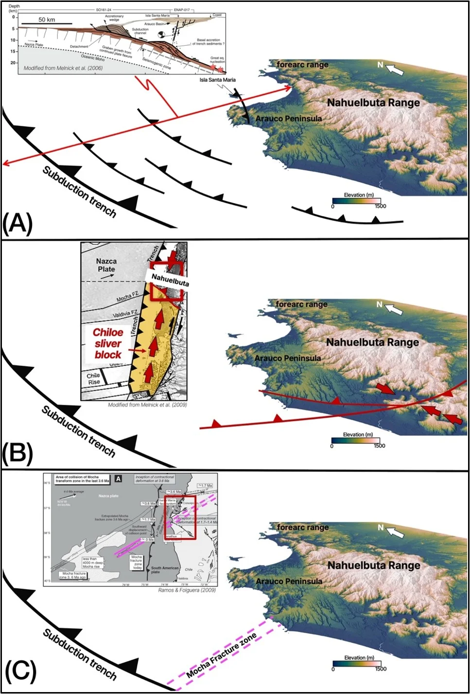
Figure 2.
(A) Accreted Late Cenozoic glacial sediments and related reverse faults. Profile modified from Melnick et al. (2006).
(B) Collision of the Chiloe microplate into the Nahuelbuta Range and related trench-perpendicular reverse faults. Inset figure modified from Melnick et al. (2009).
(C) Subduction of the Mocha Fracture Zone beneath the Arauco Peninsula and Nahuelbuta Range. Inset figure modified from Folguera and Ramos (2009).
The Nahuelbuta Range (37–39°S; Figs. 2c & 3) is a bit of a geological oddity, rising to nearly 1,500 m a.s.l., almost twice the height of the surrounding coastal mountains. Just to the west lies the Arauco Peninsula, a continental shelf that has been rising since the Plio-Quaternary (Fig. 2a).
The faults around the range are mostly compressional, reflecting both sediment accretion and the northward collision of the Chiloé block, a small crustal block moving toward the range (Fig. 2b). Another idea is that the subduction of an oceanic fracture zone also helped build the range (Fig. 2c).
The unknowns of the Nahuelbuta Range
Exactly when and how the Nahuelbuta Range began to rise is still up for debate. Some suggest uplift started between ~5.2 and ~2.8 Myr ago, linking it to the collision of the Chiloé block (Melnick et al., 2009). Others argue it began more recently, after ~1.7 Myr ago, following the subduction of the oceanic fracture zone (Folguera and Ramos, 2009). A more recent study proposed an onset at ~2.1 Myr ago through basal accretion (Encinas et al., 2021).
Marine terraces on the Arauco Peninsula can only tell us the final snapshot of the story. They record fast uplift rates of ~1.80 mm/yr over the last 300 thousand years (Melnick et al., 2009) (Fig. 3). What happened before then remains largely unknown.
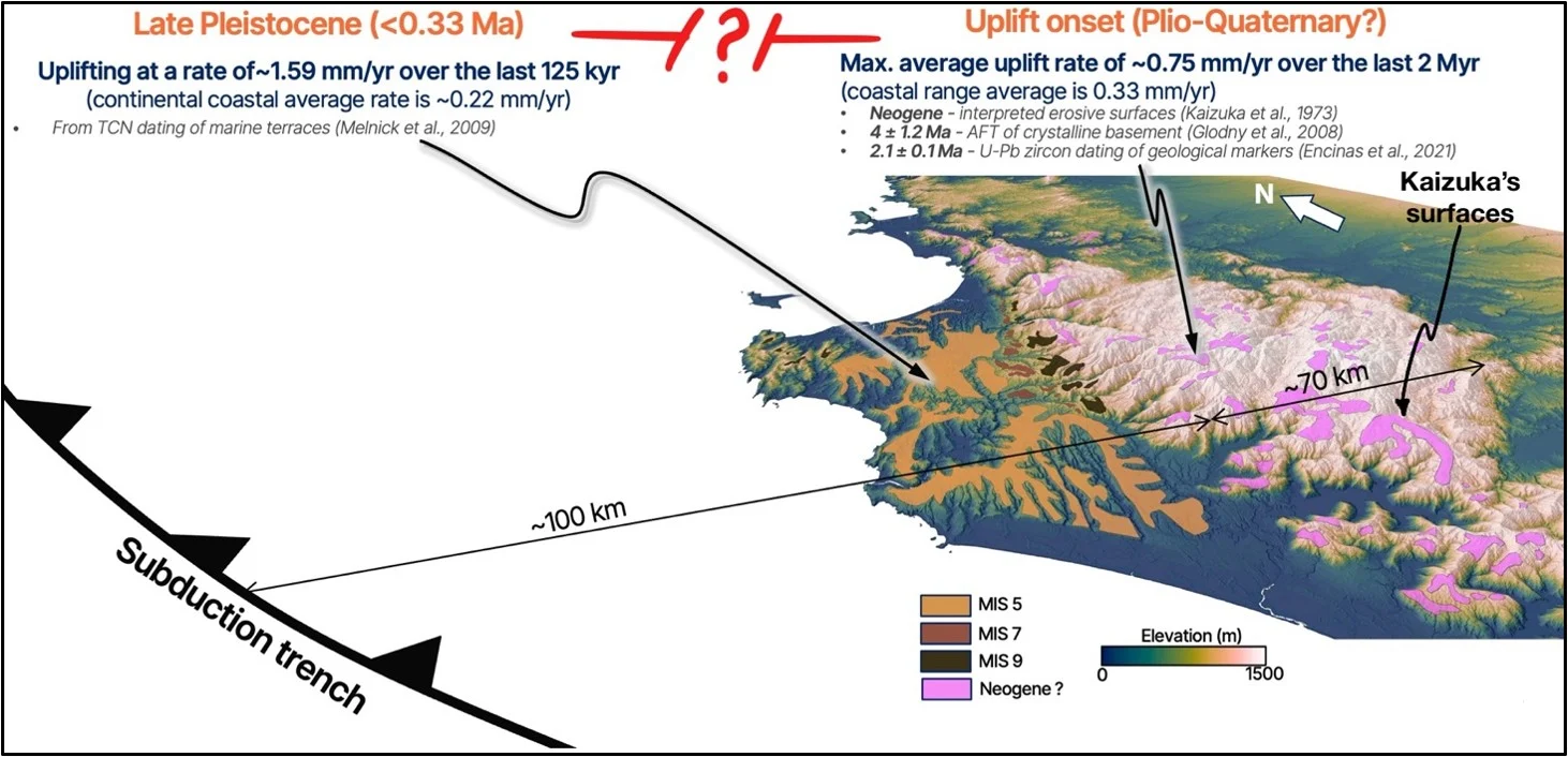
Figure 3. Geologic markers across the Arauco Peninsula and Nahuelbuta Range. There is a long gap in uplift history between what is known from the Neogene and the Pleistocene.
This leaves the following key questions:
- When and why did the Nahuelbuta Range begin to uplift?
- How have uplift rates changed through time and why?
Finding a marker of uplift onset
We first went back to a classic paper by Kaizuka et al. (1973). Japanese researchers had mapped scattered low-relief surfaces across the Nahuelbuta Range and suggested they were continental surfaces of Neogene age. But beyond that, the surfaces were largely left unexplored.
Using a combination of detailed manual and semi-automated geomorphic mapping, we discovered that:
- Kaizuka’s isolated surfaces are actually part of a continuous paleolandscape preserved across the top of the range.
- Even better, part of this paleolandscape had already been dated by Rehak (2008) between 2.3 Myr and 4.2 Myr.
Jackpot! We have a dated geological marker recording the onset of uplift (Fig. 4a).
What rivers can reveal about mountain building
Since the first studies of the Nahuelbuta Range, the tools we use to read tectonic signals from landscapes have improved dramatically. We analyzed river catchments and profiles to identify signs of uplift. Then, using erosion rates to calibrate a linear inversion model (e.g., Racano et al., 2021), we reconstructed when those signals occurred in the past.
The results are very cool (Fig. 4b):
- Uplift started ~2.5 Myr ago, matching the age of the relic landscape.
- Even cooler, instead of rising steadily, the range grew through at least three distinct pulses.
The youngest pulses match the timing and uplift rates recorded by the marine terraces of the Arauco Peninsula. This agreement gives us confidence that we are capturing a close-to-real uplift history of the range.
Thus, we retrieved the first continuous uplift history of the Nahuelbuta Range, connecting the onset of uplift with the emergence of the marine terraces.
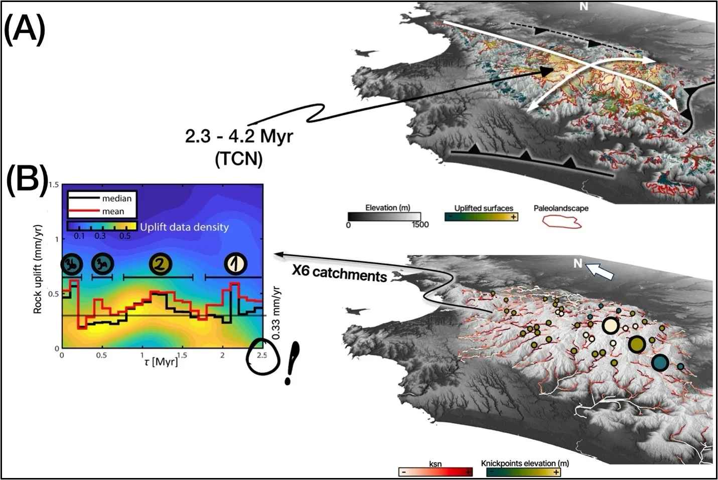
Figure 5. (A) Warped paleolandscape atop the Nahuelbuta Range. (B) Morphometric analysis and river inversion results. Knickpoints (circles) are colored by uplift pulse (left). Background shows uplift-rate density; red and black lines show mean and median rates from analyzed catchments. Graph modified from Vega-Ruiz et al. (2026).
What probably didn’t drive the uplift pulses
Several ideas don’t seem to fit the evidence.
Plate convergence rates and obliquity changed gradually. The Chiloé block collision likely reactivated reverse faults and helped shape the range, not in sync with the uplift pulses either.
The oceanic fracture zone arrived too recently to be the main driver, although it may have trapped additional sediment in the trench (Völker et al., 2013).
Frontal accretion also seems unlikely. It produces shorter surface wavelength deformation and occurs more than 100 km offshore.
Finally, sea-level changes are far too small to explain the hundreds of meters of baselevel changes recorded.
A tectonic-climatic interplay?
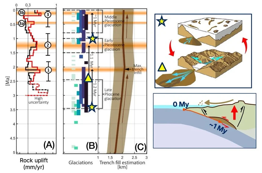
Figure 5. (A) Rock uplift curves from river-profile inversion. (B) Timing of glacial activity in Patagonia and the Southern Hemisphere. (C) Trench sediment thickness evolution. Upper cartoon: enhanced erosion and sediment delivery during glacial cycles. Lower cartoon: travel path and time of glacial sediments to reach their accretion depth. Graphs modified from Vega-Ruiz et al. (2026).
Patagonian glacial records show several periods of intensified glaciation during the Late Cenozoic that broadly match the periodicity of the uplift pulses (Fig. 5a–b). Along the Patagonian margin, ~80% of the kilometer-thick glacial sediment package is carried down the subduction zone instead of being accreted at the trench (Contreras-Reyes et al., 2010) (Fig. 5c).
Our calculations show that these sediments take ~1.1 ± 0.1 Myr to travel from the trench to beneath the Nahuelbuta Range (Fig. 5). Remarkably, this matches the delay between major glacial events and uplift pulses.
This suggests that large influx of glacial sediment pulses into the trench translated to episodes of basal accretion, driving the oscillatory uplift of the Nahuelbuta Range.
Does basal accretion actually make sense?
A good hypothesis needs a reality check. If basal accretion drove the uplift pulses, their size and duration should match what accretionary systems can produce.
Here’s a quick summary of the uplift history:
- Pulse 1: Starting ~2.5 Myr ago, coinciding with abandonment of the paleolandscape. It lasted ~0.8 Myr and affected a region about 70 km wide.
- Pulse 2: Starting ~1.7 Myr ago. ~1 Myr of duration and had a similar wavelength of ~70 km.
- Pulse 3a: Starting ~0.6 Myr ago, coinciding with the emersion of the Arauco Peninsula. It lasted ~0.3 Myr years and had a wavelength of ~40 km.
- Pulse 3b: Starting ~0.2 Myr ago. ~0.2 Myr of duration and also had a wavelength of ~40 km.
Scaling laws of Hoth et al. (2007) for accretionary systems suggest that Pulses 1 and 2 require accreted slices ~46–66 km long. An independent geometric approach based on Veliz-Borel et al. (2024) gives a similar result: ~50–70 km long slices rooted at ~40 km depth, beneath the Nahuelbuta Range.
If Pulses 3a and 3b are considered separately, they require unrealistically small ~7 km slices. But if they represent a single longer cycle, as expected for transient basal accretion (Menant et al., 2020), the required slices are ~26–34 km long, reaching depths of ~34 km, beneath the Arauco Peninsula.
In short, the size and timing of the uplift pulses match what we would expect from episodic basal accretion.
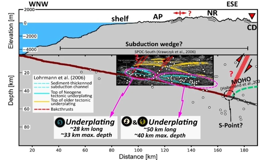
Figure 6. Seismic evidence pointing to the existence of basal accretion of sediments beneath the Nahuelbuta Range, at the same locations that our geometric and scaling analysis suggest.
The existence of our basal accretion bodies is supported by seismic data
Seismic imaging shows a >2 km-thick, sediment-rich subduction channel that extends down to the continental Moho (Krawczyk et al., 2006). This is consistent with reflectors indicating bodies of Neogene basal accreted sediments (Lohrmann et al., 2006) and with clusters of crustal seismicity located just above the plate interface (Bohm et al., 2002; Haberland et al., 2006) (Fig 6).
Implications for subduction dynamics
This study highlights one of the few active examples where forearc uplift is directly linked to episodic basal accretion, potentially influenced by glacial–interglacial cycles. But it also raises broader questions:
- Does this mechanism operate elsewhere along the margin, and if so, are these uplift pulses synchronized across Patagonia or do they vary from place to place?
- Are uplift pulses synchronized across Patagonia or do they vary from place to place?
- More broadly, could climate play a larger role in the long-term evolution of forearc systems than previously thought?
Finding out whether this behavior is unique to Patagonia or common in sediment-rich subduction zones will help us better understand how subduction zones evolve through time.
References:
[1] Bohm, M., Lüth, S., Echtler, H., Asch, G., Bataille, K., Bruhn, C., Rietbrock, A., and Wigger, P., 2002. The Southern Andes between 36° and 40°S latitude: seismicity and average seismic velocities. Tectonophysics, 356, 275–289. https://doi.org/10.1016/S0040-1951(02)00399-2

[2] Contreras-Reyes, E., Flueh, E. R., and Grevemeyer, I., 2010. Tectonic control on sediment accretion and subduction off south central Chile: Implications for coseismic rupture processes of the 1960 and 2010 megathrust earthquakes. Tectonics, 29. https://doi.org/10.1029/2010TC002734

[3] Encinas, A., Sagripanti, L., Rodríguez, M. P., Orts, D., Anavalón, A., Giroux, P., Otero, J., Echaurren, A., Zambrano, P., and Valencia, V., 2021. Tectonosedimentary evolution of the Coastal Cordillera and Central Depression of south-Central Chile (36°30′-42°S). Earth. Sci. Rev., 213, 103465. https://doi.org/10.1016/j.earscirev.2020.103465

[4] Folguera, A. and Ramos, V. A., 2009. Collision of the Mocha fracture zone and a <4 Ma old wave of orogenic uplift in the Andes (36°–38°S). Lithosphere, 1, 364–369. https://doi.org/10.1130/L66.1

[5] Haberland, C., Rietbrock, A., Lange, D., Bataille, K., and Hofmann, S., 2006. Interaction between forearc and oceanic plate at the south-central Chilean margin as seen in local seismic data. Geophys. Res. Lett., 33. https://doi.org/10.1029/2006GL028189

[6] Hoth, S., Hoffmann-Rothe, A., and Kukowski, N., 2007. Frontal accretion: An internal clock for bivergent wedge deformation and surface uplift. J. Geophys. Res. Solid Earth, 112. https://doi.org/10.1029/2006JB004357

[7] von Huene, R. and Scholl, D. W., 1991. Observations at convergent margins concerning sediment subduction, subduction erosion, and the growth of continental crust. Reviews of Geophysics, 29, 279–316. https://doi.org/10.1029/91RG00969

[8] Kaizuka, S., Matsuda, T., Nogami, M., and Yonekura, N., 1973. Quaternary tectonic and recent seismic crustal movements in the Arauco Peninsula and its environs, central Chile. Geographical Reports of Tokyo Metropolitan University, 1–49.

[9] Krawczyk, C. M., Mechie, J., Lüth, S., Tašárová, Z., Wigger, P., Stiller, M., Brasse, H., Echtler, H. P., Araneda, M., and Bataille, K., 2006. Geophysical Signatures and Active Tectonics at the South-Central Chilean Margin, in: The Andes: Active Subduction Orogeny. Edited by: Oncken, O., Chong, G., Franz, G., Giese, P., Götze, H.-J., Ramos, V. A., Strecker, M. R., and Wigger, P.. Springer Berlin Heidelberg, Berlin, Heidelberg, 171–192.

[10] Lohrmann, J., Kukowski, N., Krawczyk, C. M., Oncken, O., Sick, C., Sobiesiak, M., and Rietbro, A., 2006. Subduction Channel Evolution in Brittle Fore-Arc Wedges — a Combined Study with Scaled Sandbox Experiments, Seismological and Reflection Seismic Data and Geological Field Evidence, in: The Andes: Active Subduction Orogeny. Edited by: Oncken, O., Chong, G., Franz, G., Giese, P., Götze, H.-J., Ramos, V. A., Strecker, M. R., and Wigger, P.. Springer Berlin Heidelberg, Berlin, Heidelberg, 237–262.

[11] Melnick, D., Bookhagen, B., Echtler, H. P., and Strecker, M. R., 2006. Coastal deformation and great subduction earthquakes, Isla Santa María, Chile (37°S). GSA Bulletin, 118, 1463–1480. https://doi.org/10.1130/B25865.1

[12] Melnick, D., Bookhagen, B., Strecker, M. R., and Echtler, H. P., 2009. Segmentation of megathrust rupture zones from fore-arc deformation patterns over hundreds to millions of years, Arauco peninsula, Chile. J. Geophys. Res. Solid Earth, 114, 1407. https://doi.org/10.1029/2008JB005788

[13] Menant, A., Angiboust, S., Gerya, T., Lacassin, R., Simoes, M., and Grandin, R., 2020. Transient stripping of subducting slabs controls periodic forearc uplift. Nature Communications, 11:1, 11, 1–10. https://doi.org/10.1038/s41467-020-15580-7

[14] Racano, S., Schildgen, T. F., Cosentino, D., and Miller, S. R., 2021. Temporal and Spatial Variations in Rock Uplift From River-Profile Inversions at the Central Anatolian Plateau Southern Margin. J. Geophys. Res. Earth Surf., 126, e2020JF006027. https://doi.org/10.1029/2020JF006027

[15] Rehak, K.: Pliocene-Pleistocene Landscape Evolution in South-Central Chile [Ph. D. thesis], 2008.

[16] Vega-Ruiz, A., Delgado, V., Racano, S., Clementucci, R., Veliz-Borel, V., Espinoza, M., Encinas, A., Melnick, D., Larregla, R., Asenjo, C., and Zambrano, P., 2026. Tectonic and climatic controls on uplift transients of the Nahuelbuta Forearc Range, Northern Patagonian Andes. Earth Planet. Sci. Lett., 690, 120098. https://doi.org/10.1016/j.epsl.2026.120098

[17] Veliz-Borel, V., Mouslopoulou, V., Glodny, J., Begg, J., Metzger, S., Sakellariou, D., and Oncken, O., 2024. Exploring Uplift Mechanisms Across the Forearc of a Subduction System: Karpathos Island as a Natural Transect Across the Eastern Hellenic Margin. Tectonics, 43, e2023TC008156. https://doi.org/10.1029/2023TC008156

[18] Völker, D., Geersen, J., Contreras-Reyes, E., and Reichert, C., 2013. Sedimentary fill of the Chile Trench (32-46°S): Volumetric distribution and causal factors. J. Geol. Soc. London., 170, 723–736. https://doi.org/10.1144/jgs2012-119