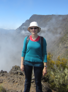
Eva Bredow in front of the caldera at Réunion Island. Credit: Simon Stähler.
This week we again turn our attention to a Remarkable Region that deserves a spot in the scientific limelight. Postdoctoral researcher Eva Bredow of Kiel University shares with us her long history with Réunion Island.
At first glance, Réunion is a relatively small tropical island, located between Madagascar and Mauritius, and from my personal experience, most Germans have never even heard of it. To be fair, it is much better known in France, because Réunion is officially a French overseas department, meaning that the eleven-hour flight from Paris is technically a domestic flight and that you can pay there with Euros (and I bet you did not know that a millimetre-sized outline of the island appears on every Euro banknote!). Besides, Réunion hosts one of the most active volcanoes in the world with one eruption per year on average. However, it rarely hits the headlines because the inhabitants live far enough away not to be overly threatened. And yet, for people interested in geodynamics, the name Réunion might actually have a familiar sound, since it regularly appears in hotspot catalogues and hotspot reference frames – a sure indication that there is more to discover.
For me, Réunion has been a very special place ever since I was a high school student lucky enough to visit the island in order to learn French. And who would have thought back then that hiking in this surreal volcanic landscape would be one of the first steps towards my decision to study geophysics? And what were the odds to stumble upon a PhD project years later, centred around the Réunion hotspot? Well, that is exactly what happened and in this article, it is my pleasure to give you at least a brief overview of why Réunion deserves to be called a remarkable spot indeed and how numerical modelling can help us to explore its geodynamic history.
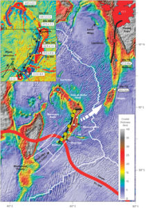
Crustal thickness map of the north-western Indian Ocean with the entire hotspot track from Réunion Island to the Deccan Traps in India. Figure from Torsvik et al. (2013).
A deep root
The hypothesis that Réunion is an intraplate hotspot possibly fed by a hot, buoyant upwelling rooted deep in the mantle was already put forward by Jason Morgan (1971, 1972) in his famous papers outlining the classical mantle plume hypothesis. And as it happens, the Réunion plume has left a number of traces that fit the plume hypothesis extremely well and make it a kind of prototype for a deep plume and its surface manifestations. A brief look at a topographic map of the north-western Indian Ocean reveals not only the currently active hotspot at Réunion and the slightly older island of Mauritius, but also a clearly continuous (and age-progressive) hotspot track on the African and Indian plates, only split due to subsequent seafloor-spreading.
According to numerous laboratory and numerical studies that describe the mushroom-like geometry of a plume, the hotspot track is considered to be caused by the long-lived plume tail, whereas the voluminous plume head is supposed to create a huge flood basalt province in a relatively short geological time (Richards et al., 1989). In the case of the Réunion plume, the hotspot track starts at the Deccan Traps, a gigantic continental Large Igneous Province (LIP) in India. The LIP was created around 65 million years ago and the environmental changes triggered by the volcanic activities might have led to the extinction of the dinosaurs (an alternative theory to the Chicxulub impact in Mexico; Courtillot and Renne, 2003).
Further indications for a deep plume beneath Réunion include the broad topographic hotspot swell around the island, a geochemical signature of the volcanic rocks that clearly deviates from mid-ocean ridge basalts, and the present-day hotspot location above the plume generation zone at the margin of the African Large Low Shear Velocity Province (LLSVP).
Plume-ridge interaction
A more puzzling observation is the geochemical anomaly at the closest segments of the Central Indian Ridge, about 1000 km away from Réunion that implies a long-distance plume-ridge interaction. Already Morgan (1978) suggested that a sublithospheric flow channel connecting the upwelling plume and the ridge is responsible for the creation of the Rodrigues Ridge, a rather eye-catching feature not at all parallel to the hotspot track or recent plate motions.
And there is one more noteworthy hypothesis associated with Réunion, based on extremely old zircons found at Mauritius; it postulates that the hotspot track has (coincidentally) been created on top of a Precambrian microcontinent (Ashwal et al., 2017).
The RHUM-RUM experiment (completely alcohol-free…)
Concerning the (present-day) state of the Réunion plume at greater depths, seismic tomography is the most promising tool to answer the question if it is indeed fed by a deep plume or not. But given that the island is rather remotely located and a classical plume tail is expected to be quite narrow, there are plenty of technical obstacles, and it was not until 2006 that Montelli published the first seismic image of a continuous plume conduit reaching into the deep mantle. More recent global tomography models also image the Réunion plume as a clearly resolved, vertically continuous conduit at depths between 1,000 and 2,800 km (French and Romanowicz, 2015).
In 2012-2013, the French-German RHUM-RUM project (Réunion Hotspot and Upper Mantle – Réunions Unterer Mantel) aimed at an even higher resolved image of the plume. Therefore, 57 German and French ocean-bottom seismometers were deployed at the seafloor around Réunion for about a year (Stähler et al., 2016) – still the largest seismological experiment to image a deep oceanic mantle plume so far.
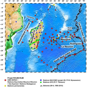
All seismic stations related to the RHUM-RUM project, with the 57 ocean-bottom seismometer stations shown in red. More information on the project can be found here.
With all that in mind, and as part of the RHUM-RUM project, I set up a regional numerical model with some colleagues from the GFZ Potsdam in order to assemble Réunion’s entire dynamic history. We used time-dependent plate reconstructions and large-scale mantle flow as velocity boundary conditions as well as a laterally varying lithosphere thickness in order to specifically simulate the Réunion plume (for details, see Bredow et al., 2017). In short: altogether, we were able to reproduce a crustal thickness pattern that at first order fits the observed hotspot track (although the method is not suited to reproduce a continental LIP such as the Deccan Traps). Moreover, the interaction between the plume and the Central Indian Ridge explained both the genesis of the Rodrigues Ridge and the gap in crustal thickness between the Maldives and Chagos – both features that have not been dynamically modelled before.
After our models were published, the active long-distance plume-ridge interaction beneath the Rodrigues Ridge was additionally confirmed by seismological studies in the RHUM-RUM project: first in a three-dimensional anisotropic S-wave velocity model comprising the uppermost 300 km (Mazzullo et al., 2017), and second by SKS splitting measurements (Scholz et al., 2018). Overall, these interdisciplinary studies confirmed Morgan’s long-standing hypothesis – more than 30 years after its original publication.
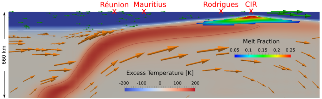
Cross section of the geodynamic plume model, showing the long-distance plume-ridge interaction as predicted by Morgan (1978). Figure after Bredow et al. (2017).
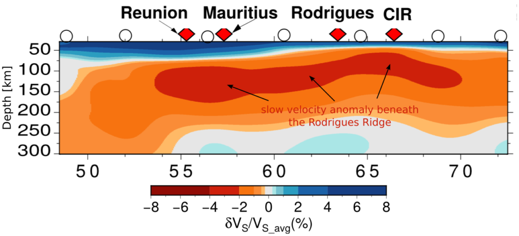
Cross section of the surface wave tomography model, showing the low velocity signature of the plume rising toward the base of the lithosphere underneath Réunion and the sublithospheric flow toward the Central Indian Ridge (CIR). Figure after Mazzullo et al. (2017).
The whole-mantle P- and S-wave tomography models from the RHUM-RUM project have yet to be published, but the (almost final) results presented at this year’s EGU (Tsekhmistrenko et al., 2019) were quite intriguing: while the plume conduit can continuously be followed down to the LLSVP in the deep mantle, the conduit is not as narrow and not nearly as vertical as classically expected!
Therefore I think it is quite safe to say that we have not yet heard the last of the Réunion hotspot and I hope that the next time you hear this name, maybe you will remember it as a rather remarkable spot on our planet…
Ashwal et al. (2017), Archaean zircons in Miocene oceanic hotspot rocks establish ancient continental crust beneath Mauritius, Nat. Commun., 8, 14,086, doi: 10.1038/ncomms14086.

Bredow, E. et al. (2017), How plume-ridge interaction shapes the crustal thickness pattern of the Réunion hotspot track, Geochem. Geophys. Geosyst., 18, doi:10.1002/2017GC006875.

Courtillot, V. E. and P. R. Renne (2003), On the ages of flood basalt events, C. R. Geosci., 335(1), 113–140, doi: 10.1016/S1631-0713(03)00006-3.

French, S. W. and B. Romanowicz (2015), Broad plumes rooted at the base of the Earth’s mantle beneath major hotspots, Nature, 525, 95–99, doi: 10.1038/nature14876.

Mazzullo, A. et al. (2017), Anisotropic tomography around Réunion Island from Rayleigh waves Journal of Geophysical Research: Solid Earth, 122, doi: 10.1002/2017JB014354.

Montelli, R. et al. (2006), A catalogue of deep mantle plumes: New results from finite-frequency tomography, Geochem. Geophys. Geosyst., 7, Q11007, doi: 10.1029/2006GC001248.

Morgan, W. J. (1971), Convection plumes in the lower mantle, Nature, 230, 42–43, doi: 10.1038/230042a0.

Morgan, W. J. (1972), Deep mantle convection plumes and plate motions, AAPG bulletin, 56(2), 203–213.

Morgan, W. J. (1978), Rodriguez, Darwin, Amsterdam, ..., A second type of Hotspot Island, J. Geophys. Res., 83(B11), 5355–5360, doi: 10.1029/JB083iB11p05355.

Richards, M. A. et al. (1989), Flood Basalts and Hot-Spot Tracks: Plume Heads and Tails, Science, 246, 103–107, doi: 10.1126/science.246.4926.103.

Scholz, J.-R. et al. (2018), SKS splitting in the Western Indian Ocean from land and seafloor seismometers: Plume, plate and ridge signatures, Earth Planet. Sci. Lett., Volume 498, 169-184, doi: 10.1016/j.epsl.2018.06.033.

Stähler, S. C. et al. (2016), Performance report of the RHUM-RUM ocean bottom seismometer network around La Réunion, western Indian Ocean, Adv. Geosci., 41, 43-63, doi: 10.5194/adgeo-41-43-2016.

Torsvik, T. H. et al. (2013), A Precambrian microcontinent in the Indian Ocean, Nat. Geosci., 6(3), 223–227, doi: 10.1038/ngeo1736.

Tsekhmistrenko, M. et al. (2019), Deep mantle upwelling under Réunion hotspot and the western Indian Ocean from P- and S-wave tomography, Geophysical Research Abstracts, Vol. 21, EGU2019-9447, EGU GA 2019.