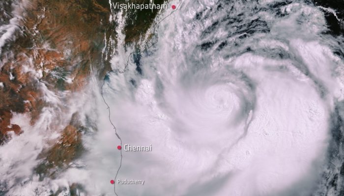
Hurricane, cyclone and typhoon are different terms for the same weather phenomenon: torrential rain and maximum sustained wind speeds (near centre) exceeding 119 km/hour (World Meteorological Organization https://public.wmo.int/en). The terminology depends on the region (e.g. in the western North Pacific, they are called typhoons; in the Bay of Bengal and the Arabian Sea they are named as cyclones, etc). The Indian sub-continent is highly vulnerable to cyclones and the losses to life are more pronounced due to high population density (National Cyclone Risk Mitigation Project, Govt of India). Studies show a decreasing trend in the frequency of cyclones over the North Indian Ocean in recent years, however, the damage and destruction from such systems do not seem to decrease (e.g. De et al., 2005). In April 2019, Cyclone Fani was the first summer cyclone to hit India’s Bay of Bengal coast in 43 years and only the third in the past 150 years. It was also the strongest tropical cyclone to hit India since 2013 and affected 137 blocks (district subdivisions for rural areas consisting of a cluster of villages), 46 municipal governments, 14,800 villages, and 15,000 km of roads. About 5 million people lost their houses, 14 million people were affected and $14 billion is now estimated for rebuilding damaged houses and public infrastructure.
Fani (pronounced as Foni, meaning ‘hood of a snake’ in Bengali) had the longest ever observed lifecycle over the Bay of Bengal (11 days). It originated from a tropical depression that formed west of Sumatra on the Indian Ocean on April 26th 2019. Fani rapidly intensified into an extremely severe cyclonic storm (the equivalent of a high-end category 4 ‘major hurricane’) and reached its peak on May 3rd when it made landfall close to Puri in Odisha with a maximum sustained wind speed of 180-190 km/h. After landfall, it weakened gradually and entered into West Bengal as a Severe Cyclonic Storm with wind speeds of 90-100 km/h gusting to 115 km/h. A storm surge of 1.5-meter height above astronomical tide was forecasted to inundate low lying areas in Odisha at the time of landfall. The India Meteorological Department started observing it as soon as it formed as a low-pressure area in the Indian Ocean. Throughout the lifecycle of the cyclone, SCATSAT-1 satellite imagery of the Indian Space Research Organisation was used to track the location, direction and intensity of winds close to the ocean surface. Along with the satellite imagery, data from Doppler radars at Kolkata, Chennai, Gopalpur, Paradip, and Machilipatnam was fed into two ocean-atmospheric coupled simulation models for forecasting the prospective track and intensification of the cyclone. The Doppler radars helped in keeping watch on the cyclone throughout and improvising the forecast of frequently changing cyclone track. Figure 1 shows the lifecycle of cyclone Fani and the forecast iterations.
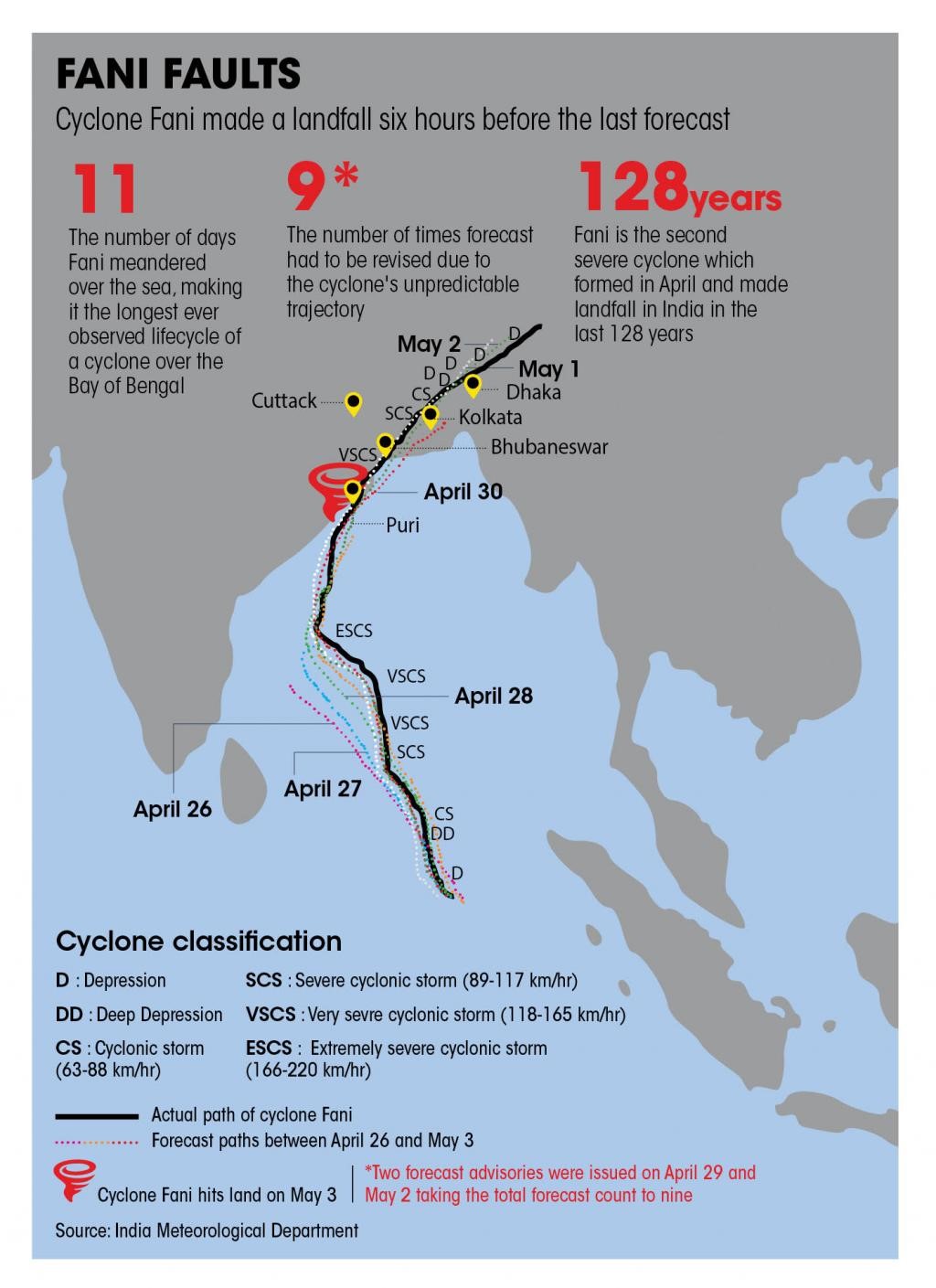
Fig 1. The lifecycle of Cyclone Fani. Source: India Meteorological Department
The India Meteorological Department alerted the Union Ministry of Home Affairs, state authorities and district administration of the cyclone and ground authorities received hourly updates through bulletins, WhatsApp groups and emails. The disaster management authorities in India were then able to launch a massive and timely evacuation and preparedness action involving more than 1 million people suspending fishing operations, road traffic, closing schools and airports. The organizational efficiency, commitment and the efforts put in by the government authorities in limiting the damage were commendable. To get vulnerable people to safer areas, authorities sent out 2.6 million text messages, 43,000 volunteers, nearly 1,000 emergency workers, television commercials, coastal sirens, buses, police officers, and public address systems blaring the same message on a loop, in local language, in very clear terms: “A cyclone is coming. Get to the shelters”. The state government evacuated about 1.39 million people to temporary shelters and the Indian Army helped set up more than 15,000 free kitchen camps to serve as many as 2.6 million affected people. The death toll, however, was limited to 72 people in India. Comparing big weather events around the world, the death toll was 10,000 during Odisha cyclone in 1999, more than 1,000 during cyclone Idai in Madagascar, Malawi, and Zimbabwe in 2019, and about 3,000 during Hurricane Maria in Puerto Rico in 2017. This is, by far, a success of the ‘no casualty policy’ adopted by the Indian disaster management agencies. The United Nations Office for Disaster Risk Reduction (UNISDR) and other organisations hailed the Indian government and volunteer efforts for saving thousands of lives. Clear command and control structure for disaster relief, clear communication plan, the accuracy of an early warning system and effective coordination among organisations and groups are some of the things the world could learn from Odisha in development of effective disaster management plans and save millions of lives.
FUN FACTS: CYCLONE NAMING
The naming of tropical cyclones is a recent phenomenon. The process of naming cyclones involves several countries in the Asian region and is done under the aegis of the World Meteorological Organization. Eight countries in the region – Bangladesh, India, Maldives, Myanmar, Oman, Pakistan, Sri Lanka and Thailand – all contribute a set of names which are assigned sequentially whenever a cyclonic storm develops. Cyclone Fani was named by Bangladesh. Why naming a cyclone? Names are presumed to be far easier to remember than numbers and technical terms considering also the media reporting, having much visibility in warnings and increasing community preparedness.
Written by: Amogh Mudbhatkal and Giulia Roder
 Dr Amogh Mudbhatkal is a Postdoctoral Research Asst. (Hydrological, Hydraulic & Sediment Modelling) at the School of Geography and Lincoln Centre for Water and Planetary Health (Lincoln, UK). He obtained his Bachelor’s degree in Civil Engineering and Master’s degree in Environmental Engineering from the Visvesvaraya Technological University, India. He obtained his PhD in Water Resources at the National Institute of Technology Karnataka, India, in 2017 with a thesis on the hydrological impacts of climate change on the rivers of Western Ghats of India. Amogh began his teaching career in Jain College of Engineering, India, in 2013 and later joined the Indian Institute of Technology Roorkee. At IIT Roorkee, he worked on the environmental impacts of hydropower projects in Alaknanda, Bhagirathi, Yamuna, and Sutlej river basins. He joined the School of Geography at the University of Lincoln, UK, in 2017. His current research examines for the first time the environmental impact of metal mines and tailings storage facilities worldwide, using a suite of high-resolution data sets.
Reference:
[1] World Meteorological Organization, Disaster preparedness limits toll from Cyclone Fani
https://public.wmo.int/en/media/news/disaster-preparedness-limits-toll-from-cyclone-fani
[2] Indian red Cross Society, Odisha Fani Assessment Report https://www.indianredcross.org/notices/OdishaFaniAsessmentReport.pdf
[3] National Portal of Government of India, Cyclone Fani in the news https://www.india.gov.in/



amel fs
Merci pour l’article
Amel snv
Thanks for sharing this great article
amel sm
Nice post
Prediksi Bola dan Togel Paling Jitu
Awesome article, strike to the point, thanks for sharing