In today’s interview, we talk with Dr Vitor Silva, who was awarded the 2020 Natural Hazard Division Outstanding Early Career Scientist Award for his fundamental contributions to the research on earthquake risk assessment. Seismic risk is the probable building damage and the number of people that are expected to be hurt or killed if a likely earthquake on a particular fault occurs. Disaster risk can be seen as a function of the hazard, exposure and vulnerability. The assessment of earthquake risk constitutes the first step to support decisions and actions to reduce potential losses and involves developing (a) earthquake hazard models characterising the level of ground shaking and its associated frequency across a region, (b) exposure data sets defining the geographic location and value of the elements exposed to the hazards and (c) vulnerability functions establishing the likelihood of loss conditional on the shaking intensity (UNISDR 2017).
Hi Vitor, can you please briefly introduce yourself?
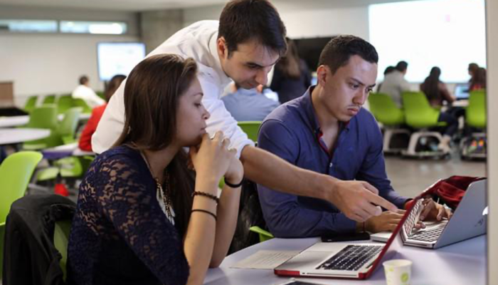
My name is Vitor Silva, and I am the Risk Coordinator at the Global Earthquake Model (GEM) Foundation. In the last decade, I have been developing tools and models required to understand the impact of earthquakes at the local, national and regional scales. I am from Portugal but have spent an important part of my life in Italy, where the GEM Foundation headquarters is located. These efforts have taken me to amazing places in Europe, Africa, Asia and America (yes, Oceania is still missing, but not forgotten), to work with some of the best scientists within the fields of seismic hazard modelling, risk assessment and loss estimation. These activities also include working with local experts and students, where we try to improve the local capacity to assess seismic hazard and risk or to better catalogue the building stock.
You have been awarded the 2020 Natural Hazard Division Outstanding Early Career Scientist Award. First of all: congratulations! Can you tell us a bit more about the focus of your research?
Well, my focus of research has rather evolved unnaturally. Yes, I started with the basics of earthquake engineering and statistics, developing vulnerability models and assessing earthquake risk for my home country, Portugal. However, once I became the Risk Coordinator of GEM, I had to radically and rapidly adjust to the requirements of several projects and stakeholders, and more importantly, to ensure that we were aligned with the state-of-the-art, or at least not behind the state-of-the-practice. Moreover, I was given the mammoth task of coordinating the development of the risk component of a global earthquake model, with an unprecedented level of detail. I had to be creative and rely on recent technology to automate procedures and explore global datasets that allowed us to go where no risk modeller had gone before! This global seismic risk map identifies the expected annual economic and human losses due to earthquake ground shaking. It allows understanding directly what are the regions in the world where disaster risk reduction measures should be prioritized.
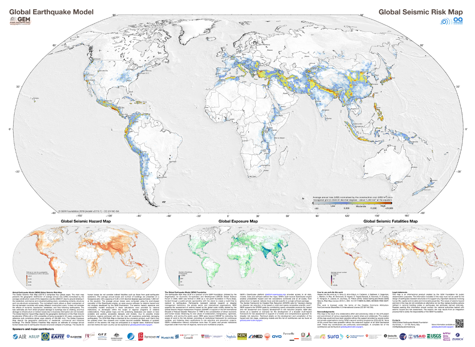
Global Seismic Risk Map (Silva et al. 2020) released by the GEM Foundation in December 2018. More information can be found at https://www.globalquakemodel.org/gem
This process of developing a global earthquake model also allowed me to identify the current challenges and trends in earthquake loss assessment, which got me interested in the usual suspects: machine learning, earth-observation datasets and crowd-sourced data.
What are the open questions related to earthquake risk assessment?
Earthquake risk assessment is definitely not a mature field, at least in comparison with its cousins: the seismic hazard modelling or vulnerability assessment. A quick look at the literature will tell you that. Most of the countries have a seismic hazard model, as this is fundamental to define the seismic hazard demand to design better and safer buildings. You can also find literally hundreds of studies about the vulnerability of buildings and infrastructure, but it’s the final step of putting all the ingredients together and cooking a fine seismic risk assessment that is missing.
Some of the reasons behind this paucity of earthquake risk studies worldwide are related to the lack of intuitive tools, outdated datasets or insufficient expertise to perform risk analysis. I have been in several parts of the world where a seismic risk study is still regarded as a luxury, or something only academics do for academic reasons. And perhaps this was the case some years ago. Nowadays, there are international agendas such as Sendai or the UN SDGs that ask specifically for a better understanding of risk. We now have governments asking for information before making decisions. And of course, the private sector, which in many ways is far more advanced than other sectors, and already uses risk information to develop new products or make existing ones more profitable.
In my view there are two main problems with the current risk assessment practice: 1) how do we keep it up-to-date, and 2) how do we expand to all assets? When you begin your risk assessment, you might already be reliant on datasets that are a few years old. By the time the assessment is finished, those datasets are even older. By the time the client starts making decisions with that risk information, those risk estimates might be ancient in the risk assessment time scale. Other buildings have been built, more people exist, the building stock has changed and perhaps an earthquake or cyclone has hit your region and now everything is different.
So how do we prevent risk assessment from becoming obsolete so quickly? How do we expand the expiration date of these assessments, which can cost millions of dollars? And even more importantly, how do we predict the evolution of earthquake risk for the next decades to ensure that any risk reduction measure accounts for the expected changes in the population and built environment? Probably the solution is in crowd-sourced data and in other initiatives that are rapidly cataloguing everything around us using artificial intelligence. Many years ago, a road trip implied maps and books. Now you can find all of that on your smartphone.
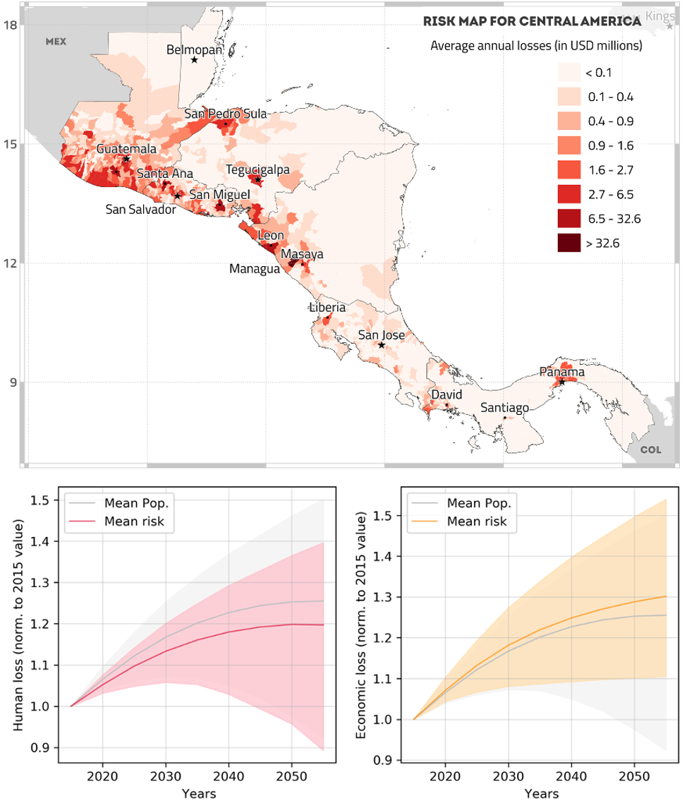
Seismic risk assessment for Central America, indicating the expected average annual economic losses at each administrative division (top), and projection of the evolution of human and economic losses for the Great Metropolitan Area of Costa Rica for the next 4 decades (bottom) (Calderon et al. 2020 under review).
As for the second open question, when I did my first risk assessment I considered only residential buildings. I thought I did a good job until someone told me “This is not bad, but what about commercial and industrial buildings? Those are important too”. So I included these two other occupancies, and then someone said “This is not bad, but what about public buildings and the transportation network? Those are important too”. Then came the educational infrastructure, healthcare facilities, lifelines and cultural heritage sites. My point is that risk assessment can be never-ending, and we need to have a systematic approach to cover all assets relevant to risk mitigation, and right now these are addressed almost on a case-by-case basis. So, earthquake risk assessment is no longer a toddler, but probably at the start of its adolescent years and trying to figure out the best way to grow.
You are the Seismic Risk Coordinator at the Global Earthquake Model (GEM) Foundation, what are the scopes of the GEM foundation?
The initial goal of the GEM Foundation was to calculate and communicate earthquake risk worldwide. That is still true, but much more has happened since then. Our sponsors and partners have asked us to develop a global seismic risk model, to expand the current tools to secondary geohazards, invest in capacity building worldwide and liaise with similar global initiatives that are doing fantastic work for other hazards. The mission of GEM is to contribute to a world that is resilient to earthquakes, either by developing hazard and risk information that is relevant to decision-makers or by supporting organizations directly with the remit to promote and implement disaster risk management policies.
Another aspect that is unique about GEM is the philosophy of transparency and openness that we follow in the development of the tools, models and datasets. All of the GEM tools are available on public repositories, and the models and datasets are either publicly available or shared directly with the partners. This is something that has helped tremendously to increase the GEM community, as well as to expand the potential of our products. We have people we have never met face-to-face contributing to the code, revising the models and reviewing the datasets. In return, they get tools with fewer bugs, models with higher reliability and datasets more up-to-date.
As I am answering these questions, we’re in the middle of the Covid-19 pandemic, so it is impossible for me not to make a parallel with the benefits of openness in the current situation. I have read countless stories in the last days of how finding a vaccine was facilitated due to the public release of the genetic code of the virus, or how several organizations are sharing technical specifications and drawings to produce ventilators. We’re obviously aware of the need to protect intellectual property and how some businesses depend on that, but we also work with extremely successful companies that contribute actively with models and knowledge to the field of earthquake risk assessment. Within the risk team at GEM that I lead, I have extraordinary hard-working and smart people focused on all facets of risk assessment.
As the world evolves, so must the risk assessment that we perform, so we have been focusing on the integration of machine learning, incorporation of satellite imagery and linking the work we do with emergent problems such as climate change and urban expansion. Whether we’re focusing on the right problems and following the right approaches, only time will tell us.
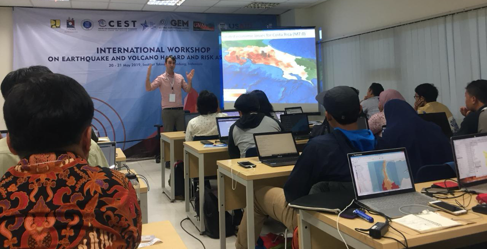
Earthquake and volcano risk workshop organized at Bandung University in Indonesia in collaboration with the Global Volcano Model.
References:
Silva V, Amo-Oduro D, Calderon A, Costa C, Dabbeek J, Despotaki V, Martins L, Pagani M, Rao A, Simionato M, Viganò D, Yepes-Estrada C, Acevedo A, Crowley H, Horspool N, Jaiswal K, Journeay M, Pittore M (2020). Development of a Global Seismic Risk Model. Earthquake Spectra, doi.org/10.1177/8755293019899953.
Calderon A, Silva V, Aviléz M, Méndez R, Castillo R, Gil J C, Lopez M A (2020). Towards a Uniform Earthquake Loss Model across Central America, Earthquake Spectra, in review.
Faculté des Lettres et Langues
Thanks for sharing such an wonderful thoughts