Reflections on the geological and geodynamic evolution of the Southern Central Andes
Today, Matias Barrionuevo shares with us his views on the tectonics and geodynamics of the Andes. Matias recently took up a position at the National Scientific and Technical Research Council (CONICET) in Argentina. He seeks to understand the formation of the Andes using a multidisciplinary approach, from structural geology and thermochronology to geodynamic modeling and the study of subduction and plate interaction.
For the one who looks without seeing, the Earth is just earth
(translation from the original in spanish: “Para el que mira sin ver, la Tierra es tierra nomás”, by Atahualpa Yupanqui an argentinean writer and musician).
Why are the Andes a source of interest ?
Dr. Matías Barrionuevo is a postdoctoral researcher at the National Scientific and Technical Research Council (CONICET-Argentina) working on the tectonic and geodynamic evolution of the Andes. In this blog post, he shares his views on the complex interactions and challenges associated with the formation of the Andes using a multidisciplinary approach.
When we think about mountains, which ones come to our minds first? I guess it depends on where we are from, where we currently live, etc. In my case, when I think about mountains, the Andes appear as THE mountains. Why? Because I’m currently living at their foothills in Mendoza. For several years, naturalists, geologists and earth scientists have been working to understand how the Andes evolved through time. The Andes represent a natural laboratory to study the interactions between climatic, tectonic and geodynamic processes. In their first explorations, naturalists such as Darwin, Stelzner among others made some key observations about the formation and evolution of the Andes. For example, Darwin observed the presence of marine fossils up in the mountains, above 2000 or 3000 m. After witnessing the earthquake at Concepcion (Chile) in 1835 Darwin realized that some marine floor rocks had been uplifted over sea level due to the event. Darwin made the connection, while crossing the Andes from Chile to Argentina, when he understood that the marine fossils he had observed at high altitudes were likely uplifted by these seismic events, at long, geological, periods of time. Besides, he observed that the conglomerates filling some basins were composed of different clasts that were reflecting the uplift and erosion of rocks from distinct ranges. Based on this, he proposed a relative timing of mountain building, from west to east. He made all these observations at the time when plate tectonics theory was not established yet.
Despite several years of research since Darwin, many questions remain unanswered on the tectonic nature of the Andes. It is generally assumed that Andean mountain building happens by shortening through stacking crustal layers on top of the others, from the hinterland (arc-region) to the foreland. But that mechanism has some unknowns. Hence, the questions that my research group and I are interested in are: what happens in depth that leads to the surface expression of the Andes? Is there a ductile flow of the crust? Also, how mountain ranges evolve through time? Do the Andes grow laterally by shortening the foreland? What is the role of the subduction of the Nazca plate beneath the South American plate on the building of the Andes and what role plays the change of dip of the oceanic plate from steep to flat subduction observed in the Southern Central Andes? And going back in time, can we quantify the magnitude of the initial shortening phase almost 100 million years ago in the Late Cretaceous?
We are also interested in solving more “applied” questions relevant to societal challenges and risk hazards, such as what is the influence of pre-existing faults and fractures on the neotectonic (present-day) deformation and seismic events? How is the tectonic activity of these faults associated with fluid flow and the production of georesources (e.g. water, oil, hydrothermal fluids)?
In our research group, we are working to learn more about these processes related to this natural laboratory. Through several techniques, including fault surveying and their kinematic analysis, the interpretation of subsurface data from seismic and drillhole information, thermochronological analyses, the study of the basins filled up with sediments coming from erosion of the mountains and geodynamic modeling, we are trying to do our bit or as direct translation from spanish, to “contribute our grain of sand” to the knowledge about the Andes.
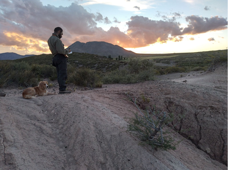
Figure 1: Writing down some observations about the Andes in southern Mendoza.
From the Sierras to the Andes: an introduction to the Southern Central Andes
I’m originally from Córdoba, located in Central Argentina. It is equidistant from Buenos Aires, the capital city located at the easternmost edge of our country, and equidistant to Mendoza, in its westernmost zone near the border with Chile…and at the foothills of the Andes. So, in Córdoba we are 500 km away from the Andes, but we have several ranges, grouped in the Sierras Pampeanas. Sierras means ranges, Pampeanas because they’re close to the “pampas” the plains that are a source of several crops. The Sierras are composed of metamorphic and igneous rocks (or basement) from paleozoic orogens (or very old mountains). In Córdoba these “Sierras” reach almost 3000 meters above sea level (masl), but in other provinces the Sierras are even higher… reaching up to 5500 masl.
So, how can a mountain, a Sierra, grow away from the convergent margin? Furthermore, how can we have active tectonics and earthquakes so far from the trench?
The geodynamic setting of the Sierras Pampeanas ?
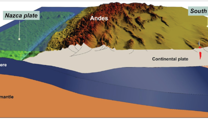
This “anomalous” tectonic setting appears to be related to the way the subducting plate, also called slab, sinks. When two tectonic plates, one oceanic and one continental, converge, the former, which is denser and harder than the continental plate, tends to go under the continental plate before diving into the asthenospheric mantle. The slab can dive or subduct with different inclinations into the mantle. In some cases, the slab flattens due to various factors, such as its high buoyancy. When that happens, it can transmit the horizontal stresses resulting from the forces of the plate convergence far away from the continental margin, leading to development of mountains such as the Sierras and also earthquakes far from the trench. Furthermore, this “flattening” causes minor volcanic activity 700 km away from the trench.
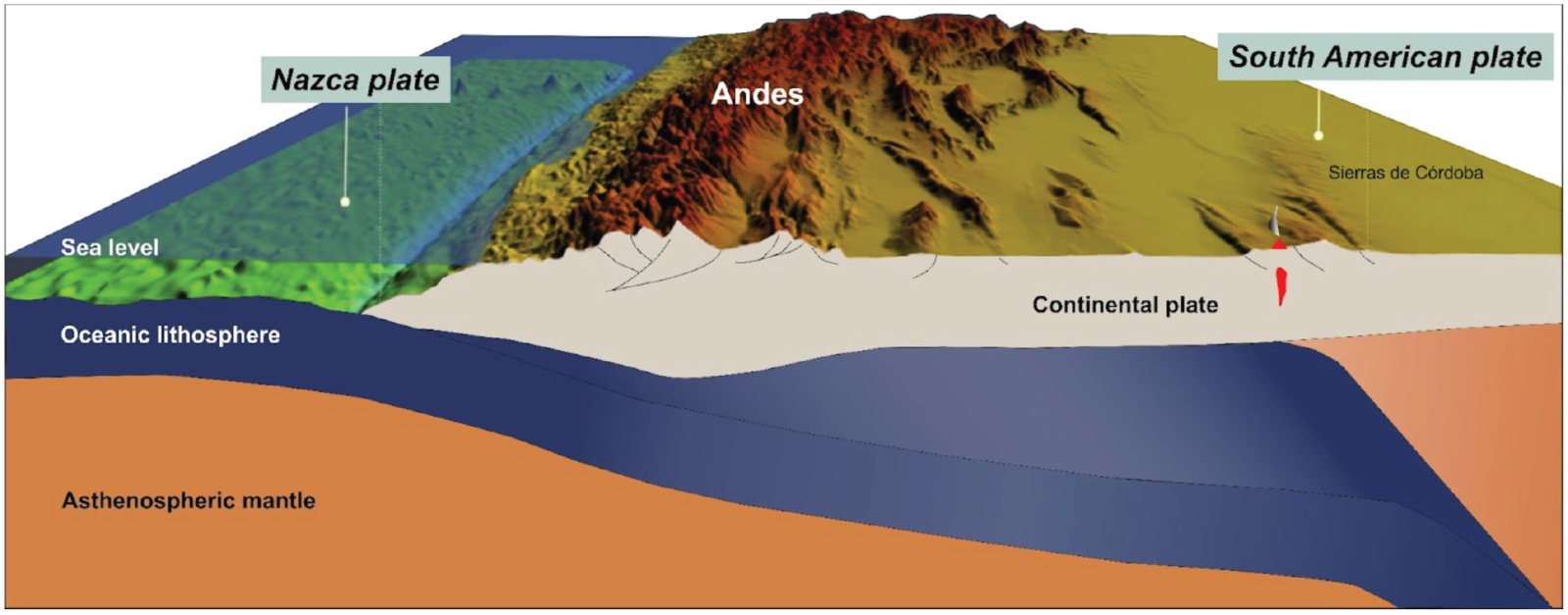
Figure 2 : Sketch showing the flat slab configuration, where the Nazca plate subducts beneath the South American plate with a subhorizontal angle. Note the location of the Sierras de Córdoba and the localized volcanism. Furthermore, the Sierras are uplifted by faults that have neotectonic activity. (Figure modified from Sanchez et al., 2019).
I moved from Cordoba to Mendoza, not only for the Malbec, the most renowned grape in Argentina, but also because I was interested in understanding the mechanisms responsible for the formation of the Andes and associated mountains. How did they grow? How did they evolve? Are there some differences between the Sierras and the Andes, and within the Andes?
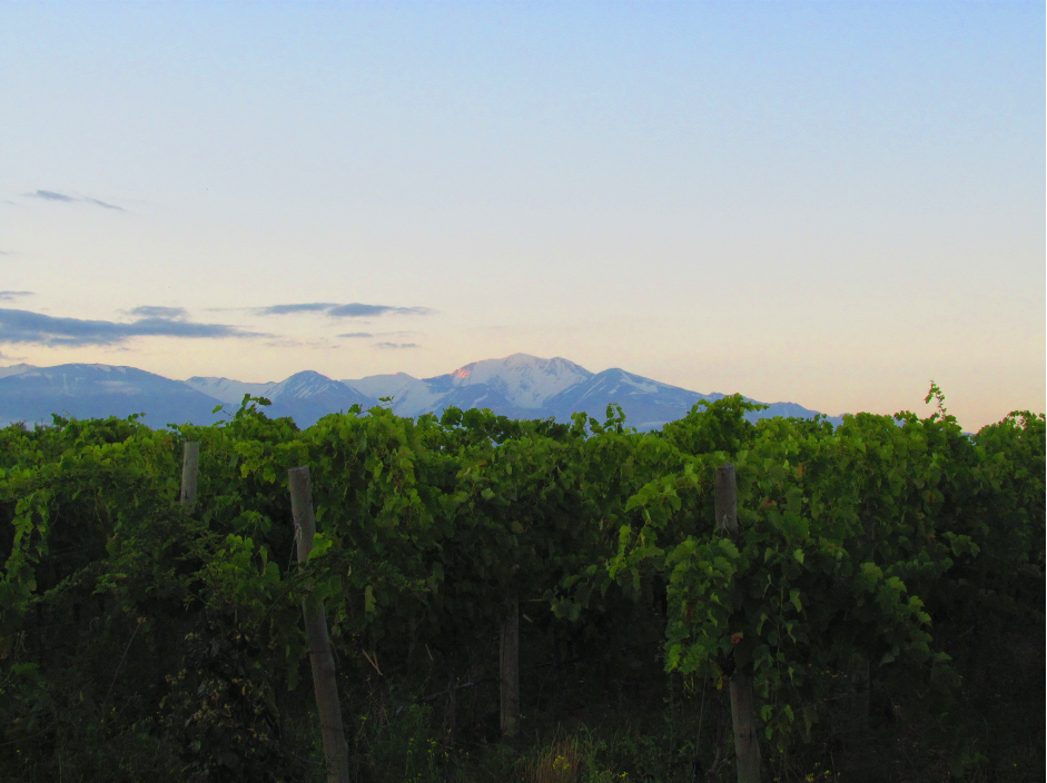
Figure 3 : Northwest view to the Cordón del Plata, in the Andes with Malbec grapevine in foreground.
I quickly realized that many of the questions that I posed at the beginning of this post cannot be solved on my own. That’s why I believe in conducting science with a collaborative and multidisciplinary approach, which has guided me through my years as a researcher. I would like to use these lines to briefly acknowledge the opportunity I had during my PhD, through a cooperation agreement between Argentina and Germany. That project, called StRATEGy, allowed me to travel to Germany, where I spent more than a year at the Geodynamic Modelling section in GFZ and also at the University of Potsdam. During that time, I had the opportunity to learn about numerical models applied to the study of mountain formation. But more importantly, I had the chance to work in collaboration with fellow colleagues, which resulted in fruitful discussions and the publication of our work.
What did we find ?
In our work, we built a geodynamic model replicating the pre-Andean configuration of the South American plate at 33.4°S and 36°S. We applied a constant velocity on the right side of the model, until we reach the shortening estimates equal to 45-70 km. We found that the composition of the crust is relevant to understand the different deformation styles we observed in the Southern Central Andes. Models with felsic crust (i.e., weaker rheology, figure 4, top pannels) are more subjected to viscous flow in the lower crust, while more mafic crust (i.e., stronger rheology, figure 4, bottom pannels) accommodates the deformation in shear zones (or faults) cutting the whole crust as inferred by the conceptual models proposed by Giambiagi et al (2012).
Furthermore, we investigated how the lithospheric thickness may be an important factor controlling the orogenic vergence, i.e. the direction of tectonic transport. We found that an asymmetric lithosphere-asthenosphere boundary (LAB) leads to east-directed shear zones. In our area of study, this asymmetry is likely controlled by the geometry of the eastward subduction zone. The asthenospheric corner flow would cause the the thinning of the lithosphere by mechanically and thermally eroding its base.
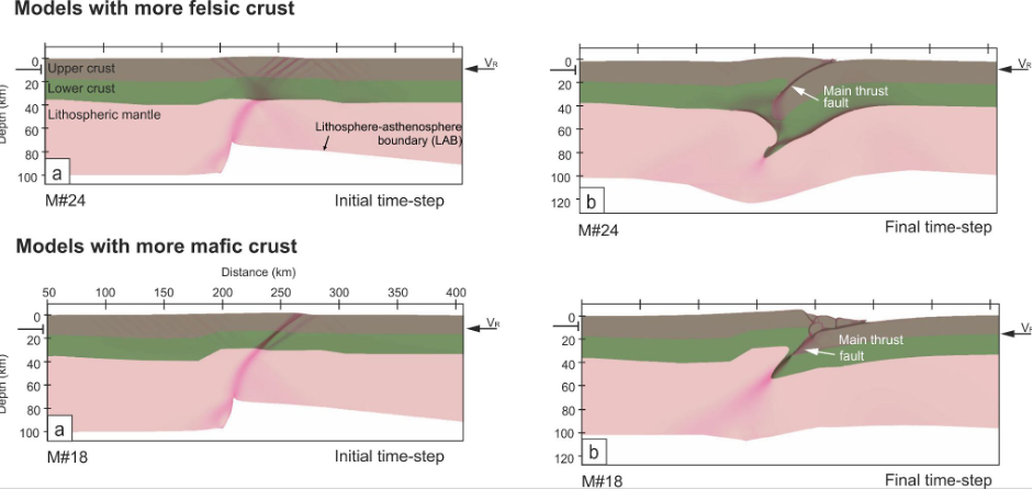
Figure 4: Model results with different composition. In the top panels, more felsic (i.e., weaker rheology) crustal composition leads to viscous flow in the lower crust. In the bottom panels, more mafic (i.e., stronger rheology) derives in shear zones cutting the whole crust. In both type of models, the asymmetric lithosphere-asthenosphere boundary (LAB) produces east-(right side of the models) directed shear zones. Figure modified from Barrionuevo et al., 2021.
These modeling results gave new insight about some of the possible factors controlling the foreland deformation style. But as with every model, there are some limitations and simplifications that are done. Namely, the absence of the subducting slab and the lack of surface processes that we did not include in our study. So this isn’t the end of the story, and there’s still work to be done!
To round up these paragraphs, I think that several unknowns about the Andean geology are still there strolling above the Andean summits. Thus we can try to understand them in the same way we try to summit a peak: step by step, enjoying the way up and not only focusing on the top. And, more importantly, with the companion of our colleagues.
If you want to go deeper into our research, below you’ll find a list of recent articles about the Andes.
Barrionuevo, M., Liu, S., Mescua, J., Yagupsky, D., Quinteros, J., Giambiagi, L., Sobolev, S. V., Piceda, C.R., Strecker, M.R., 2021. The influence of variations in crustal composition and lithospheric strength on the evolution of deformation processes in the southern Central Andes: insights from geodynamic models. Int. J. Earth Sci. https://doi.org/10.1007/s00531-021-01982-5

Darwin, C., 1846. Geological observations on South America: Being the third part of the geology of the voyage of the Beagle, under the command of Capt. Fitzroy, RN during the years 1832 to 1836. Smith, Elder and Company.

Giambiagi, L., Mescua, J., Bechis, F., Tassara, A., Hoke, G., 2012. Thrust belts of the southern Central Andes: Along-strike variations in shortening, topography, crustal geometry, and denudation. Bull. Geol. Soc. Am. 124, 1339–1351. https://doi.org/10.1130/B30609.1

Giambiagi, L., Tassara, A., Echaurren, A., Julve, J., Quiroga, R., Barrionuevo, M., Liu, S., Echeverría, I., Mardónez, D., Suriano, J., Mescua, J., Lossada, A.C., Spagnotto, S., Bertoa, M., Lothari, L., 2022. Crustal anatomy and evolution of a subduction-related orogenic system: Insights from the Southern Central Andes (22-35°S). Earth-Science Rev. https://doi.org/10.1016/j.earscirev.2022.104138

Sánchez, M. A., García, H. P., Acosta, G., Gianni, G. M., Gonzalez, M. A., Ariza, J. P., Martinez, M., Folguera, A., 2019. Thermal and lithospheric structure of the Chilean-Pampean flat-slab from gravity and magnetic data. In Andean tectonics (pp. 487-507). Elsevier.

Stelzner, A., 1885. Beiträge zur geologie und palaeontologie der Argentinischen Republik. Theodor Fischer. Berlin.