For today’s interview, it gives me great pleasure to host Dr Manfred Stähli, who will tell us about a new initiative in the field of Landslide Early Warning Systems (LEWS), which is attracting the attention and participation of researchers from many countries. This initiative is called LandAware. Manfred is a senior scientist in mountain hydrology, slope stability and early warning systems a ...[Read More]
The earthquake traffic light

Dr. Laura Gulia is a senior post-doc at the University of Bologna, Department of Physics and Astronomy. She has a strong experience in statistical seismology, seismicity analysis as well as seismic hazard and risk assessment. Recently, she investigated the spatio-temporal evolution of the earthquake size distribution throughout a seismic sequence focusing on the b-value, a parameter characterizing ...[Read More]
Stromboli: The Lighthouse of the Mediterranean
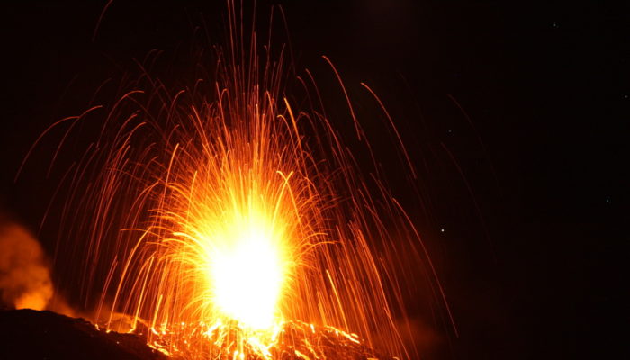
Figure 1. Stromboli night activity (Image credit: Katja Bigge. Distributed via imaggeo.egu.eu)
In the last months two paroxysmal explosive eruptions took place at Stromboli volcano: the first one, totally unexpected, on 3rd July (Video 1) that sadly cost the life of a person and the second and, currently, last one about three weeks ago, on the 28th August (Video 2). Today we try to answer a couple of questions about Stromboli and its eruptions. Are these paroxysmal eruptions common or rare ...[Read More]
Cyclone Fani: A success in weather forecast and disaster preparedness
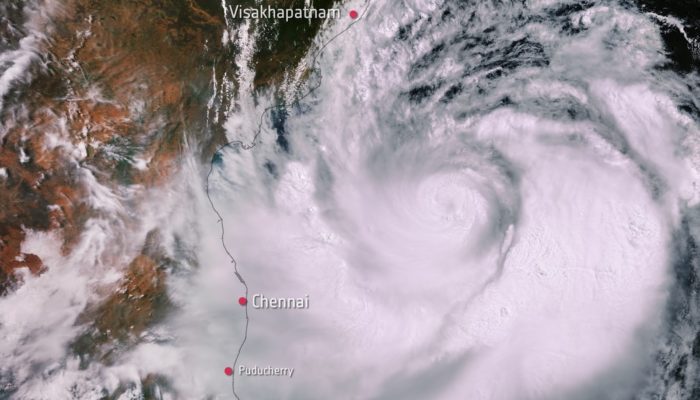
This Copernicus Sentinel-3 image captured on 1 May 2019 shows Cyclone Fani. In the image, the width of the storm is estimated to be around 700-800 km. (Image Credit: ESA - CC BY-SA 3.0 IGO)
Hurricane, cyclone and typhoon are different terms for the same weather phenomenon: torrential rain and maximum sustained wind speeds (near centre) exceeding 119 km/hour (World Meteorological Organization https://public.wmo.int/en). The terminology depends on the region (e.g. in the western North Pacific, they are called typhoons; in the Bay of Bengal and the Arabian Sea they are named as cyclones ...[Read More]