Multi-hazards are “a selection of major hazards that a country faces, and specific contexts where hazards occur simultaneously, cascadingly, and accumulatively considering the interrelationships among them”, based on the UNSDRR definition [7]. Yet, this definition raises two key questions: Where are these specific contexts located, and what characteristics make them susceptible to intersecting hazards? When considering multi-hazards and their interactions, we often look into natural hazards individually and then attempt to link their triggers and outcomes (e.g., earthquakes and their consequences). However, examining multi-hazards in the context of different geographical settings allows us to better anticipate potential interactions and their impacts in specific locations. In this post, I will briefly explore the characteristics of these specific contexts, highlighting how natural forces overlap to create multi-hazard scenarios. Through selected examples in each particular context, I will highlight how identifying and understanding these interactions can support forward-looking approaches to risk reduction.
Across the globe, various geographical settings inherently foster networks of hazard interrelationships. Among these, coastal, mountainous, volcanic, and more recently karst regions are widely recognised as multi-hazard-forming zones, each with its own distinct hazardscape, leading to complex natural hazard interactions [6]. Adapted from UNISDR (2017) [7], a multi-hazard-forming area refers to a geographic region where multiple geophysical and environmental factors—such as climate, topography, and geology—converge, creating conditions that allow hazards to occur simultaneously, cascade into one another, or accumulate over time.
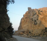
In mountainous regions (e.g. Central Europe, the Mediterranean and the Himalayas), the complex interaction of topography, climatic conditions, and geological processes makes them highly susceptible to different multi-hazard scenarios. In these regions, multi-hazard chains often follow a pattern where an earthquake or flooding triggers landslides and debris flows. These can block rivers, leading to further flooding, landslides and debris flow events. A notable example is the 2015 Gorkha earthquake event in Nepal, which triggered over 24,000 landslides, significantly compounding the disaster and contributing to a death toll of nearly 9,000 people [2].
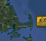
Similarly, coastal areas, which account for 4% of Earth’s total land area and host about 11% of the world’s population [1], are highly susceptible to cascading multi-hazard events. A hurricane can generate a cascade of multi-hazards by producing strong winds and storm surges, ultimately triggering flooding, mudslides, and landslides [3]. In October 2024, an event near Siesta Key, Florida exemplified a chain of multi-hazards in coastal environments when the Category 3 Hurricane Milton unleashed 46 tornadoes resulting in widespread torrential rainfall and severe flooding [5]. Recently, two clustered storms, Bert and Darragh, occurred one after another (on November 23 and December 7, 2024, respectively) across the UK, triggering flooding, landslides, and ground collapses in specific communities [7]. Such back-to-back extreme weather events are becoming more frequent, particularly in coastal regions. As climate change is expected to intensify rainfall [7], the likelihood of severe multi-hazard scenarios continues to grow in the future.

Diverse geographical settings, highlighting areas where Earth processes have the potential to overlap in time and space. (a, b) Mountainous (aerial photo of Greenland and the region of Styria, Austria); (c) Volcanic (Stromboli volcano, northern coast of Sicily, Italy); (d) Karst (an exposed outcrop of sensitive bedrock in the karst area of Val d’Orléans, France). (Image credits: Hedieh Soltanpour)
Another well-known multi-hazard-forming area is volcanic islands (e.g., the Canary Islands and Hawaii). Volcanic islands are formed by submarine volcanic activity and shaped over time by geological, environmental, biological, and human influences. A single volcanic eruption in these areas is already a multi-hazard event, creating a cascading chain of hazards (i.e., lava, lahars and pyroclastic flows, earthquakes, tsunamis) [3]. This can be exemplified by the 1985 Nevado del Ruiz eruption, which triggered glacial melting and caused devastating lahars that buried the town of Armero in Central Colombia, killing over 23,000 people [9].
The last multi-hazard-forming area I am addressing in this post is karst. Compared to the previously mentioned areas, karst terrains have received significantly less attention for reasons that are beyond the scope of this post. In these areas, water plays a crucial role in shaping the hazardscape. Many of us think about erosion on the Earth’s surface, but erosion can also occur below the surface. Over long periods, groundwater flowing through the subsurface can dissolve soluble bedrock, creating cavities and tunnels [10]. Those cavities inside the ground can be triggered by natural hazards such as floods and earthquakes. Depending on the location of the sinkhole collapses—particularly if it breaches riverbanks—this can initiate another hazard chain like further flooding. A real-world example of this scenario is the region of Orléans in France, where five consecutive days of intense rainfall led to flooding, triggered more than 100 sinkhole collapses [4].
From a disaster risk reduction perspective, it is crucial to explore and characterise multi-hazard-forming areas, identifying as many potential multi-hazard scenarios as possible. Anticipating different scenarios—whether they involve various primary hazards, potential triggering mechanisms, or complex cascading effects—enables decision-makers and disaster responders to act proactively rather than being caught off guard by unforeseen hazard interactions. Beyond policy and planning, understanding multi-hazard dynamics can also be a valuable mindset in everyday life. Here is a personal tip for hazard scientists—or anyone curious about a place’s hazardscape: take a moment to observe your surroundings the next time you visit a city or region. Ask yourself: What is the geographical setting? Is it coastal, mountainous, volcanic, a combination of these or something entirely different? Perhaps it is a low-lying delta, an arid desert or a tectonically active rift zone? Then, consider what multi-hazard scenarios could threaten this location. This simple practice enriches your perspective on landscapes and cultivates a deeper appreciation for the intricate relationships between geography and natural hazards.
References
[1] IPCC, 2023. Sections. In: Climate Change 2023: Synthesis Report. Contribution of Working Groups I, II and III to the Sixth Assessment Report of the Intergovernmental Panel on Climate Change, pp. 35–115. . Geneva, Switzerland.
[2] Collins, B. D. and Jibson, R. W. (2015): Assessment of existing and potential landslide hazards resulting from the April 25, 2015 Gorkha, Nepal earthquake sequence, US Department of the Interior, US Geological Survey Open File Report 2015-1142.
[3] López-Saavedra, M., & Martí, J. (2023). Reviewing the multi-hazard concept. Application to volcanic islands. Earth-Science Reviews, 236, 104286.
[4] Luu, L. H., Noury, G., Benseghier, Z., and Philippe, P. (2019). Hydro-mechanical modeling of sinkhole occurrence processes in covered karst terrains during a flood. Engineering Geology, 260, 105249.
[5] Mishra., V (2024, November 29). Devastating 2024 Atlantic hurricane season ends, marked by record-setting storms. UN News. Available at: https://news.un.org/en/story/2024/11/1157616. (Accessed 23 January 2025).
[6] Soltanpour, H., Serrhini, K., Gill, J. C., Fuchs, S., & Mohadjer, S. (2024). Multi-hazard susceptibility mapping in the karst context using a machine-learning method (MaxEnt). EGUsphere, 2024, 1-39.
[7] The Guardian. (2024, November 22). UK weather: Met Office warns of wintry conditions as multi-hazard Storm Bert approaches. Available at: https://www.theguardian.com/uk-news/2024/nov/22/uk-weather-met-office-warns-of-wintry-conditions-as-multi-hazard-storm-bert-approaches. (Accessed 23 January 2025).
[8] UNDRR (United Nations Office for Disaster Risk Reduction). (2017): Terminology: Hazard (last access: 26 February 2025).
[9] Voight, B. (1990). “The 1985 Nevado del Ruiz Volcano catastrophe: Anatomy and retrospection.” Journal of Volcanology and Geothermal Research, 42(1-2), 151-188.
[10] Waltham, T. Bell, F. G., Culshaw, M. G., Knez, M., and Slabe, T. (2005). Sinkholes and subsidence: karst and cavernous rocks in engineering and construction, (Vol. 382), Berlin: Springer, ISBN: 978-3-540-20725-2.