Vancouver, Vancouver, this is it!
Just a few words radioed by volcanologist David ‘Dave’ Johnston on May 18, 1980, to USGS headquarter in Vancouver, Washington State. It was 8:32 a.m., and a few hours later he lost his life during the (in)famous Mount Saint Helens eruption.
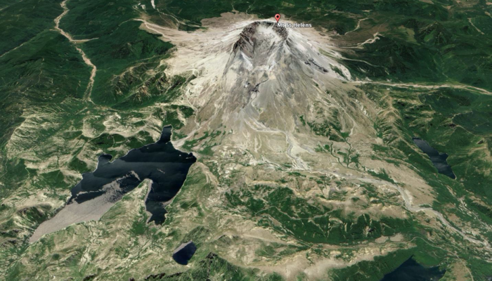
That day, exactly forty years ago, the eruption of Mount St. Helen upset the world. It all started with a collapse on the northern flank of the volcano producing the largest landslide in world recorded history and the destabilization of the volcanic system. The blast that resulted from the sudden depressurization of the northern flank devastated the surrounding landscape and killed 57 people. If all that was not enough the subsequent Plinian eruption produced tephra that spread around the world.
Let us go back first to the time just before the catastrophic event and then reconstruct the moments of the eruption.
In mid-March of 1980, a gradual increase in frequency and magnitude of earthquakes was observed signalling that the volcano was awakening once again after more than 100 years. This first increase was followed by two months of slope deformation, which accompanied magmatic migration below the surface, intense seismicity, steam and ash-rich eruptions, and the growth of an anomalous bulge on the northern flank of the volcano [1, 2]. By that time, the volcano was under strict surveillance. The monitoring team was on alert and able to keep the area evacuated. Yet, the situation seemed incredibly quiet before the events unravelled. Two geologists were flying over Mount St. Helens on the early morning of the 18th of May, about 300m above the north slope (Figure 1a). They observed minor falls of rock and ice melting, a sign that the surface of the volcano was heated, and magma was quite surficial. Then without any warning, at 8: 32: 11.4 PDT (Pacific Daylight Time) an earthquake of estimated Richter magnitude M = 5.2 shook the volcano [3, 4, 5].
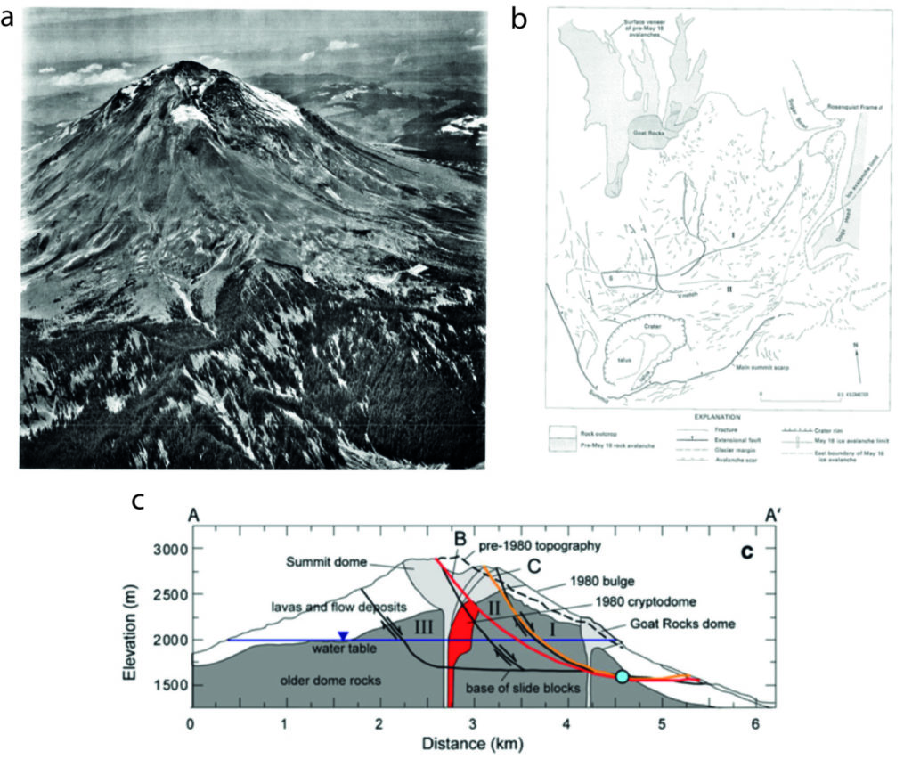
Figure 1 – a) Mount Saint Helens from the northeast on May 1, 1980, showing a bulge on the north slope east of Dogs Head, south of Sugar Bowl, and north of the main summit scarp (from Voight et al., 1981). b) planimetry of Mt. St. Helens from Voight et al. (1981). c) cross-section of the volcano slope with indicating the blocks of the volcano northern flank that collapsed (from Reid et al., 2010).
After the earthquake…
A new system of fractures formed in the summit area along the anomalous bulge. And within 10s (Figure 2) the north slope began to slide along the newly formed fracture system [6,7]. The first slide block (‘I’ in Figure 1) dipped towards the north with an angle of 50-60° that flattened with depth. This sliding block dropped sufficiently to expose more of the cryptodome, which is an accumulation of magma just below the surface of the volcanic edifice (Figure 1). The sudden exposure triggered the explosive expansion of gases in the magma and a first eruption took place [8,9,10].
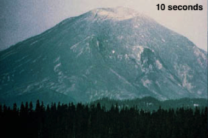
Figure 2 –10 seconds after the earthquake (photo taken by G. Rosenquist 1980)
About 26 s after the detachment, block I (Figure 3) had already dropped about 700 meters at a velocity of up to 180 km/h causing a debris flow when a second block, behind it, slid about 100 meters.
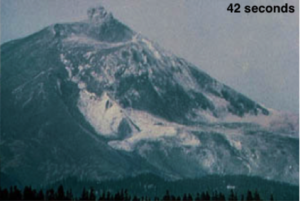
Figure 3 – slide block 1 moving (photo credit G. Rosenquist 1980)
The continuous movement of the blocks and the explosions had now thoroughly ‘uncorked’ the magmatic system of the cryptodome. Old parts of the volcanic edifice and new magmatic debris were blasted outward and the high velocity (up to 1000 km/h) [11] lateral blast cloud soon overtook the slower moving debris avalanche devastating the landscape ahead and depositing debris over 550 square km (Figure 4) [12,13]. In the meanwhile, more subsequent slope failures (slide block II in Figure 1) affected the volcanic edifice excavating it even more.
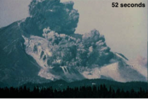
Figure 4 – the crown collapse (photo credit G, Rosenquist 1980)
Less than a minute after the start of the debris avalanche, the eruption of Mount St. Helens was in full fury (Figure 5), further enlarging the crater as smaller slide blocks fell into the vent and were blasted away. The leading front of the lateral blast now had completely overtaken the debris avalanche, the main lobe funnelled down 1-2 km wide to a distance of about 22 km, forming a hummocky deposit.
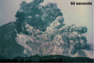
Figure 5 -the avalanche (photo credit G. Rosenquist 1980)
A Plinian volcanic eruption followed the slide-induced pressure reduction (Figure 6). The eruptive column reached more than 20 km in height. Parts of the column collapsed producing numerous pyroclastic flows on the volcano flanks. They blanketed the avalanche debris nearest to the volcanic edifice, and the combination of slope failures, debris flow and eruptive events made the volcanic summit and edifice a horseshoe-shaped amphitheatre about 2 by 4 km large. Moreover, the water produced by the melting of the ice cap together with possible liquefaction of unconsolidated material due to the earthquakes and tremor in place, mobilized the avalanche debris causing lahars disrupting the drainage system around the volcano [9].
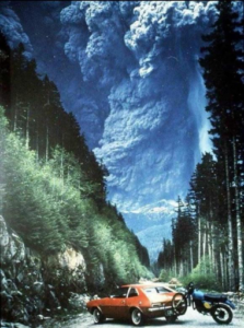
Figure 6 – Plinian eruption phase (photo taken by Frederick Lasher 1980)
Many researchers that were directly or indirectly involved during this upsetting series of events studied in depth what happened at Mt Saint Helens. Here, I had the pleasure to reference only some of the most outstanding studies that were carried out at the time. I would especially like to mention two researchers, Harry Glicken and Barry Voight for their fundamental contribution to the understanding of volcanoes and landslides dynamics. Today, the details and interpretation provided just after the event, without the aid of the modern techniques, still, stand. In some ways, their work represents a milestone for entire generations of geoscientists after them.
There is an important lesson that the event of Mount St. Helens taught me. This is that in less than a minute, our perceptions, our perspectives, and also the scientific view can change.
Remember to not forget, or as a researcher, study to understand.
Native Americans of the Pacific Northwest, who witnessed Mount St. Helens eruptions long before explorers came, called the volcano Loowit or Lawala Clough, which means ‘Lady of Fire’. Remember to not forget. I feel that our modern languages, commonly rich in many different terms, can sometimes lack words to describe the power of nature or the feeling stirred by it. I need to use my northern Italian dialect to find a specific word to indicate the emotions after a huge natural event like an eruption, an earthquake, or a massive landslide. This word is solastro, which describes the emotion of feeling mislaid, and small compared with the power of nature (an explanatory page of the word in Italian here). I think that eyewitnesses felt like this (solastro) looking at this event.
Today, Mount St. Helens is still one of the most dangerous volcanoes in the United States, and the most active of the Cascade Range, with the last eruptive phase recorded in 2008. Remember to not forget.
To conclude, it’s important to remember all the 57 people who lost their lives during the 1980 eruption and in particular Dr Dave Johnston. He was part of the USGS monitoring team and was on duty at an observation post 10 km away when the eruption killed him. His radio transmission, at the moment of the explosion, “Vancouver! Vancouver! This is it!” became popular afterwards. His work and all of the studies conducted there led to Natural Hazard management as we know it nowadays.
Figure 7 – Dr David Johnston at Coldwater II at 19:00 hours on May 17, 1980. Dave did not survive the next day’s eruption. Coldwater II would eventually be re-named “Johnston Ridge” in his honour.
References
- Lipman, P. W., & Mullineaux, D. R. (Eds.). (1982). The 1980 eruptions of Mount St. Helens, Washington (Vol. 1250). US Department of the Interior, US Geological Survey.
- Voight, B., Janda, R. J., Glicken, H., & Douglass, P. M. (1983). Nature and mechanics of the Mount St Helens rockslide-avalanche of 18 May 1980. Geotechnique, 33(3), 243-273.
- Endo, E., Malone, S. D., Noson, L. L. & Weaver, C. S. (1981). Locations, magnitudes, and statistics of the March 7 & May 18 earthquake sequence. Prof. Pap. U.S. Geol. Suru., No. 1250, 93-107.
- Endo, E., Malone, S. & Weaver, C. (1981). Summary of seismic events. Prof Pap. U.S. Geol. Stow., No. 1250, 933108.
- Malone, S. D., Endo, E., Weaver, C. S. & Ramey, J. W.(1981). Seismic monitoring for eruption prediction. ProJ: Pap. U.S. Geol. Sure., No. 1250, 803-8 13
- Voight, B. (1981). Time scale for the first movements of the May 18 eruption. Pro& Pap. U.S. Geol. Sure., No. 1250, 69986.
- Stoffel, D. B. & Stoffel, K. L. (1980). Mt. St. Helens seen close up on May 18. Geotimes 25, 16-17.
- Voight. B., Glicken, H., Janda, R. J. & Douglass, P. M. (1981). Catastrophic rockslide-avalanche of May 18.Prof. Pap. U.S. Geol. Sum. No. 1250, 347-371.
- Glicken H., Janda, R. J. & Voight, B. (1980). Cata- strophic rockslide-avalanche of May 18, 1980, Mount St. Helens volcano, Washington. EosTrans. Am. Geophys. Union 61, 1135.
- Janda, R. J., Scott, K. M., Nolan, K. M. & Martinson, H. A. (1981). Lahar movement, effects, and deposits. Prqf: Pap. U.S. Genl. Sun;., No. 1250, 461-478.
- Calder, E. S., Lavallée, Y., Kendrick, J. E., & Bernstein, M. (2015). Lava dome eruptions. In The encyclopedia of volcanoes (pp. 343-362). Academic Press.
- Moore, J. G. & Sisson, T. W. (1981). Deposits and effects of the May 18 pyroclastic surge. Pro/: Pap. U.S. Geol. Sure., No. 1250, 421-438.
- Kieffer. S. W. (1981). Dynamics of the blast on May 18. Prof Pap. U.S. Geol. Surf. No. 1250, 379400.
About the author
 Stefano Alberti is a postdoctoral scholar at Oregon State University, the USA, and a landslide and geomechanics specialist. He obtained his PhD in Earth Sciences, the curriculum in Engineering Geology, at Università degli Studi di Milano-Bicocca, Italy, in collaboration with the Kyoto University, Japan. He is an active collaborator of the Regional Glacial Survey of Lombardy (SGL), Italy. He is interested in the interplay among geological structures, the thermo-hydro-mechanical behaviour of rocks, slope instability processes on different spatial and temporal scales and their geomorphological, geohazards and engineering aspects. His research focuses on mechanisms and long-term evolution of rock slope deformation; monitoring and modelling of large landslides; laboratory rock deformation; geomorphological aspects in periglacial and glacial environments (for example, rock glacier and permafrost distribution); rockfall modelling and protection.
This post was edited by: Gabriele Amato, Valeria Cigala, Asimina Voskaki.