Today I have the pleasure to post an interview on International Research Projects. The interviewee, Dr. Cees van Westen, does not need any introduction for those who work in the field on Natural Hazards. Today, he will “speak” as the coordinator of the CHANGES project and further information can be asked directly to him if this interview will stimulate your curiosity (e-mail: c.j.vanwesten@utwente.nl, tel: +31534874263).
 Dr. Cees van Westen obtained MSc in Physical Geography from the University of Amsterdam in 1988. He joined the Division of Applied Geomorphology of ITC in 1988, and specialized in the use of Remote Sensing and Geographic Information Systems for natural hazard and risk assessment. He obtained his PhD in Engineering Geology from the Technical University of Delft in 1993, with a research on “Geographic Information Systems for Landslide Hazard Zonation”. He is working in the Department of Earth Systems Analysis, and contributes to the research theme 4D-Earth, specifically to Natural Hazards and Disaster Risk Management. Dr. Van Westen has worked on research projects, training courses and consulting projects related to natural hazard and risk assessment in many different countries. From 2005- 2015 he was Director of the United Nations University – ITC Centre on Geoinformation for Disaster Risk Management. From 2010 to 2015 he was Project coordinator of the EU FP7 Marie Curie Initial Training Network “CHANGES”
1. What can you tell about the CHANGES project? (please click here to navigate to the website)
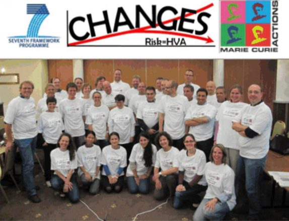
The name CHANGES stands for “Changing Hydro-meteorological Risks – as Analyzed by a New Generation of European Scientists”. This EU Marie Curie Initial Training Network project, which was running from 2011 to 2015, aimed to develop an advanced understanding of how global changes (related to environmental and climate change as well as socio-economical change) will affect the temporal and spatial patterns of hydro-meteorological hazards and associated risks in Europe; how these changes can be assessed, modelled, and incorporated in sustainable risk management strategies, focusing on spatial planning, emergency preparedness and risk communication.
2. What are the complexities in coordinating such an international project?
First of all the development of a good international consortium is a major challenge. The consortium had to consist of partners from academic and private sector, and should cover certain strategic regions in Europe. The network was very international, and consisted of 11 full partners from the Netherlands, Germany, France, Switzerland, Austria, Poland, Romania and Italy and 6 associate partners of which 5 private companies, from the UK, Spain, Netherlands, Germany, and Italy. The next complicating aspect, after the project was awarded, was to find suitable candidates that fulfilled the criteria established by the MSCA programme. Eventually the network employed a total of 17 young researchers, of which 13 were female and 4 male. They came from all over the world: New Zealand, Germany, Belgium, Slovenia, Romania, Netherlands, Italy, Myanmar, Colombia, USA, Switzerland, Macedonia, China, Iran, Moldova and Argentina. Twelve young researchers were hired for a period of 36 months, and carried out PhD research, whereas the other five were hired for 18 months and worked on the development of a web-based spatial decision support system for the analysis of changing risk. All young researchers have spent a considerable amount of time with other partners in secondments.
The large mobility of the project made it very complex to handle. The young researchers stayed generally with at least two partners for a period of time. Some of the partners were not Universities and for them also other academic partners were involved where the actual PhD defence took place. The contracts with the young researchers was for a period of 3 years, whereas in most of the cases the PhD takes more time, so it was also complex to find follow-up contracts so that all could complete their PhD, which they almost all did. Another complicating issue was the active stakeholders’ participation which required the involvement of organisations that were not partners, and who’s involvement could not be easily controlled.
3. I assume it is difficult to foresee the results of such a complex project when you first apply for a grant. Do you think you have reached the expectations you envisioned when you first applied for CHANGES? If yes, what are the main goals the project has reached in your view? If no, how could have it been improved?
Yes, this was indeed difficult to foresee in terms of the scientific results, but more easily in terms of the expected project results: helping young researchers to develop the right skills in order to become experienced researchers. As the funding in this project all went to the young researchers, and not to the salaries of the existing scientific staff, the scientific results were also obtained through the work of the young researchers. The scientific focus of the project was on a number of topics organized in five themes (work packages). The first objective was to analyse the changes in hydro-meteorological hazards that are expected as a result of environmental changes. Regional and local scale probabilistic hazard assessments for floods, landslides and debris flows were developed for four case study sites (Barcelonnette / Ubaye Valley in France; Buzau County in Romania; Fella River in Italy; and Wieprzówka catchment in Poland). The second objective was to evaluate environmental changes, triggered by global change (including climate change) and interacting with economic development, leading to changes in exposed elements at risk. The third objective was to integrate the techniques for hazard assessment with the results of the exposure and vulnerability analysis, into a platform for Quantitative Risk Assessment (QRA) using multi-hazard risk assessment techniques. The fourth objective focused sustainable risk management strategies, related to spatial planning and emergency preparedness, response and rescue activities. The outcomes were used for risk communication purposes, achieved by designing specific risk visualization and communication tools, aimed at local authorities, planning agencies, civil protection organizations, and also with a component directed to the general public. Most of the objectives that were stated in the proposal were addressed in the PhD research of the young researchers. One of the main challenges in this project was that some researchers were highly depending on the outcomes of others, and as all started at the same time, this caused difficulties for some that were further in the risk assessment and management chain.
4. CHANGES is clearly a rare if not unique project as it involved collaboration, coordination and focus across many different institutions and topics. How does this impact the development of a young researcher?
As the aim of the programme was to support the scientific development of young researchers, the network organized a large series of training events in which also participants from outside of the network were invited. This resulted in a total of 6 professional skill courses, 6 technical skills courses and 5 topical workshops. The project partners and young researchers actively collaborated with other Universities, research projects, NGOs and international organisations. Scientific output of the project was in the form of peer reviewed journal articles and numerous conference papers and abstracts. One of the main outputs of the project was the development of an internet-based Spatial Decision Support System called RiskChanges with the aim to analyse the effect of risk reduction planning alternatives and possible future scenarios related to climate change and landuse changes on reducing the risk now and in the future, and support decision makers in selecting the best alternatives. The project partners and young researchers actively collaborated with other Universities, research projects, NGOs and international organisations. The results of the project were all made available through the project website (http://www.changes-itn.eu/). At the end of the project the International Conference on the Analysis and Management of Changing Risk for Natural Hazards was organized to present and discuss research results in the above mentioned fields. The conference was held on 18 and 19 November, in Padua, Italy.
5. How frequent are this type of projects? Are you planning for applying for something similar in the near future?
Such large EU networks are certainly not frequent, but are also not impossible to obtain. The competition for such projects is very large though. We were told that there is less than 2% change for such a proposal to get funded. This is also due to the fact that there are no specific thematic call. It is possible to submit a proposal on many different topics, but the selection procedure is very tough. The programme is now called Marie Skłodowska-Curie Innovative Training Networks. It has regular calls, generally once a year. The proposed research training or doctoral programme should respond to well-identified multi- and interdisciplinary needs in scientific and technological research areas, expose the researcher to different sectors, and offer a comprehensive set of transferable skills (such as entrepreneurship and communication). The private sector involvement has to be very significant. Before the CHANGES project most of the partners were also collaborating within a previous network, called Mountain Risk, which was coordinated by Jean-Philippe Malet of the University of Strasbourg. After the Changes project we also tried to get a follow-up project with another partner taken the lead, but this was not funded. I am personally not considering to submit a new proposal in the coming years, as it is a lot of work to coordinate it.