The Asian continent has fascinated the world for at least 3,000 years with its music, food, and discoveries, as well as its breathtaking landscapes. Most of these incredible landscapes are formed by mountains that can be considered geologically “recent” (such as the Cenozoic formation of the Himalayas). However, there are also ancient terrains, pre-dating the Mesozoic, that pose intriguing questions for geoscientists. Today, Professor Yu Wang (王瑜) from the Institute of Earth Sciences (Beijing) at the Chinese University of Geosciences (中国地质大学(北京)) will take us on a geological tour through the history of one of these ancient terrains: the North China Craton!

Yu Wang (王瑜) is a professor of structural geology, tectonics, and tectonochronology at the Institute of Earth Sciences, China University of Geosciences (Beijing), China. His current research involves intracontinental tectonics and orogens. He completed his PhD in tectonics at the Chinese Academy of Geological Sciences, Beijing, in 1994.
This portion of the Chinese landmass is located between the Yangtze Craton (also known as the South China Craton) and the Central Asian Orogenic Belt—a giant tectonic domain—and hosts the Cenozoic basins of China’s northern coast (Figure 1). The formation, evolution, and destruction of the North China Craton (NCC) are highly complex and remain a subject of active debate, as modern geoscience continually brings forward new data and theories regarding the region. Now that we have a brief introduction, let us examine it more closely.
Several proposed models
The lithospheric thinning of the North China Craton (NCC) by ~100–120 km was initially deduced from early Paleozoic kimberlite intrusions (~480 Ma) in eastern China (Figure 1). Therefore, the destruction of the NCC has been attributed to multiple cycles of delamination associated with magmatic ascent, rifting, and extension. Typically, cratonic destruction was considered to have occurred predominantly around 130–120 Ma, resulting from multiple magmatic intrusions and coinciding with the formation of many metamorphic core complexes. Driven by this timeline, different geodynamic hypotheses have been put forward, such as cratonic delamination and the subduction rollback of the paleo-Pacific plate.
Following a comprehensive review of the NCC’s tectonic evolution, the current consensus is that the so-called destruction of the craton was actually a long-term evolutionary process in the region. Age data indicate distinct structural and magmatic stages occurring at ~1600–1500, 1300–1100, 445–315, 270–200, 170–155, 130–110, 75–65, and 25–20 Ma. These distinct stages correlate directly with episodes of basin formation, continental uplift, and lithospheric collapse.
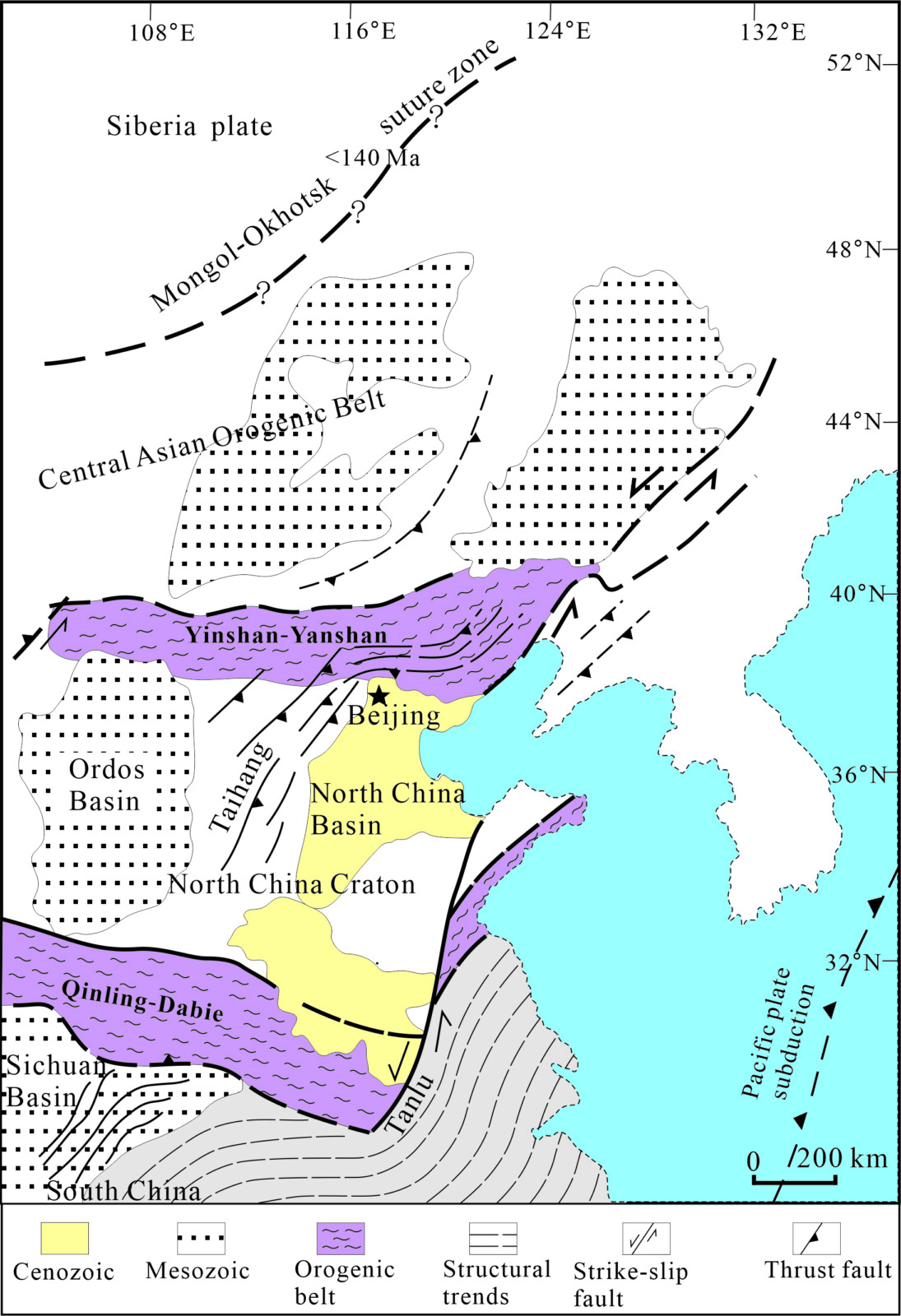
Figure 1: Regional tectonics of northern eastern China (Wang et al., 2011). North China Craton is between the two E-W orogenic belts.
1. Cratonization and Decratonization
The NCC formed prior to ~1.8–1.9 Ga. Although its oldest Archean rocks date back to 3.8 Ga, the majority of its crustal growth occurred between 2.9 and 2.5 Ga. From 1.8 Ga onwards, subsequent sedimentation covered the entirety of the craton. During the Mesoproterozoic (at ~1.6–1.4 Ga), following the break-up of the Columbia (also known as the Nuna) supercontinent, intense magmatic activity took place, resulting in the formation of a major unconformity along the northern margin of the NCC. Similar tectonic features are observed at the southern margin, evidenced by records of volcanic eruptions dating to ~1.6–1.5 Ga.
From 1,300 to ~445 Ma, the cratonic crust remained relatively stable, as indicated by the shallow marine sediments covering the basement rocks. This earlier stage of marginal rifting and extension can be characterised as a period of ‘proto-destruction’, serving as a prelude to the craton’s later, more severe decratonization.
2. De-rooting of the NCC (~445–315 Ma)
A sudden shift in sedimentary sequences during the Late Ordovician reflects a period of significant regional uplift, which persisted until the Middle–Late Carboniferous. Although this uplift event affected the entirety of the NCC, it was most pronounced in the central region, with absolute ages constraining the tectonic activity to between 445 and 315 Ma. Stratigraphic and petrological evidence supports this timeline. For instance, early Paleozoic kimberlite intrusions (488–465 Ma) predate the formation of the zircon-bearing bauxites associated with the uplift. Because these kimberlites indicate an intact lithospheric thickness of approximately 200 km during the early Paleozoic, researchers infer that the NCC only became detached from its lithospheric root subsequently (around 480–460 Ma). Over time, the lithosphere thinned by as much as 100 to 120 km. This extensive continental uplift was most likely driven by the craton detaching from its deep root, resulting in a fundamental loss of tectonic stability.
3. Marginal reactivation and subsequent orogeny (~320–200 Ma)
Along the northern and southern margins of the NCC, episodes of deformation and magmatism occurred between ~320 and 200 Ma (Figure 2). Petrology suggests that these magmatic rocks originated from the partial melting of pre-existing gneiss and granulite. At the northern margin, E-W trending ductile shear zones accommodated this strain, producing prominent southward-verging inclined and recumbent folds. This indicates that the de-rooting of the craton likely initiated at its margins before progressively migrating towards the cratonic interior.
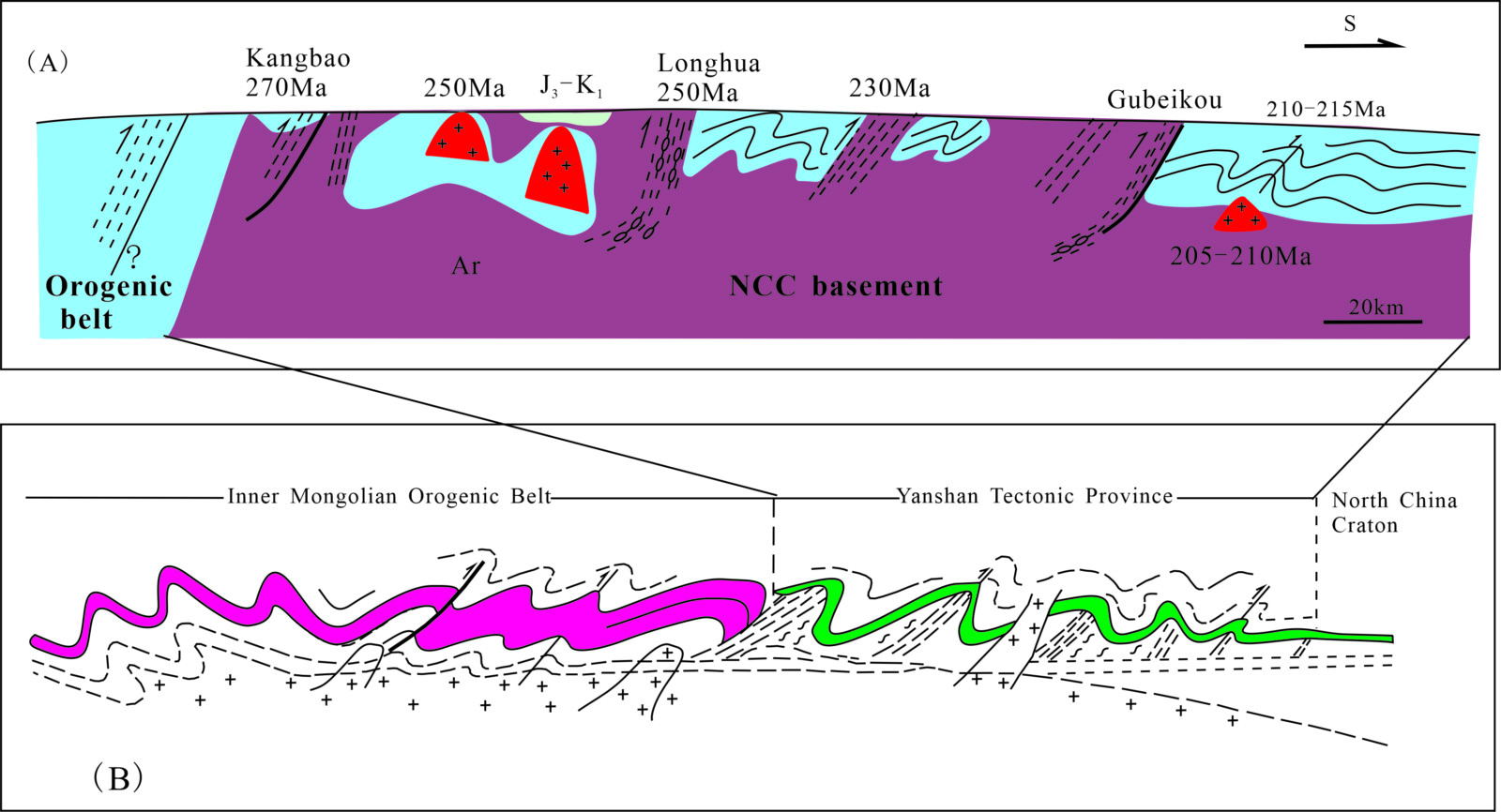
Figure 2: (A) Combined structural–chronological section from north to south portion of NCC. (B) Kinematic features of the Inner Mongolian Orogenic Belt southward to the North China Craton (Wang et al., 2013).
Ultimately, these marginal areas lost their inherent cratonic stability and fluid-depleted characteristics. Having shed their cratonic signature, they transitioned entirely into active orogenic belts. Following this stage of marginal reactivation, the stable, rigid core of the North China Craton was significantly reduced in size and continued to progressively shrink over time.
4. Tectonic transformation and complete reactivation (170–155 Ma)
Beginning at ~170–165 Ma, a fundamental transformation of the regional tectonic domain completely reconfigured the eastern Chinese landmass (Figure 3). During this period, the structural regime of the NCC underwent a major kinematic shift, transitioning from an E–W trend to a N-S trend. Correspondingly, the overarching tectonic setting shifted from an association with the Eurasian domain to being governed by the western Pacific plate boundary.
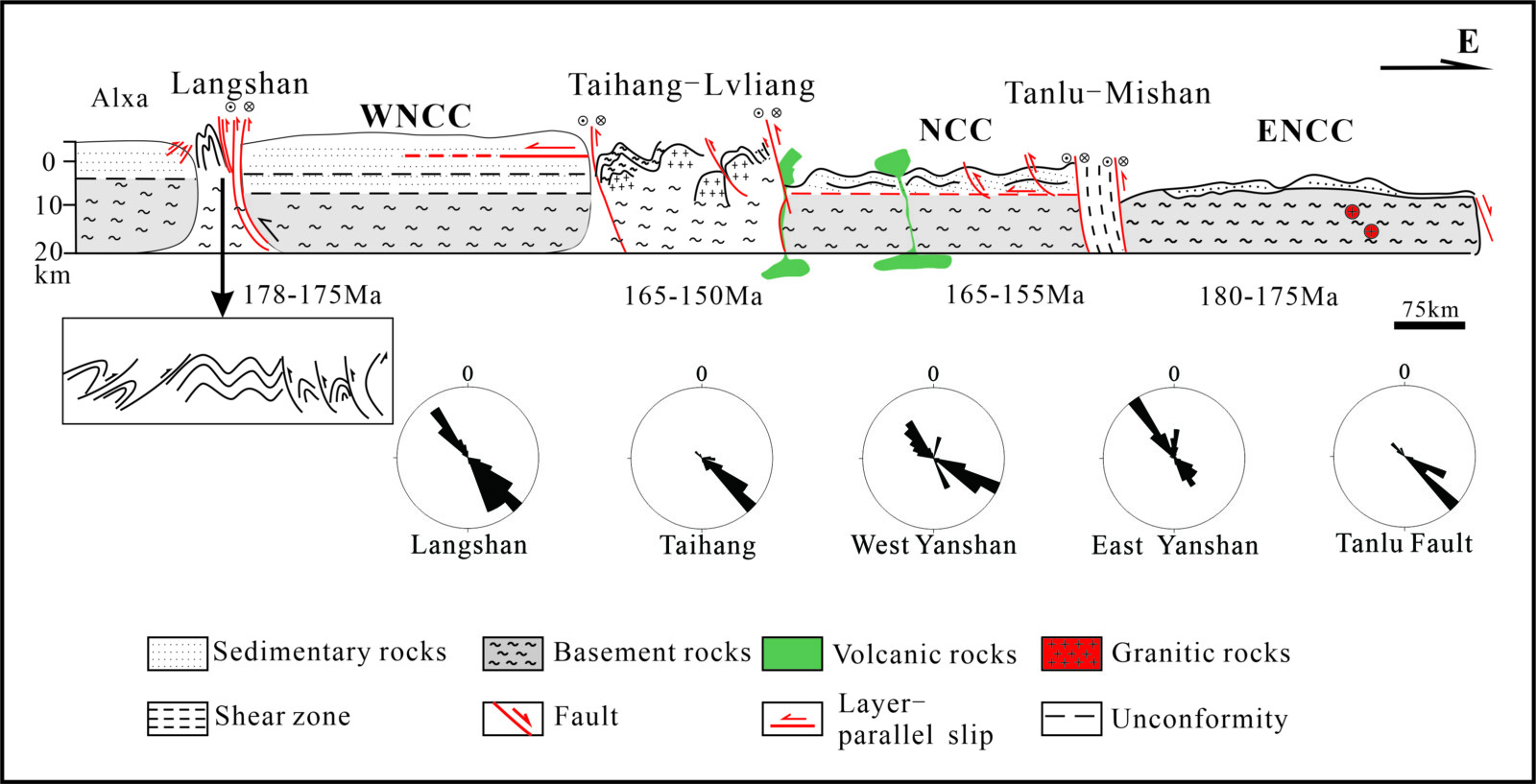
Summary lithological profile and structural cross-section of the North China Craton during the 180–150 Ma interval (Wang et al., 2017). This section represents an E-W slice of Figure 1 (ENCC: East North China Craton; WNCC: West North China Craton).
Deformation during this transitional stage was both intensive and widespread. Lower crustal materials were exhumed to the surface, accompanied by substantial volcanic activity and crust–mantle interaction, predominantly localised within regions undergoing active tectonic transformation. Continued orogenesis at the cratonic margins resulted in a further reduction in the size of the stable cratonic core. Ultimately, under the influence of the western Pacific tectonic setting, the NCC transitioned entirely into an active continental margin
5. Removal of the lithospheric root: the North China cratonic margin (130–110 Ma)
It has been suggested that the main period of destruction of the NCC was at ~130–110 Ma. Studies indicate that deformation, magmatism and basin formation during this period represent strong evidence for the destruction of the North China craton. Between 130 and 110 Ma, de-rooting of the craton had occurred along the northern margin, and likely also the southern margin. Either lithospheric de-rooting must have occurred, or a new lithospheric root must have grown. There is no evidence of regional extensional tectonics at this time. The rollback of the Western Pacific Plate may have been controlled by the extension of a large area of Eastern Asia. The best explanation so far is that mantle extrusion occurred across the entire Eastern Asian continent.
6. Partial removal of continental lithospheric mantle (75–65 Ma)
This stage of deformation only affected the eastern segment of the northern North China Craton, and in the northeast and southeast of eastern China. High-angle normal faults define the boundaries of the eastern part of the NCC, or the boundaries of the North China Basin. At 75–65 Ma, the Taihang Mountain Belt underwent rapid uplift and exhumation, and the eastern China continental margin opened. Since then, the North China continental lithospheric mantle changed as the oceanic lithospheric mantle feature.
7. Deformation and differential mountain uplift (25–20 Ma)
Deformation and volcanic activity during this stage occurred in localised areas, generally along the north of the North China Basin. Basaltic activity occurred along the eastern Asian continental margin and in the interior. Later rifting, up to eight million years younger, took place at the margins of the Ordos Basin. At this stage, the western Pacific plate was being subducted westward beneath the eastern Asian continent. The South China Sea opened up during this time, while the Japan Sea began to close. Collision-related uplift of the Tibetan Plateau controlled this deformation within the Chinese continent, including volcanic activity at 24–20 Ma. The stable craton relict comprised the southern part of the North China Basin, the centre of the Ordos Basin and the Shanxi Plateau
The Challenges Persist
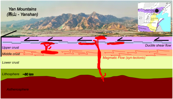
In summary, the lithosphere remained thicker than 150–170 km under most of the NCC, and the lithosphere was thinnest along the northern Taihang Mountain Belt and the Bohai Bay Basin, being less than ~75 km. The total amount of lithospheric thinning was ~120 km, given an original thickness of ~200 km. The processes of destruction of the NCC have been suggested and discussed, but there are still many unknowns: whether cratonic stability was lost in a single event or over time, and whether deformation was overprinted by subsequent thermal events or simply by plate subduction. In addition, it is unclear whether intracontinental deformation resulted from asthenospheric upwelling, continental marginal subduction and collision, or a combination of these processes (Figure 4). Besides, the question of whether a craton that has lost its stability can still be considered a craton, should be reconsidered.
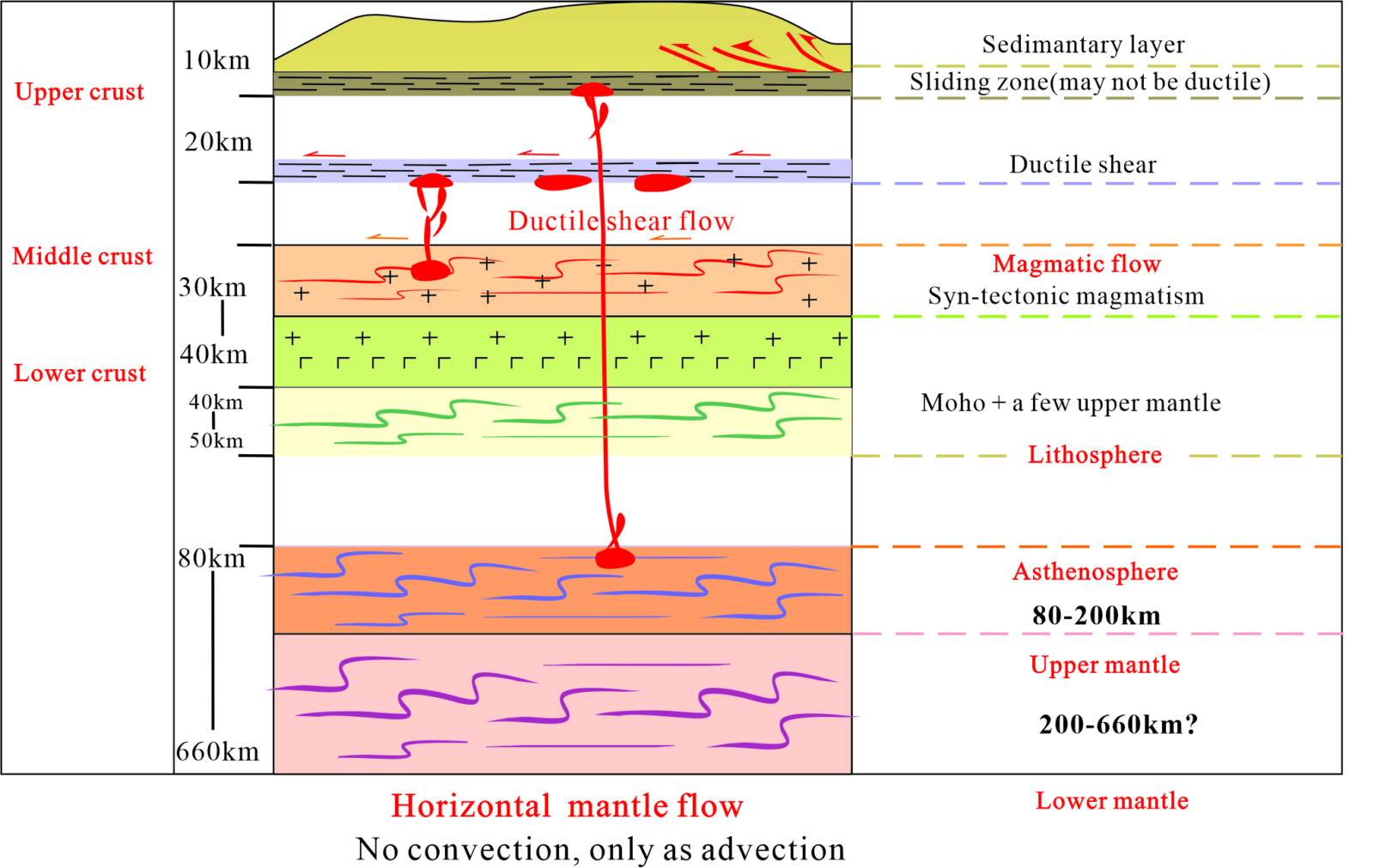
Frameworks and mechanisms at the crust, lithosphere, and mantle levels, based on the case of North China Craton destruction (Wang, 2025). Layered crustal shear, mantle shear, mantle flow, and syn-tectonic magmatic flow from continental margins to interiors are also involved.
References:
  Wang Yu, Zhou Liyun and Li Jinyi, 2011, Intracontinental superimposed tectonics — A case study in the Western Hills of Beijing, eastern China. Geological Society of America Bulletin, 123, 1033-1055.
  Wang Yu, Zhou Liyun, Zhao Lijun, 2013, Cratonic reactivation and orogeny: An example from the northern margin of the North China Craton. Gondwana Research, 24,1203-1222.
  Wang, Y., Zhou, L. Y., Luo, Z. H., 2017, Kinematics and timing of continental block deformation from margins to interiors. Terra Nova, 29, 253-263.
  Wang, Y., 2025, Intracontinental tectonics and orogeny. Cambridge Scholars Publishing, pp. 435