This weeks post is all about the importance of boundaries. Plate boundaries that is. Jean-Christophe Wrobel-Daveau and Graeme Nicoll tell us why we should care where plate boundaries are and how they evolve through time, when attempting to reconstruct past plate motions.
Global plate tectonic models are an incredible way to synthesise geological knowledge to gain both direct and indirect insight into the history of the Earth and the processes operating upon it. They also offer a valuable framework within which to contextualise other types of data, ultimately leading to predictions of, for example, past climates, sedimentation and deformation process and the location of natural resources (Fig. 1) (Lang et al., 2020). In industry, we are interested in putting data into its original context. Ideas are often generated and then tested by looking at high resolution models of the paleo-world and then validated in present-day (often at depth by the drill bit). Understanding how geological processes work at a variety of scales (both in space and time) as well as examining data in context is key to making predictions and extrapolating ideas into areas where limited information may be available. The building and updating of geodynamic models are a foundational piece in this workflow for us.
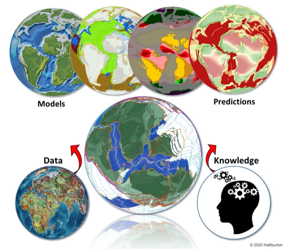
Fig. 1: Building a robust plate tectonic model from data and regional knowledge is just the starting point for understanding the wider Earth system, enabling advanced predictions of tectonics, sedimentation, climate and the occurrence of natural resources through time and space. (Lang et al., 2020).
We’ve all seen them. Those hypnotic animated reconstructions where continents dance across the surface of Earth until reaching their present-day positions. As captivating as they are, they often leave us with the impression that continental masses are the stars, with oceans between them simply appearing as a result of their movements. Continents rule, and plate boundaries simply appear and disappear around them. Whilst many plate models thus far have focused on the reconstruction through time of the present-day large-scale continental blocks, what about the evolution of the plates they are sitting on? As Hochard (2008) puts it, “the results are closer to continental drift than to plate tectonics”. The Earth’s crust can, however, be broken down into many geodynamic units (GDUs – individual crustal elements that have a unique and distinct geological history). These individual GDUs can be amalgamated into terranes or continents and move together through geological time. While the movements of these terranes and continents are very important, we must also consider plates in their entirety as well as the boundaries between them (e.g. mid-ocean ridges, sutures, rifts, subduction zones) (Fig. 2).
Constructing a geodynamically consistent, global plate boundary network through the Phanerozoic or into deep time is a time consuming and technical challenge. Here, we explore why plate tectonic boundaries should be an important component of plate tectonic models, what are the challenges related to their creation and how we can, as a community, work at developing ever improving workflows to streamline this complex process.
Rethinking “dynamic” plate boundaries
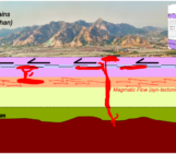
Tectonic plates often comprise both continental and oceanic lithosphere (Fig. 2). Oceans open and close, plates (not just continents!) separate and amalgamate. Tectonic ‘plates’ are, therefore, a time-dependent notion. Plate boundaries evolve, and as they do plate boundary forces change. These changes affect how plates are moving which, in turn, influence the evolution of plate boundaries themselves…and we are back to the beginning of this sentence.
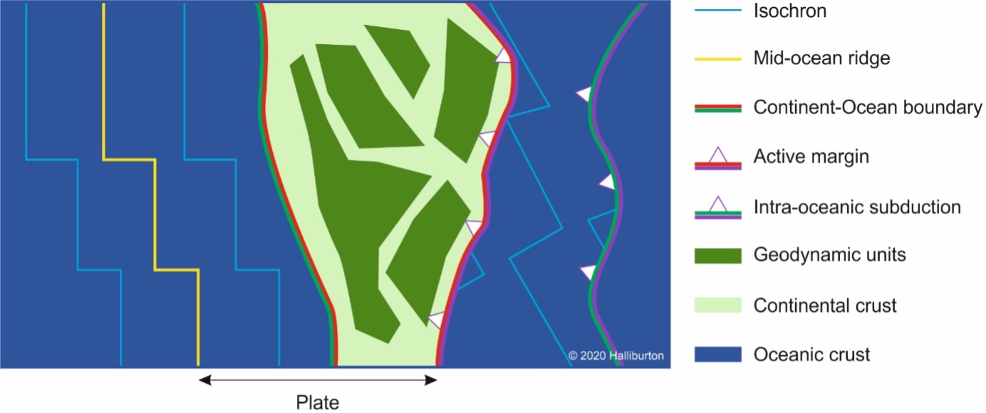
Fig. 2: Schematic representation of plate model components including geodynamic units, continents/terranes and plates. The linework is composed of plate boundaries (e.g active margin, and mid-ocean ridge), continent-ocean boundaries (e.g. active margin, and passive margin) and other important features (e.g. isochrons). Note that a plate can be composed of a continental and an oceanic domain.
Plate modellers can use this to their advantage. The concepts of ‘dynamic plate boundaries’ (Stampfli and Borel, 2002; Hochard, 2008) or a ‘dual control approach’ (Vérard, 2018) embrace this notion of ever evolving plate limits between essentially-rigid plates. This approach relies on the modelling of “key [continental] assemblies” at given steps of the Earth’s evolution and the creation of consistent geodynamic scenarios to link them (see Vérard, 2018). As such, plates are considered in their entirety and ensuring that their boundaries evolve following a geodynamic rulebook that guarantees that, at any point in time, the model is self-consistent. For instance: triple junctions must be stable or active margins can evolve into collisional zones (McKenzie and Morgan, 1969).
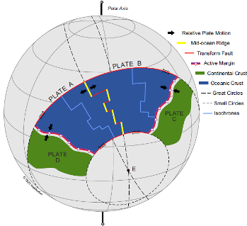
Fig. 3: Construction of plate boundaries between plates A and B, using a calculated Euler relative stage pole (E). Mid-ocean ridge segments follow great circles passing through E. Transform faults follow small circles centred on E (Wrobel-Daveau et al., 2020).
Once the kinematic evolution of continents and terranes between key assemblies is established, plate boundaries can be generated using the relative stage rotation poles between pairs of plates (Fig. 3). This “dynamic plate boundaries” approach imposes additional geometrical controls, resulting on reconstructions that better adhere to the core of the plate tectonic theory (McKenzie and Morgan, 1969). Unfortunately, the process remains largely manual and calls for more automation to increase efficiency and modelling accuracy, but it is a rigorous and valuable effort that results in the representation of “true” plate tectonics (as opposed to continental drift). This additional effort has enabled the team in Halliburton to construct the Neftex plate model, in turn using it as the foundational stone for the development of a range of Earth system science code, from digital elevation models, source to sink relationships and climate models of the entirety of the globe (Fig. 1).
Looking ahead
Automated plate paleo-boundary creation is already being developed using machine learning techniques to better integrate numerous sources of information and their uncertainties, by our team at Halliburton in collaboration with academic partners. Recent advances in the generation of closed plate boundaries (Matthews et al., 2017; Merdith et al 2021) and the reconstruction of consumed oceanic seafloor (Williams et al., 2019; Karlsen et al., 2020) get our community closer to a solution. Full integration of all of these within a “dynamic plate boundaries” approach and its application to a wider variety of geodynamic contexts are still to come.
Further Reading:

In recent articles for Exploration Insights Magazine, the authors of this week's post discuss in more detail the development of plate tectonics and how plate boundaries progressively became a component of plate tectonic models.

Hochard, C. (2008). GIS and Geodatabases Application to Global Scale Plate Tectonics Modelling. Institut de Geologie et Paleontologie, Universite de Lausanne, Switzerland.

Karlsen, K.S. et al. (2020). A tracer-based algorithm for automatic generation of seafloor age grids from plate tectonic reconstructions. Computers & Geosciences, v. 140, p. 1-9.

Lang, C., J.-C. Wrobel-Daveau and G. Nicoll (2020). Plate Tectonic Models in Exploration. Exploration Insights Magazine, v. 5, p. 20-27. Head, R. & Simmons, M. (eds.) 2021. Exploration Handbook, Halliburton, e-book, ISBN 978-1-9160054-2-6.

McKenzie, D.P. and W.J. Morgan (1969). Evolution of Triple Junctions. Nature, v. 224, no. 5215, p. 125-133.

Matthews, K.J. et al. (2016). Global plate boundary evolution and kinematics since the late Paleozoic. Global and Planetary Change. V. 146, p. 226-250.

Merdith, A.S et al. (2021). Extending full-plate tectonic models into deep time: Linking the Neoproterozoic and the Phanerozoic. Earth-Science Reviews, v. 214, p. 1-44.

Stampfli, G.M. and G.D. Borel (2002). A plate tectonic model for the Paleozoic and Mesozoic constrained by dynamic plate boundaries and restored synthetic oceanic isochrons. Earth and Planetary Science Letters, v. 196, no. 1-2, p. 17-33.

Vérard, C. et al. (2015). Geodynamic evolution of the Earth over the Phanerozoic: Plate tectonic activity and palaeoclimatic indicators. Journal of Palaeogeography, v. 4, no. 2, p. 167-188.

Vérard, C. (2018). Plate tectonic modelling: review and perspectives. Geological Magazine, v. 156, no. 2, p. 208-241.

Williams, S. et al. (2021). Reconstructing seafloor age distributions in lost ocean basins. Geoscience Frontiers, v. 12, no. 2, p. 769-780.