It is my pleasure to interview the 2023 EGU Sergey Soloviev Medalist Dr Peng Cui, Professor at the Institute of Geographical Sciences and Resources、Institute of Mountain Hazards and Environment, Chinese Academy of Sciences (CAS), known for his work and commitment to understanding geohazards, especially earthquake-induced hazards. He has dedicated his life to understanding how to minimize disaster risk. Over his vast research career, he has worked along different mountain ranges globally and felt compelled to do something for the people living in the mountainous regions, who are constantly threatened and endangered by mountain hazards. He understood that disaster risk reduction is a call from society and the times we live in and he dedicated himself to this field for over 30 years.
Hello Dr Peng Cui, thank you for your time!!
1) Can you tell us more about your research? What has shaped your research interest over the years?
My research mostly focuses on geo-hazards, understanding the formation and evolution of debris flow, earthquake-induced geohazards, and multi-hazard chaining effects. My involvement with mountain hazards all started when I was an undergraduate student and had the chance to attend a presentation by Professor TANG Bangxing from the Institute of Mountain Hazards and Environment at the Chinese Academy of Sciences. His talk sparked my interest in debris flow, a topic that is frequently associated with natural disasters. This convinced me that someone needed to work on finding practical solutions to these issues. That’s why I decided to become Professor Tang’s master’s student and then pursue a Ph.D. in debris flows under the guidance of Professor GUAN Junwei. After finishing my Ph.D., I had the chance to conduct my Post Doctorate in the Geography Department of King’s College London with Prof. John Thornes, who brought me to the research frontier and sense of international collaboration
I have developed several disaster risk assessment methods and monitoring systems to support efficient disaster reduction and established an initiation model that revealed the mechanism of debris flow inception (Figure 1). Moreover, I explained the debris flow amplification mechanism due to the cascade collapse of channel blockage and the material transport of flash floods and debris flow. This helps understand their impact on riverbed change and disaster-inducing mechanisms.
After the Ms 8.0 Wenchuan Earthquake, I focused my research on secondary hazards induced by earthquakes, such as landslides, dammed lakes, debris flow, and flash floods in the earthquake-affected area. This work revealed the distribution, regional characteristics, formation, and evolution mechanisms, especially the cascading and chaining effect between those hazards. I established the post-earthquake flow rate estimation method of mega-debris flow and quantified the influence of earthquakes on mountain hazard-fostering conditions. To consolidate my work, I published the book “Formation Mechanism and risk control of mountain hazards in the Wenchuan earthquake region”.
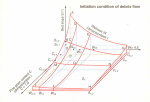
Figure 1: Debris flow Initiation Model. (Image Credit: Dr. Peng Cui)
To meet the needs of disaster risk reduction, I developed a multi-temporal and spatial disaster risk assessment method that works at the global, regional, local, and engineering scales. My team designed a simulation system for the formation-movement of flash floods, debris flows, and their cascading effect and established the method for quantitative disaster risk assessment based on their dynamic process. Based on this model, we delivered the multi-scale disaster risk assessment of the Silk Road region and the Sichuan-Tibet transportation corridor and published the Atlas of Silk Road Disaster Risk.
I proposed mass-control and energy-dissipation disaster mitigation theory and was able to successfully mitigate geohazards in more than ten towns in western China, such as Jinchuan in Sichuan. To protect the World Heritage Site, I proposed the design concept of disaster mitigation engineering and landscape coordination and developed new technologies such as source area management and water filtration structure to control debris flow in the UNESCO site, Jiuzhaigou.
2) Your research on “assessing the vulnerability of mountain highways to debris flow” is very fascinating. Can we apply a similar assessment to other vulnerable mountain highways or do the highways need to meet certain stands to be assessed?
China is a mountainous country, with about two-thirds of its territory consisting of hills and mountains. Mountain highways are the lifeline for the development of mountainous areas. Accurately recognising the disaster risk of mountain highways is essential to ensure mountainous areas’ social and economic development.
As we know, quantitative vulnerability assessment of mountain highways is crucial for conducting risk assessments. The study proposed a new integrated model of highway vulnerability based on the environmental sensibility, structural properties, and functional effects of the highway infrastructure and the exposure probability and quantity of movable elements at risk. This proposed method can be a pertinent guide for route selection, road rehabilitation, and hazard mitigation of highways affected by debris flows in mountainous regions. We applied this method to the Sichuan-Tibet Highway and Karakoram Highway in Pakistan and delivered the highway vulnerability map and the risk map subject to debris flow.
This method can also be applied to vulnerable mountain highways affected by geohazards, such as landslides. However, the assessment criteria and indicators may vary depending on the hazard characteristics, road conditions, and environmental factors. Therefore, it is important to tailor the assessment method to suit each highway project’s specific context and objectives.
3) I was fascinated by your research on the Wenchuan earthquake. Is there any intersection between Mountain Hazards and earthquakes? Can you talk about an earthquake or region where you applied risk assessment?
I worked on the earthquake and secondary disaster risk assessment for the 2008 Ms8.0 Wenchuan, the 2013 Ms7.0 Lushan, the 2015 Ms7.6 Nepal, and the 2017 Ms7.0 Jiuzhaigou earthquakes. Earthquakes can trigger a variety of mountain hazards, including landslides, rockfalls, avalanches, and debris flows. There is a very close relationship between mountain hazards and earthquakes.
The shaking caused by an earthquake can cause loose rocks and soil to become unstable and lead to landslides or rockfalls. Earthquakes also generate a large amount of loose solid material, creating rich material conditions for the formation of debris flows. For example, in the 2008 Wenchuan earthquake, the loose solid material produced by landslides and slope failures in the earthquake-stricken area reached 28 × 108 m3, providing a rich material foundation for long-term debris flow activity. Significant changes in the micro-topography of the drainage basin, severe channel blockages, and altered surface water infiltration, runoff, and convergence conditions all favour erosion and peak formation. These drastic changes in basin conditions constitute the most favourable combination of conditions for debris flow formation.
The main characteristics of post-earthquake debris flow activity are an increase in the number, size, and frequency of debris flows, a decrease in the critical rainfall intensity, and the development of viscous debris flows. The high frequency and mass occurrence of debris flows after earthquakes are significant. The bulk density of debris flows increases by about 10% to 30%, and the flow volume generally increases, with the scale roughly increasing by about 50% to 100%.
Therefore, it is important to consider the potential for mountain hazards when assessing earthquake risk in mountainous areas. Understanding and preparing for the potential hazards can help reduce the risk of damage and loss of life during and after an earthquake.
4) Can you talk about your patent ‘Debris flow hazards dynamic early warning method’ and its applications?
To monitor and early warning of debris flow formation and evolution at the watershed scale, the method involves a multi-step monitoring process that enables the identification of potential debris flow hazards and provides timely and accurate warnings (Figure 2).
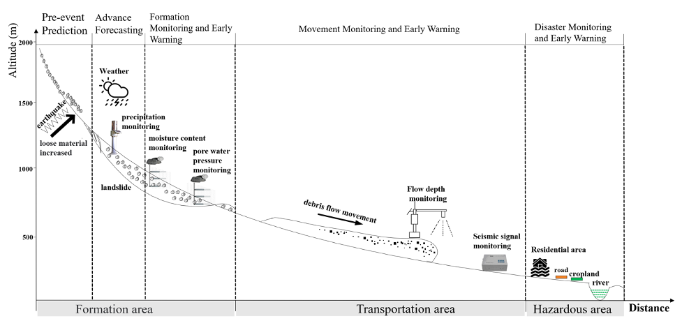
Figure. 2 Debris flow Early Warning System. (Image Credit: Dr. Pen Cui)
The proposed method is based on the principle of early prediction, impending warning, event warning, and risk warning. To achieve stepwise early warning, the debris flow process is divided into four stages: pre-rainfall, post-rainfall, pre-debris flow formation, and debris flow movement (Figure 2). The monitoring of debris flow formation is conducted by closely observing changes in water and soil parameters. During the evolution process of the debris flow, changes in dynamic parameters such as water level, flow velocity, total pressure, seismic signals, and video are closely monitored. By monitoring these parameters and changes, the method provides different levels of early warning throughout the debris flow’s entire formation and evolution process. This approach offers a comprehensive and effective method for debris flow monitoring and early warning.
Recently, my team developed a data-driven and process-based system for mountain torrent and debris flow early warning and risk forecasting. Our system monitors hazardous conditions and real-time meteorological data to identify watersheds with high susceptibility to mountain hazards. Once these watersheds are identified, the system simulates the formation and movement of hazards, capturing various characteristics such as debris flow scale amplification and flash flood erosion. We then assess the risk of mountain hazards based on the entire disaster formation-movement-deposition process. What sets our system apart from traditional early warning systems is that it is fully data-driven and process-based, requiring minimal human intervention. This enables us to provide more accurate early warning information, and our risk forecasting can better support disaster response planning for government agencies. Currently, we are conducting system trials in Liangshan Prefecture, Sichuan Province of China. In 2022, the system captured 15 debris flows and 52 flash flood events, delivering early warning information to residents and government agencies. The accuracy of our system is over 79%, significantly improving the disaster resilience of the mountainous region.
Edited by Asimina Voskaki and Paulo Hader