Coastal regions have always been at risk from natural hazards, but now, there’s an added layer of complexity. Earthquakes, which cause the land to move up or down, can significantly affect sea levels, especially in regions already experiencing the effects of climate change. Earthquakes can alter coastlines in ways that we’re still trying to understand, and it’s clear that tectonically active areas are the most affected. One key factor in these changes is Vertical Land Motion (VLM), which directly impacts how sea levels behave. In this post, we’ll explore how earthquakes, through their influence on VLM, interact with rising sea levels and discuss the challenges these combined changes pose to coastal communities and the strategies being developed to adapt and mitigate their impact.
What Is Vertical Land Motion?
Vertical Land Motion (VLM) is caused by the movement of land either vertically up (upliftment) or vertically down (subsidence) and can be attributed to natural, anthropogenic, and the combined effects of both factors [1]. Recently, there has been increased focus on subsidence because of its link to sea-level rise. Subsidence can happen immediately after an earthquake or gradually over time, both of which have significant effects on the coastline [2].
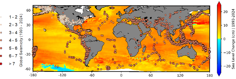
Global seismicity (1993-2024) and sea level change (1993-2024) map (modified from NASA)
The current global sea level rise rate stands at 3.3 mm/yr, and local rates are subject to change depending on their surrounding attributes. Additionally, global sea levels are projected to rise by 0.29 to 0.59 meters by the end of the century, significantly heightening the risk of coastal flooding, particularly in low-lying regions [3]. Multiple studies have reported that nearly 49% of the ocean surface is rising faster than the global average [4,5,6]. This may be amplified as many coastal locations exhibit signs of increasing land subsidence at an average rate of 5 mm/yr [7]. In addition, these rates vary across seismically active regions. A recent example of earthquake-driven sea-level change is the January 1, 2024, Noto Peninsula earthquake in Japan. This magnitude 7.5 earthquake caused significant vertical land motion along the northern coast of the Noto Peninsula. In some areas, the land was uplifted by up to 4 meters, leading to the creation of new coastal plains and the exposure of previously submerged areas [8]. Similarly, the 2009 Samoa-Tonga earthquake doublet resulted in significant land subsidence in American Samoa. The islands experienced ongoing sinking at rates of 8 to 16 mm/year, leading to a relative sea-level rise that was 3 to 6 times faster than the global average [9].
What does this mean for coastal hazards?
Coastal areas are inherently vulnerable to a range of natural hazards; however, the convergence of seismic activity and sea level change is enabling new compounded risks that may trigger unavoidable risks. By 2100, coastal flooding due to increased sea level and storm surge is projected to impact approximately 360 million people worldwide [10]. It is estimated that 73 million people are projected to be living in coastal regions that will experience 5 times more flooding annually due to the compounded effects of sea-level rise and earthquake-driven subsidence and $1 trillion worth of coastal infrastructure will be at risk by the end of the century due to the combined effects of rising seas and earthquake-driven subsidence. As storm surge intensity increases and coastal erosion worsens, these cities will face growing challenges to protect their infrastructure and communities.
Ecosystem Shifts
Coastal ecosystems such as mangroves, salt marshes and coral reefs are undoubtedly exposed to the pernicious effects of rising seas and tectonic shifts. For instance, subsiding ecosystems lead to habitat loss and transformation, while uplift can change their distribution. The mangrove forests are disappearing at an estimated rate of 1% per year [11,12], with some studies indicating a higher estimate between 2% to 8% per year [13]. By 2050, the world’s coral reefs are expected to decline by at least 70% to 90% due to global warming. This may exacerbate if an earthquake happens in and around the coral reefs region. The 2004 Indian Ocean earthquake resulted in a massive tsunami that caused widespread destruction of coral reefs in countries such as Indonesia, Thailand, and Sri Lanka. These changes force local wildlife and plant life to adapt or move, which can disrupt the balance of these ecosystems and the services they provide, like protecting coastlines from storms and providing habitats for marine life.
Adaptation Complexity
Predicting earthquake-driven sea levels can be elusive due to their unpredictable nature, thus making it difficult to anticipate future land use changes in the same way that climate-driven sea levels can be projected. Also, many coastal locations have competing interests for urban developments, agriculture and tourism. These may clash with the need to protect and restore natural habitats. While all countries face high adaptation costs, the costs are even more significant for many small island states and developing countries due to limited resources and social vulnerabilities. Nevertheless, initiatives like the Tuvalu Coastal Adaptation Project demonstrate how international climate finance can be mobilised to enhance resilience. Cost-effective technological solutions such as sandbags and rock riprap offer some protection, but they may have unintended environmental impacts or may not be feasible in every region due to varying geographical conditions or the scale of the issues. Therefore, effective adaptation requires coordinated efforts between local, national, and international governments. Policies must be updated to address both seismic risk and sea-level rise, incorporating scientific research and data to ensure that measures are both effective and sustainable
Final Thoughts
Earthquake-driven sea-level rise is a growing threat to our coastlines, demanding immediate and focused attention. The combined effects of seismic activity and rising sea levels are accelerating coastal changes, putting populations, infrastructure, and ecosystems at greater risk. To safeguard vulnerable coastal areas, we must act now by investing in research, updating policies, and taking action by establishing coastal protection programs that incorporate both seismic and sea-level risks. These efforts must be coordinated on the local, national, and international levels. Examples of collective efforts at the regional and national level include CARICOM’s disaster reduction framework and the Maldives’ 2030 vision. The future of our coastlines depends on the collective action we take today.
References
[1] Shirzaei, M., Freymueller, J., Törnqvist, T.E. et al. Measuring, modelling and projecting coastal land subsidence. Nat Rev Earth Environ 2, 40–58 (2021).
[2] Imakiire, T., & Koarai, M. (2012). Wide-area land subsidence caused by “the 2011 Off the Pacific Coast of Tohoku Earthquake.” Soils and Foundations, 52(5), 842–855.
[3] Intergovernmental Panel on Climate Change (IPCC). (2021). Climate change 2021: The physical science basis: Contribution of Working Group I to the Sixth Assessment Report of the Intergovernmental Panel on Climate Change. Cambridge University Press.
[4] Ablain, M., Jugier, R., Zawadki, L., Taburet, N., Cazenave, A., and Meyssignac, B.: The TOPEX-A drift and impacts on GMSL time series, AVISO Website.
[5] Spada, G. and Melini, D.: SELEN4 (SELEN version 4.0): a Fortran program for solving the gravitationally and topographically self-consistent sea-level equation in glacial isostatic adjustment modeling, Geosci. Model Dev., 12, 5055–5075.
[6] von Schuckmann, K., Moreira, L., Cancet, M., Gues, F., Autret, E., Baker, J., Bricaud, C., Bourdalle-Badie, R., Castrillo, L., Cheng, L., Chevallier, F., Ciani, D., de Pascual-Collar, A., De Toma, V., Drevillon, M., Fanelli, C., Garric, G., Gehlen, M., Giesen, R., Hodges, K., Iovino, D., Jandt-Scheelke, S., Jansen, E., Juza, M., Karagali, I., Lavergne, T., Masina, S., McAdam, R., Minière, A., Morrison, H., Panteleit, T. R., Pisano, A., Pujol, M.-I., Stoffelen, A., Thual, S., Van Gennip, S., Veillard, P., Yang, C., and Zuo, H. (2024). The state of the global ocean, in: 8th edition of the Copernicus Ocean State Report (OSR8), edited by: von Schuckmann, K., Moreira, L., Grégoire, M., Marcos, M., Staneva, J., Brasseur, P., Garric, G., Lionello, P., Karstensen, J., and Neukermans, G., Copernicus Publications.
[7] T. Dura, W. Chilton, D. Small, A.J. Garner, A. Hawkes, D. Melgar, S.E. Engelhart, L.M. Staisch, R.C. Witter, A.R. Nelson, H.M. Kelsey, J.C. Allan, D. Bruce, J. DePaolis, M. Priddy, R.W. Briggs, R. Weiss, S. La Selle, M. Willis, & B.P. Horton (2025). Increased flood exposure in the Pacific Northwest following earthquake-driven subsidence and sea-level rise, Proc. Natl. Acad. Sci. U.S.A. 122 (18) e2424659122 .
[8] Tsunetaka, H., Murakami, W. & Daimaru, H. Shoreline advance due to the 2024 Noto Peninsula earthquake. Sci Rep 14, 28026 (2024).
[9] Han, S.‐C., Sauber, J., Pollitz, F., & Ray, R. (2019). Sea level rise in the Samoan Islands escalated by viscoelastic relaxation after the 2009 Samoa‐Tonga earthquake. Journal of Geophysical Research: Solid Earth, 124, 4142–4156.
[10] OECD. (2021). Adapting to a changing climate in the management of coastal zones (OECD Environment Policy Paper No. 24). OECD Publishing.
[12] FAO (2007) The World’s Mangroves 1980-2005, FAO Forestry Paper 153. Rome: Forest Resources Division, FAO. 77 p.
[13] Miththapala S (2008) Mangroves. Coastal Ecosystems Series Volume 2. Colombo Sri Lanka: Ecosystems and Livelihoods Group Asia IUCN. 28 p.
Post edited by Hedieh Soltanpour and Asimina Voskaki


Faculté des Lettres et Langues
Wonderful! Thank you for the information