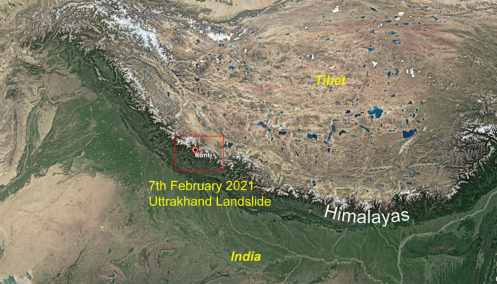
Rising global temperature and melting of glaciers in the Himalaya are changing the Himalayan cryospheric dynamics and causing a dramatic increase in the frequency and magnitude of the natural and anthropogenic hazards. One such example was the 7th February 2021 Uttarakhand landslide-induced floods, which killed almost 200 people and washed away two hydropower dams, amidst when India was dealing with the current global Covid-19 situation.
On the morning of the 7th February 2021, a catastrophic flooding event took place in Uttarakhand, India, which claimed the lives of at least 200 people [1]. You can read a report of the destruction caused on Al Jazeera news. The event is believed to have originated on the Ronti Peak, along the western portion of the Nanda Devi Glacier at an elevation of 6063 m, and flooded the Dhauliganga/Rishiganga Rivers draining the Garhwal Himalaya [1, 2]. This event brought back vivid memories of the devastating 2013 Kedarnath-Uttarakhand flooding, which caused more than 6000 casualties and around 1’000’000 evacuations [3].
Since its advent, the February 2021 flooding event has grappled the Earth science community and the journalists on its triggering mechanism because of its remote location (6063 m elevation) in the Garhwal Himalaya. Two hypotheses were put forward to explain the cause of this catastrophe: Glacial Lake Outburst Floods (GLOF)? Or a landslide?
The initial reports suggested a Glacial Lake Outburst Flood (GLOF), a flash flood caused by the sudden discharge of the moraine-dammed lakes [3]. The GLOF, in general, is triggered by the ice or debris fall, either caused by the intense seismic shaking or by the overtopping of the waves breaching the holding capacity of the dammed lake [4].
Photo 1: 3D rendering GIF showing before and after source location of the 7th February landslide event.(Credit: With permission from CS Waston).
However, just within two days from the event, the researchers, Dr D.H Shugar at the waterSHED Lab and Dr C.S Watson at the University of Leeds, found a landslide to be the potential cause of the 7th February flooding (Photo 1, 2). The analysis of images acquired by the high-resolution Pléiades satellite (French CNES satellite with a resolution of ~50 cm) further corroborated the landslide hypothesis (Photo 2). The satellite data revealed a ~550 m long detachment area (dark scar) on the northern face of the Ronti Peak (Photo 2) where a massive block of ice mixed with rock debris detached, falling vertically ~2.9 km before hitting the valley floor [1, 2]. The aerial survey by the Indo Tibetan Border Police (ITBP) further confirmed the cause and revealed the probable site of the landslide.
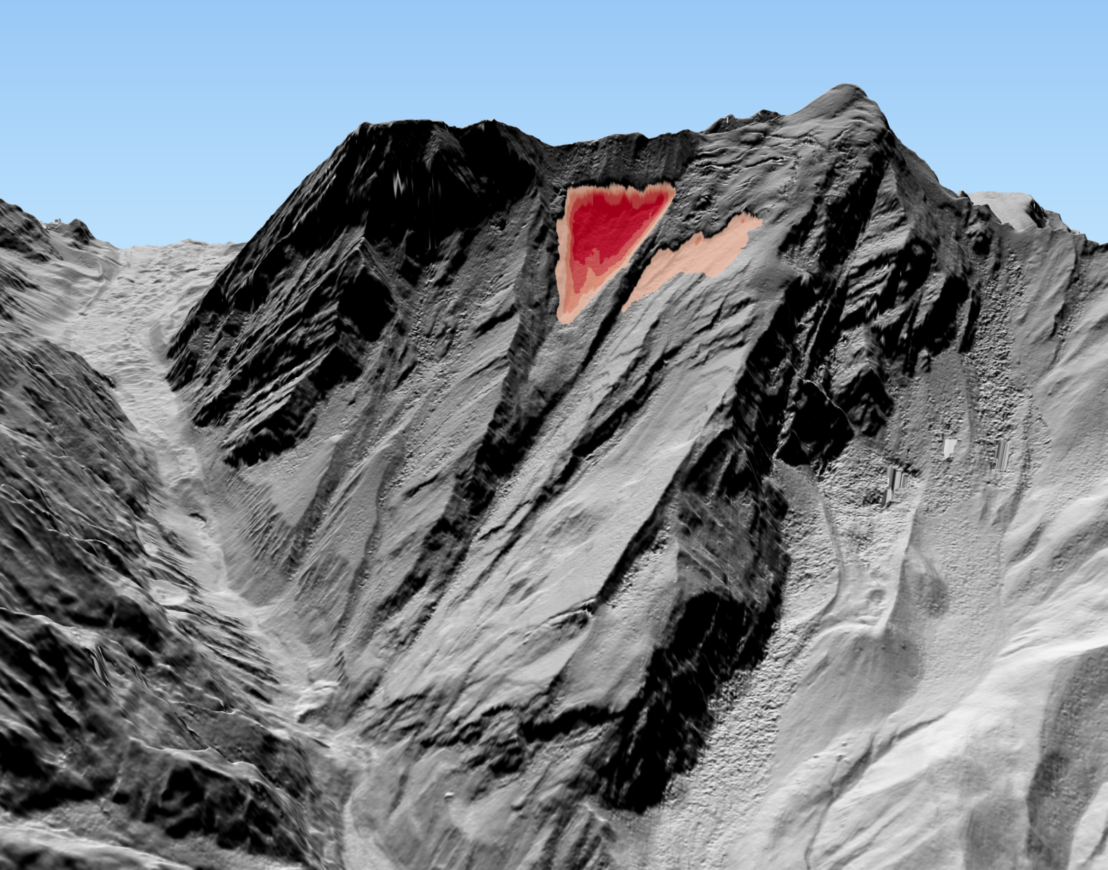
Photo 2: Pléiades satellite DEM showing the source location of the landslide and development of the scar on the face of the glacier due to the landslide (Credit: With permission from Simon Gascoin, https://twitter.com/sgascoin, Source: Pléiades © CNES 2021 Distribution Airbus DS and Maxar/DigitalGlobe WorldView-1 and WorldView-2).
The Himalaya is the highest mountain chain in the world and the third-largest reserve of glaciers after the Polar regions [5]. These water reserves feed millions of people living in the Himalayan valleys and the Indo-Gangetic plain through irrigation, hydropower generation, and domestic use. Hydropower generation has gained momentum in the last few decades. Around 300 dams are either planned or in construction, making the Himalaya a region with the highest dam density in the world [6]. Catching with the pace of human intervention along the pristine Himalaya, floods, landslides, and GLOFs’ frequency has also increased, raising concerns for the safety of the dams and people living downstream. The Uttarakhand 2021 landslide-induced flooding event was an eye-opener. It washed away two hydropower dams under construction downstream of the Dhauliganga/Rishiganga River, trapping 176 people working there at the time.
India aims to achieve net-zero greenhouse gas emissions by 2050. To reach the goal, the Indian government relies heavily on developing renewable energy resources and indirectly on hydropower generation, for which dam construction is an integral part. At present, in Uttarakhand, there are at least 33 hydropower projects [7] underway, along with a wider network of new highway construction leading to the heart of the Himalaya. These constant interferences within the untouched and fragile environment of the Himalaya are adding up to the disasters. Researchers are warning about the increased frequency of such disasters due to the rising global temperature (0.15°C- 0.6° per decade) and decreasing ice cover in the Himalaya [8, 9]. In an IPCC 2019 special report, attention was given to the disturbances that the changing climate has on our planet’s cryosphere. As mentioned, “the glacier, snow, and permafrost decline have altered the frequency, magnitude, and location of the cryospheric related natural hazards, affecting the people. Glacial retreat has made the mountain slopes unstable and the number of glacial lakes and snow avalanches have increased in some regions” [10].
Moreover, to make the situation worse, Uttarakhand has experienced two earthquakes in the past, the 1991 Uttarkashi earthquake (Mw 6.8) and the 1999 Chamoli earthquake (Mw 6.6) and lies in the central seismic gap where the possibility of future Mw 8 earthquakes exists [11]. Numerous instances in the Himalaya have shown that seismic activity is usually accompanied by landslides and floods, which add up to those caused by climate change. It is, therefore, crucial for the Indian government to formulate a strategy to curb the risk posed by these imminent hazardous events.
Towards finding a solution to this precarious problem, first and foremost, a proper seismic hazard assessment, together with constant mapping and monitoring of the glaciers, are required in the Himalaya. Further, acknowledging that Himalayan glaciers are melting is of utmost importance. Second, discussions on the future of hydropower generation and the distribution of the energy share to other renewable resources such as wind and solar energy are the need of the hour. Therefore, in my opinion, demonizing the dams won’t lead us far. Instead, it is important to strike a balance to limit carbon emissions, global warming, and dependency upon the dams for the safety of the millions of people living in the foreland of the Himalaya.
References
[1] Shugar, D.H et al., (2021). A massive rock and ice avalanche caused the 2021 disaster at Chamoli, India Himalaya, Science 2021.
[2] Martha, T.R., Roy, P., Jain, N. et al., (2021). Rock avalanche induced flash flood on 07 February 2021 in Uttarakhand, India—a photogeological reconstruction of the event. Landslides.
[3] Allen, S.K., Linsbauer, A., Randhawa, S.S. et al. (2016). Glacial Lake outburst flood risk in Himachal Pradesh, India: an integrative and anticipatory approach considering current and future threats (2016). Nat Hazards 84, 1741–1763.
[4] Veh, G., Korup, O., von Specht, S. et al. (2019). Unchanged frequency of moraine-dammed glacial lake outburst floods in the Himalaya (2019). Nat. Clim. Chang. 9, 379–383.
[5] Rasul, G., Dahe, Q., & Chaudhry, Q,Z. (2008). Global Warming and Melting Glaciers Along Southern Slopes of Himalaya-Karakoram-Hindukush Ranges. Pakistan Journal of Meteorology, Vol 5, Issue 9, 2008.
[6] South Asia Network on Dams, River & People, Dec (2012)
[7] UJVN, A Government of Uttrakhand Enterprise
[8] IPCC, 2001a: Climate Change (2001). Synthesis Report. Contribution of Working Groups I, II, and III to the Third Assessment Report of the Intergovernmental Panel on Climate Change [Watson, R.T. and the Core Writing Team (eds.)]. Cambridge University Press, Cambridge, 398 pp.
[9] Nie, Y., Pritchard, H.D., Liu, Q. et al.(2021). Glacial change and hydrological implications in the Himalaya and Karakoram. Nat Rev Earth Environ 2, 91–106 (2021).
[10] Hock, R., G. Rasul, C. Adler, B. Cáceres, S. Gruber, Y. Hirabayashi, M. Jackson, A. Kääb, S. Kang, S. Kutuzov, A. Milner, U. Molau, S. Morin, B. Orlove, and H. Steltzer, (2019). High Mountain Areas. In: IPCC Special Report on the Ocean and Cryosphere in a Changing Climate [H.-O. Pörtner, D.C. Roberts, V. Masson-Delmotte, P. Zhai, M. Tignor, E. Poloczanska, K. Mintenbeck, A. Alegría, M. Nicolai, A. Okem, J. Petzold, B. Rama, N.M. Weyer (eds.)].
[11] Kristin D. Morell, Mike Sandiford, C.P. Rajendran, Kusala Rajendran, Abaz Alimanovic, David Fink, Jaishri Sanwal (2015). Geomorphology reveals active décollement geometry in the central Himalayan seismic gap. Lithosphere 7 (3): 247–256.
Post edited by Asimina Voskaki, Giulia Roder, Valeria Cigala
RITESH ARYA
Hi Shreya Please correct
it should be renewable in this sentence
distribution of the energy share to other non-renewable resources such as wind and solar energy are the need of the hour
Vale Cigala
Thank you for spotting the mistake! We have corrected it.