The Italian Catalogue of Earthquake-Induced Ground Failures (CEDIT) is a database available online since January 2013 that stores data about ground failures induced by strong earthquakes, which occurred on the Italian territory since 1000 AD up to now. CEDIT is freely available on a web-GIS portal (currently the access is granted using Firefox as a web browser, the upgrade to other browsers is in process, Ed.) of the CERI Research Centre. His current curator is Salvatore Martino, Associate Professor in Engineering-Geology at Sapienza University of Rome (Italy).
 Hi Salvatore, would you briefly tell us the story of CEDIT and how you have conceived it?
The first release of CEDIT (Delfino and Romeo, 1997) reported ground failures induced by earthquakes over about one millennium, up to 1984. Previously, there was only a thematic map, published by Zecchi (1987) on which the earthquake-induced effects on the Italian territory, based on historical documentary sources, were reported.
The idea of implementing the CEDIT catalogue, and renewing it for realising an online version, was born from a discussion with my colleague Roberto Romeo in the early 2000s and a vital impulse given by the then CERI Director, Alberto Prestininzi. The initial idea was to check the accuracy and update the previous version and to conceive a system of geolocalisation of the inventoried effects that was easily accessible by technicians and researchers.
Numerous issues were already addressed at the time including: 1) the precision of geolocalisation and the need to differentiate it, based on the accuracy of the historical source; 2) the association of each effect with a specific official location’s code provided by the Italian National Institute of Statistics (ISTAT); and 3) the association of the effects not only with the macroseismic properties of the earthquake that had induced it but also to the seismotectonic sources (trying, where possible, to associate it with a source code attributed by the official database of the Italian Geophysical and Volcanological National Institute – INGV).
After a first substantial update of the catalogue, published in Fortunato et al. (2012) following the 20 May 2012 Emilia earthquake, the online edition was created, using a WebGIS graphical interface on the CERI website. Further updates followed the 2016-2017 earthquakes in Central Apennines, as reported in Caprari et al. (2018), up to the latest update related to the ground effects induced by the earthquake occurred on 16 August 2018 in Molise.
How did you collect data about historical earthquakes?
The data related to the historical earthquakes have been taken from the official catalogues of the INGV database (CFTI5 and CPTI15). Still they were integrated with several other sources from the technical and scientific literature. The final result is an accurate synthesis of documentary information which associates the specific classification of the earthquake-induced ground effects (e.g. types of landslide, types of liquefaction) and their geolocalisation based on the source of the data (i.e. chronicle, document, literature) with macroseismic and seismotectonic parameters.
How do you collect data about recent earthquakes?
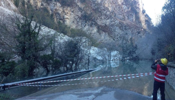
CEDIT is currently the most updated catalogue of earthquake-induced effects in Italy. This has been possible thanks to fieldwork campaigns carried out by a team of CERI researchers who are used to operate after each seismic sequence to directly catalogue the earthquake-induced ground effects. To this aim, the highest precision allowed by satellite cover is adopted for the geolocalisation, and the descriptive criteria requested by the CEDIT catalogue are directly followed to collect the inventoried data in the post-earthquake field surveying. During the last seismic sequence of the Central Apennines, the inventorying activity required an intense and continuous intervention on the territory by several teams, including >3 CERI researchers, from 25 August 2016, intensifying field surveys and measurements immediately after the mainshocks, and until January 2017.
What kind of data/info can users obtain from CEDIT?
The CEDIT geo-database includes five different tables (fig. 1): 1) the EARTHQUAKE table contains information related to the earthquakes themself; 2) the EFFECT table contains information related to the ground effects induced by the earthquake, collected from literature and other official catalogues as well as specifically inventoried by the CERI research team; 3) the PHRASE table contains information related to the sources of the historical earthquakes (e.g. sentences reported in historical documents); 4) the BIBLIOGRAPHY table contains information related to the literature sources; 5) the SURVEY table contains information related to the field surveying activities carried out by the CERI research team.
Thanks to WebGIS, it is possible to query the online catalogue by extracting and downloading information contained in the tables mentioned above, for a specific earthquake or a particular area (fig. 1).
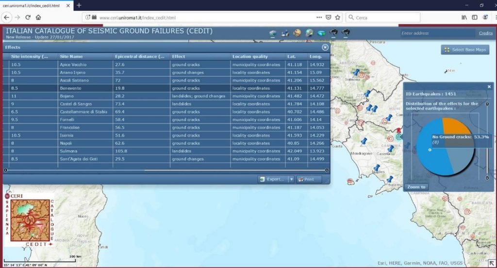
Figure 1. Screenshot of a consultation query from the on-line CEDIT catalogue. The blue pointers on the map show the earthquake-induced ground effects, the pie diagram reports the statistics for type of effects, the table allows the downloading of the inventoried records.
How do you expect users may use the CEDIT catalogue?
The data collected in the CEDIT database can be used to statistically investigate the earthquake-induced effects documented in a specific study area. After that, it is possible to train susceptibility models and provide data for seismic microzonation studies (Martino et al., 2019b) available in the official repositories of the Italian National Civil Protection as well as on the technical web-sites of the Italian Regions.
Moreover, the CEDIT data has been considered so far for the analysis of earthquake-induced scenarios as well as to perform statistical studies (Aversa et al., 2016; Bonini et al., 2019; Forte et al., 2019). In Martino et al. (2014), it was observed that a threshold earthquake magnitude of approximately 4.5 is likely to be the minimum value required to trigger ground effects; while in Caprari et al. (2018), they discussed that landslides represent more than 50% of the total inventoried earthquake-induced effects in Italy (fig. 2).
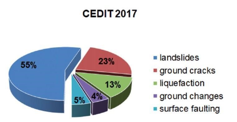
Figure 2. Pie-diagram showing the statistics from CEDIT of the inventoried earthquake-induced ground effects in Italy (from Caprari et al., 2018).
Moreover, as it results from the distribution of exceedance probability (the probability with which a process or event exceeds some critical values, Ed.) vs. earthquake site intensity (MCS, which categorize the intensity or severity of ground shaking at a given location, different from earthquake magnitude, Ed.) for different types of ground effects (Martino et al. 2014), landslides and ground cracks are expected to be induced with 50% of probability for MCS of VI-VII while liquefaction, ground changes and surface faulting, are expected to occur with 50% of probability for MCS>VII (fig. 3).
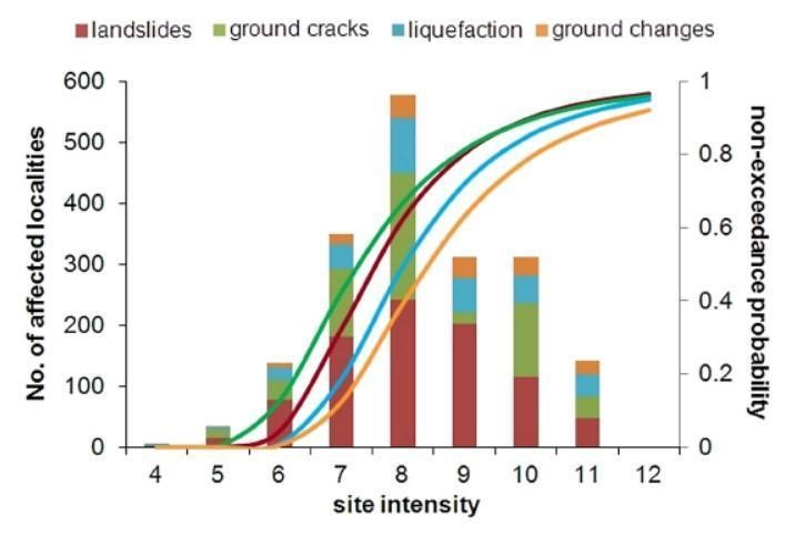
Figure 3. Distribution of different earthquake-induced ground effects vs. macroseismic site intensity as derived from the CEDIT database (from Martino et al., 2014): the histogram shows the number of inventoried effects for each macroseismic intensity class (left axis); the curves express the probability of exceedance vs. macroseismic site intensity for each typology of effects (right axis).
One of the most relevant results obtained from the analysis of the CEDIT database, since its update in 2012, is an upper-bound curve of maximum distance from epicentre vs. magnitude, expected for disrupted landslides (Keefer, 1984) specifically valid for the Italian territory (Martino et al., 2014). This curve, compared in Martino et al. (2019) with the earthquake-induced ground effects related to the 2016-2017 seismic sequence, revealed its reliability. The reliability of this curve provides expected maximum distances of occurrence for earthquake-induced disrupted landslides in the assessment of hazardous scenarios (fig. 4).
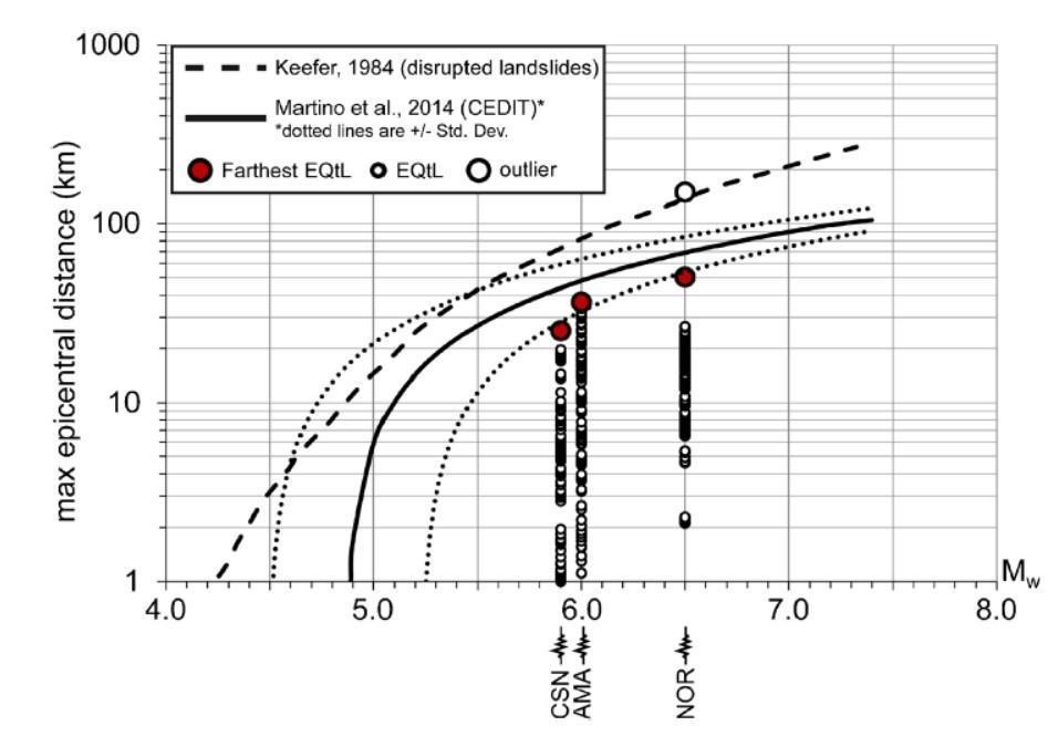
Figure 4. The upper-bound curve of maximum expected distance vs. magnitude for disrupted earthquake-induced landslide in Italy, derived from the CEDIT database (Martino et al., 2014) and compared with the one by Keefer (1984). The distribution of effects inventoried after the last 2016-2017 seismic sequence in Central Apennines is also reported (from Martino et al., 2019).
What are your future plans and what do you expect for CEDIT in the future?
An upgrade of the online consultation interface of the CEDIT catalogue is planned to make it more performable and user-friendly. Besides, the CEDIT data will be partly (for the most recent earthquakes) included into the USGS Open Repository of Earthquake-Triggered Ground-Failure Inventories (https: //www.sciencebase.gov/catalog/item/583f4114e4b04fc80e3c4a1a).
Furthermore, CEDIT data are already used to train GIS-based procedures for the susceptibility assessment of landslide seismic induction, including PARSIFAL (Probabilistic Approach to pRovide Scenarios of earthquake ‐ Induced slope FAiLures – Martino et al., 2019b) as well as multivariate analysis approaches, such as those already applied for microzonation studies in Central Apennines municipalities after the 2016-2017 seismic sequence (Martino et al., 2019a) or based on the use of neural networks.
For more info on CEDIT write at: ceri-cedit@uniroma1.it, salvatore.martino@uniroma1.it
References
Aversa et al. (2016). Engineering Reconnaissance following the 2016 M 6.0 Central Italy Earthquake: Ver 1. DOI:10.18118/G65K5W
Bonini et al (2019). Testing Different Tectonic Models for the Source of the Mw 6.5, 30 October 2016, Norcia Earthquake (Central Italy): A Youthful Normal Fault, or Negative Inversion of an Old Thrust? Tectonics. DOI 10.1029/2018TC005185
Caprari P., Della Seta M., Martino S., Fantini A., Fiorucci M., Priore T. (2018). Upgrade of the CEDIT database of earthquake-induced ground effects in Italy. Italian Journal of Engineering Geology and Environment, 2 (2018): 23-39. DOI: 10.4408/IJEGE.2018-02.O-02
Delfino L. and Romeo R.W. (1997). C.E.D.I.T., Catalogo nazionale degli Effetti Deformativi del suolo Indotti da forti Terremoti. Rapporto Tecnico SSN/RT/97/04.
Forte G., Fabbrocino S., Silvestri F., Santucci de Magistris F. (2019). Assessment of seismic slope stability at different scales in Molise Region (Southern Italy). Earthquake Geotechnical Engineering for Protection and Development of Environment and Constructions – Silvestri & Moraci (Eds) © 2019 Associazione Geotecnica Italiana, Rome, Italy, ISBN 978-0-367-14328-2.
Fortunato C., Martino S., Prestininzi A., and Romeo R. W. (2012). New release of the Italian catalogue of earthquake-induced ground failures (CEDIT). Italian J. Eng. Geol. Environ., 2: 63–74. DOI: 10.4408/IJEGE.2012-02.O-05
Keefer D. K. (1984). Landslides caused by earthquakes. Geol. Soc. Am. Bull., 95, 406–421. https://doi.org/10.1130/0016-7606(1984)95<406:LCBE>2.0.CO;2
Martino S., Battaglia· S., · D’Alessandro F., · Della Seta M., · Esposito C., Martini G., Pallone· F., · Troiani F. (2019b). Earthquake-induced landslide scenarios for seismic microzonation: application to the Accumoli area (Rieti, Italy). Bulletin of Earthquake Engineering, https://doi.org/10.1007/s10518-019-00589-1
Martino S., Bozzano F., Caporossi P., D’Angiò D., Della Seta M., Esposito C., Fantini A., Fiorucci M., Giannini L.M., Iannucci R., Marmoni G.M., Mazzanti P., Missori C., Moretto S.,Piacentini D., Rivellino S., Romeo R.W., Sarandrea P., Schilirò L., Troiani F., Varone C. (2019a). Impact of landslides on transportation routes during the 2016–2017 Central Italy seismic sequence. Landslides. DOI 10.1007/s10346-019-01162-2
Martino S., Prestininzi A., Romeo R.W. (2014). Earthquake-induced ground failures in Italy from a reviewed database. Nat. Hazards Earth Syst. Sci., 14: 799-814. doi:10.5194/nhess-14-799-2014
Zecchi R. (1987). Carta della distribuzione degli effetti geomorfologici indotti dai terremoti che hanno interessato l’Italia dall’anno 0 al 1986. Mem.Soc.Geol.It, 37: 823-826.