As NhET, we have the pleasure to have Mauro Agate as our guest and interviewee today. We discuss about submarine canyons and related geo-hazards. Further details will be available at: http://www.sciencedirect.com/science/article/pii/S0967064513002488 for a scientific-oriented audience;
or https://www.youtube.com/channel/UCwWErQNoZYpJhhkxPa82x5g for a broader audience.
 Dr. Mauro Agate is a marine geologist and a stratigrapher working at Earth and Marine Sciences Department of Palermo University (Italy) where he teaches Marine Geology and Sedimentology. He has taken part in more than 25 oceanographic cruises in the central Mediterranean Sea. He focuses on: i) effects of sea level change on sedimentary dynamics of shelf-to-slope systems; ii) geomorphological and geological mapping of seafloor; iii) origin and evolution of submarine canyon systems; iv) tectono-sedimentary evolution of continental margins.
He has contributed to several research projects: VECTOR (Vulnerability of Italian marine coasts and ecosystems to climatic change); CARG (Geological mapping); MAGIC (Marine geohazards along the Italian coasts); EMODNet (European marine observation and data network).
Interview:
1) Which is the main topic of the research we are going to discuss today?
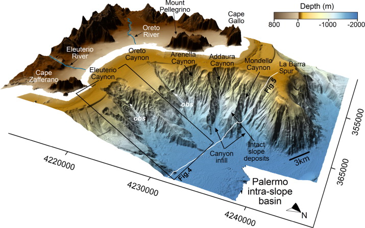
I will focus on submarine canyons as they are one of the most widespread morphologies shaping the ocean floor. These erosional features may extend seawards across continental margins for hundreds of kilometres (> 400 km) and occasionally have canyon wall heights of up to 5 km, from canyon floor to canyon rim. Submarine canyons play a key role in the framework of oceanographic and sedimentary processes, acting as conduits for the transfer of sediment from mainland to the deep sea, and controlling meso-scale oceanographic circulation as well as controlling the functioning of specific benthic habitats.
2) How do submarine canyons originate?
For years, the origins of submarine canyons have been the subject of debate among investigators, and various ideas have been proposed. As already suggested by Shepard in a famous paper dated 1981, multiple causes may contribute to the origin of a canyon. Canyons are fundamentally erosive features, yet some of them show a very complex evolution characterized by alternating erosive and depositional stages.
It is important to separate two main types of submarine canyons, because the origin, evolution and quality of related ecosystems are very different: a) shelf-indenting, sediment fed canyons and b) slope-confined, retrograding canyons. Marine geological and geophysical research documented as slope-confined canyons can retrogressively develop up to the shelf edge, and recent studies, also based on numerical modelling, suggested that these canyons formerly originated from downslope-eroding sediment flows. Some shelf-indenting canyons may cross the continental shelf in its entirety and link to current fluvial networks. Submarine canyons display many similarities with exposed river systems, but also relevant differences.
3) Why it is important to understand submarine canyon origins and evolution?
The unravelling of submarine canyon dynamics has been driven by the need to plan safe routes along which to place cables and pipelines across the seafloor. Often, at the down-slope end of the canyon, sedimentary submarine fans may occur. These represent modern analogues for ancient deposits of economic significance (hydrocarbon source-rock and reservoir). Moreover, oceanographic implication of canyon activity, by mixing of shallow water with upwelling of deep water can also enhance local primary productivity: consequently, commercially relevant fisheries are commonly located at the heads of submarine canyons.
Further on, among deep ocean geomorphic features, the heads of some shelf-incising submarine canyons have been identified as supporting ecosystems (e.g. cold-water coral communities). These are especially vulnerable to human activities, mostly as consequence of water acidification caused by anthropogenic climate change and bottom trawl fisheries. In particular, the trawling practise could have an enormous impact on canyon dynamics by altering deep-sea sediment transport pathways and ecosystems.
Ultimately, a more complete understanding of the canyon activity may help us in preventing some natural and anthropogenic hazards.
4) What types of hazards are related to the underwater canyons?
Two main types of hazards are associated with the presence of submarine canyons and their related processes: landslides and dispersion of pollutants.
Submarine slides can be generated by the failure of canyon wall and head-scarp. Usually mass wasting phenomena occurring inside the canyon are not very large in size. However, they can be dangerous for cables and pipelines. Moreover, in some canyons, the headward erosion driven by downslope-cutting sediment flows and the following landward shift of the canyon head may come to threaten harbor facilities or other anthropic settlements located along the coast. In 1979 a landslide in the head of the Var Canyon in the Gulf of Lions, involved a volume of about 9 million m3 of material and caused a tsunami wave of about three meters that damaged part of the work to extend the airport of Nice and killed 10 people. Similarly, in southern Italy, along the Tyrrhenian coast of Calabria, in 1977 a submarine landslide in the head of Gioia Tauro canyon mobilized about 5 million m3 of material generating a tsunami and a turbidity current which caused serious damage to the port and the break of submarine cables. Even away from settled regions, the retreat of the canyon heads can cause extensive damage such as the sudden disappearance of entire stretches of sandy coastline.
If the canyon walls and head were stable, however, the same morphology of a submarine canyon could represent a threat in case of earthquakes or tsunamigenic landslides because the bathymetric pattern of the canyon can amplify (or simply not mitigate) a possible tsunami wave. Such different effects of sea floor bathymetry on tsunami characteristics have been documented. Examples are the tsunami in 1998 affecting the island of Papa New Guinea and the Indian Ocean tsunami on 26 December 2004 affecting on the Bangladesh coast.
As concerns dispersion of pollutants, at present not many studies have been carried out. However, there is growing evidence that sediment transport along the canyon can contribute to contamination of pelagic sediments by industrial waste and chemical pollutants coming from coastal areas and subsequent accumulation in deep-sea fauna.
5) What are the most advanced methodologies for the investigation of submarine canyons and what further discoveries do you expect from the upcoming research?
During the past two decades, the wide-spread use of the Multibeam echo-sounder devices in underwater geological surveys have provided wonderful images of the seabed. This allowed for quantitative morphometric analysis of submerged geomorphological features, among which the submarine canyons. We currently know very well the shape, morphologies and sizes of these fascinating features. Probably further advances in understanding the mechanisms of the canyon function can only come from multidisciplinary research that integrates geophysical, sedimentological, oceanographic and biological analyses. A multidisciplinary approach, such as the one followed in the ISLAND Project (ExplorIng SiciLian CAnyoN Dynamics) recently promoted by the European program EUROFLEETS (www.eurofleets.eu), is now essential not only to better understand the sedimentary dynamics and evolutionary mode of submarine canyons, but also to assess the impact of canyon activity in generating natural hazards and controlling benthic ecosystems stability.