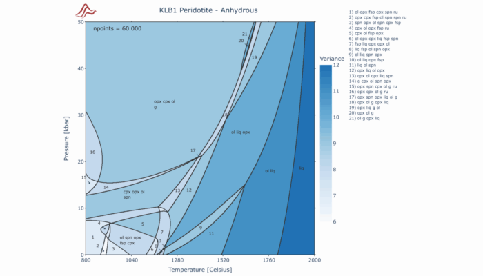
Geodynamic models and landscape evolution models are becoming important tools to quantify the formation and development of paleogeographic features, contributing to our understanding of the patterns of biodiversity evolution. Earth, a dynamic system The Earth’s surface works as a dynamic system and is continuously sculpted through the geological timescale by weathering, wind, rivers, and many othe ...[Read More]
T for temperature in seismic [T]omography and more
Seismic tomography, a powerful geophysical technique, is like the Sherlock Holmes of the Earth’s interior. It helps us uncover crucial information about the lithosphere and mantle, including temperature and density distributions. Understanding these physical properties is vital for a wide range of geological applications, from identifying regions of strain localization to assessing geotherma ...[Read More]
On the usefulness of geodynamic numerical models
Within the vast realm of geoscience, the intricate mechanisms governing Earth’s internal processes continually pose challenges for researchers attempting to unveil its mysteries. This blog post acknowledges the inherent limitations of geological and geophysical data while highlighting the important role that geodynamic modeling plays in bridging these datasets. The motivations for this discu ...[Read More]
How does slab tearing evolve?
Slab tearing refers to the gradual propagation of the break-off of a subducting plate. As observed in numerous modern and ancient convergent tectonic settings, the growth of the tear “window” in the downgoing plate has strongly influenced various geologic and geodynamic processes, such as depocenter migration of foreland basins, uplift rates in mountain ranges, earthquakes, volcanism, and flow pat ...[Read More]