The human lifespan is too short compared to the geological time. To comprehend long-term phenomena, numerical modeling emerges as an imperative approach. But, there are several ways for visualizing the output of these models. Among these, animations stand out as a powerful tool, allowing us to watch the dynamic evolution of our planet over geological epochs like a movie.

PhD student in Geophysics at University of São Paulo, interested in numerical modelling of tectonic processes from rifting to continental collision. His PhD research goal is to understand how tectonic processes changed over geological time.
Our lives are too short compared to the geological time scale
When we have too many engaging tasks to do during the day, it feels like time passes faster than we would like. On the other hand, when we anticipate a package or the food to cook in the microwave, it feels like time is crawling slowly. From the Earth’s perspective, both events are instantaneous as most geological processes happen as if they were in slow motion for us, with durations longer than thousands of human lifes. For instance, the continents of South America and Africa move apart at a speed of approximately 3 centimeters per year, which is comparable to the average speed of growth of our nails.
Geologists have great tools to study how the Earth evolves, but are limited to the first 10 km of our planet. Using mechanisms to observe and quantify the properties of the rocks, they study how the landscape has evolved over millions (and even billions) of years. This is not a trivial task, as preserved ancient rocks are rare due to the dynamics of our planet, which constantly erodes and destroys rocks. For this type of data, we are trapped in a relatively minuscule lifespan trying to understand and picture how the world was in the past and how the landscape evolved or will evolve.
From a different perspective, we have the geophysicists. Just as a physician uses x-rays, tomography, or ultrasound to image the inside of our bodies, geophysicists use analogous techniques to image the world beneath us and study its properties. Such studies can focus on how seismic waves travel through the planet, how the resistivity of rocks changes in subsurface, or how the acceleration of gravity changes from one place to another. Despite being able to survey the Earth at great depths, this imaging of the Earth’s interior is restricted to the present time. As surface evolution is also affected by the dynamics of the planet, the role of a geodynamics researcher is to tie these two types of data (Gerya, 2014).
When I was a kid, I liked to think I could use a time machine to go back to the past and explore how the mountains, deserts and oceans were formed, or see what life looked like beyond the fossil record. Since we cannot go back in time to visualize those things, how can we visualize, for example, the evolution of the landscape in a nearly continuous way? The answer for this question can be animating data generated by simulations made in computers, and it is the closest we can get to a “time machine”.
Using the tools available
We are constrained by our tools trying to fill the gap between geological and geophysical data. Using both physics and computational sciences, we can simulate geological phenomena by numerically solving equations using a computer. This kind of approach is also known as numerical modeling. Simulations are already used in several areas of our lives, for example in weather forecast and engineering problems.
Using our personal computers or supercomputers with thousands of computing cores available, numerical modeling allowed us to spend a few hours simulating geological processes that can take up to billions of years.
However, some aspects of nature are challenging to simulate in a computer. This is due to the time required to solve the system of equations that describes a certain phenomenon, for example, the fluid dynamic constitutive equations used to model the evolution of both the Earth’s core and mantle. The continuous scalability, speed and efficiency of algorithms throughout the years allowed us to create faster softwares to solve these equations and process a big amount of data in a reasonable time. Nowadays we can simulate scenarios of continental breakup, continental collision, and landscape evolution.
Visualization is the key
The lithosphere is the outermost brittle shell of our planet. It is created from the magma that comes out of the volcanoes at regions where plates move apart from each other (diverge), such as the Mid-Atlantic Ridge. In a general way, lithosphere is destroyed at regions where plates converge, where the denser lithosphere sinks (subducts) into the mantle while the less dense plate is folded and uplifted forming mountains, such as the Andes in South America and Himalayas. At the same time, the rocks are slowly destroyed (eroded) by the effects of wind, rain and ice.
The theory that the Earth is composed of interacting plates is called Plate Tectonics, and there is not a consensus among scientists about when it started. Korenaga (2013) compiled the works of several authors that suggested the onset of Plate Tectonics started somewhere between 4200 to 850 millions of years ago (Ma). Numerical modelers took this as an opportunity to use their “time machines” and conducted different numerical simulations using both the geological and geophysical data, computational methods, and the laws of physics.
The output of a numerical simulation is a set of numbers, which are very hard to interpret in a textual form. So, scientists had to develop ways to process, visualize, and interpret the data in useful ways. One of these ways is to visualize on our screens the geological processes “happening” like a movie.
To illustrate how we can do that and “animate the past”, Figure 1 shows the result of a simulation I made using the code MANDYOC (Sacek et al., 2022). The data was processed with Python scripts using the Matplotlib and Numpy libraries to create frames and generate a gif of the simulated scenario. The simulation represents a continental breakup (from 0 to 30 million years) followed by continental collision (from 30 to 120 million years).
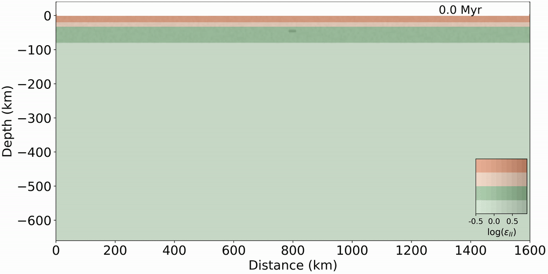
Figure 1: Simulation of a cycle of continental breakup (from 0 to 30 million years) followed by continental collision (from 30 to 120 million years). Layers from top to bottom are: upper crust, lower crust, lithospheric mantle and asthenospheric mantle. Shading areas represent the logarithm of the accumulated strain and help us to identify the deformation in the lithospheric layers.
In Figure 1, it is possible to see how the lithosphere (the upper three layers) is stretched during the extension period resulting in two different blocks (rifted margins). After that, the process is inverted to reproduce the mountain building during a continental collision. Note how the upper layers are folded like a fabric as the compressional process acts over geological time creating a mountain chain.
Thanks to numerical modeling and data processing, we could visualize in less than 10 seconds a process of a hundred million years!
Similarly, Salazar-Mora et al. (2018) did simulations that include continental collision and continental break up (Figure 2). According to their results, inherited structures from the continental collision are reactivated during the continental break up and development of wide margins, which are those where the extension of the crust creates a continental shelf of 100 to 600 km wide. Furthermore, the reactivation of extensional structures are related to the formation of narrow margins which are those with a continental shelf shorter than 100 km wide.
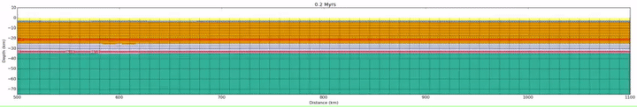
Figure 2: Simulation of continental collision (from 0 to 30 million years) followed by continental breakup (from 30 to 50 million years) forming a wide margin at the right side at the end of simulation. Layers from top to bottom are: sediments, salt, upper crust, lower crust, lithospheric mantle and asthenospheric mantle. Courtesy of Salazar-Mora.
These types of studies are only possible through numerical simulation, and visualization tools play the role of “time machines”, allowing us to see how the Earth changed through geological time.
It’s worth saying that Python scripts based on packages such as Numpy and Matplotlib are not the only way to process and visualize the data. Nowadays we have different softwares, programming languages and packages that we can use to visualize simulation output. Proprietary softwares such as Paraview are also used to visualize 3D data, and programming languages such as Julia, R, and MATLAB are great options to create user interfaces, and process and visualize data. There are groups of developers that are investing time and resources to create initial scenarios and tools for data visualization, such as the groups of LaMEM (Riel et al., 2023) and Underworld (Mansour et al., 2020; Beucher et al., 2019). As a geoscientist, it is a great pleasure to testify those steps towards the understanding of how the Earth was in its past.
References:

[1] Gerya, T. (2014). Precambrian geodynamics: concepts and models. Gondwana Research, 25(2), 442-463,  https://doi.org/10.1016/j.gr.2012.11.008

[2] Korenaga, J. (2013). Initiation and evolution of plate tectonics on earth: theories and observations. Annual review of earth and planetary sciences, 41:117–151, https://doi.org/10.1146/annurev-earth-050212-124208

[3] Mansour, J., Giordani, J., Moresi, L., Beucher, R., Kaluza, O., Velic, M., Farrington, R., Quenette, S., Beall, A., 2020, Underworld2: Python Geodynamics Modelling for Desktop, HPC and Cloud, Journal of Open Source Software, 5(47), 1797, https://doi.org/10.21105/joss.01797

[4] Riel, N., Duarte, J.C., Almeida, J., Kaus, B.J., Rosas, F., Rojas-Agramonte, Y. and Popov, A., 2023. Subduction initiation triggered the Caribbean large igneous province. Nature Communications, 14(1), p.786, https://doi.org/10.1038/s41467-023-36419-x

[5] Sacek, V., Assunção, J., Pesce, A., & Monteiro da Silva, R. (2022). Mandyoc: A finite element code to simulate thermochemical convection in parallel, http://dx.doi.org/10.21105/joss.04070

[6] Salazar‐Mora, C. A., Huismans, R. S., Fossen, H., & Egydio‐Silva, M. (2018). The Wilson cycle and effects of tectonic structural inheritance on rifted passive margin formation. Tectonics, 37(9), 3085-3101, https://doi.org/10.1029/2018TC004962