Every 8 weeks we turn our attention to a Remarkable Region that deserves a spot in the scientific limelight. Following from the first entry which showcased the Eastern Mediterranean, we move further east, and back in time, to the realm of the Tethys. The post is by postdoctoral researcher Sabin Zahirovic of the EarthByte Group and Basin GENESIS Hub, The University of Sydney.
The southern and southeastern region of Eurasia (Fig. 1) represents one of the most tectonically complex areas in the world, with active deformation that appears as flurries of sometimes-deadly earthquakes, as well as the slower processes of mountain building. This region truly represents geophysical extremes, with the world’s tallest mountain ranges (namely, the Himalayas), and the planet’s deepest surface depressions (namely, the Mariana Trench), which collectively demonstrate the ongoing tectonic processes that are shaping, and re-shaping, our planet’s surface. Embedded in every rock, grain, mineral, and fossil in the region is the record of ancient tectonic activity, with a mosaic of exotic terranes sutured onto the continental margin. The Tethys was a vast oceanic domain at the southern margin of Eurasia and parts of its eastern history are now preserved in sutures onshore. The sutures are often peppered with ophiolites (Fig. 2), which are fragments of ancient ocean basins and gateways, the rest of which have been lost to subduction and now reside deep in the mantle. The opening and closure of these ocean basins has also been implicated in fundamental shifts of oceanic circulation and long-term sea level, which highlights the importance of better understanding the tectonic evolution of our planetary surface and deep churning interior.
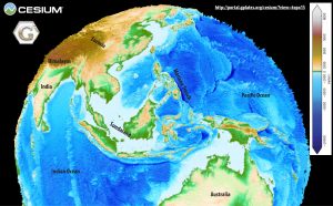
Figure 1. Shuttle Radar Topography Mission data of the eastern Tethyan region displayed in the GPlates web portal, with 50X vertical exaggeration of elevation. (EarthByte Group and Scripps Institution of Oceanography)
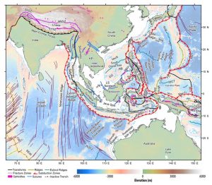
Figure 2. Regional map highlighting the sutures (pink and blue lines) demarcating the terranes of the eastern Tethyan tectonic domain, as well as the ancient ocean basins that have since been consumed by subduction. Figure from Zahirovic et al. (2016b).
The first step to rewinding the tectonic clock requires undoing seafloor spreading in preserved ocean basins. Coincidentally, the geoscience community is celebrating the 50th anniversary of plate tectonics this week, with the understanding of seafloor spreading being a critical component of the plate tectonics paradigm. Through the work of numerous scientists such as Fred Vine, Harry Hess, Drummond Matthews, Dan McKenzie, amongst others, the ideas of seafloor spreading began to take shape. Another visionary who has received less acknowledgement is Marie Tharp, who painstakingly collected and manually plotted sonar measurements from voyages criss-crossing the Atlantic. Marie pieced together the morphology and topology of the mid-oceanic ridge systems (Fig. 3), which were mysterious bathymetric features at the time. When Marie superimposed earthquake epicentres on her maps, and suggested that this could be the missing piece of the continental drift puzzle, her significant insights were initially dismissed. However, Marie’s perseverance and determination laid much of the foundations in our understanding of these bathymetric features representing regions of seafloor spreading, from which a rush of subsequent work established the principles of plate tectonics.
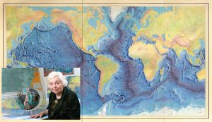
Figure 3. Marie Tharp’s ground-breaking bathymetric map highlighting the elevated mid-oceanic ridge systems, which were later proved to be regions of seafloor spreading (© Marie Tharp 1977). Photograph inset of Marie in 2001 (Columbia University).
Following decades of data collection, including magnetic polarity reversal mapping of the oceans, the age of the oceanic crust and other features of the seafloor fabrics were compiled into global digital community models (e.g., Müller et al., 1997; Matthews et al., 2011). With these two ingredients, one can generate digital models of plate tectonic reconstructions, where the seafloor spreading of the ocean basins can be reversed to reveal the ancient configuration of continents (e.g., the reconstruction of Seton et al., 2012 using open-source community plate reconstruction software, GPlates, (Boyden et al., 2011)). However, due to the conservation of surface area (i.e., the Earth is not expanding), large gaps emerge that represent ancient subducted ocean basins.
As the Atlantic, Southern and Indian oceans opened, it occurred at the expense of the youngest (the Neo-Tethys), which was subducted along the southern margin of Eurasia. This process left a vast chain of arc volcanoes and orogens, stretching from the Alps in Europe to Sundaland in Southeast Asia (Fig. 1). However, only patchy evidence remains of how the continental terranes traversed the Tethyan ocean basins (Fig. 2), with existing methods largely relying on sedimentary affinities, fossil co-occurrences, and paleo-latitudinal estimates from paleomagnetic data (e.g., Metcalfe, 1994; Torsvik and Cocks, 2004). With the advent of modern seismic techniques (e.g., Li et al., 2008), it was possible to “image” the Earth’s mantle using seismic tomography (akin to a medical scan, Animation 1). This led teams of researchers to interpret the mantle structure (Fig. 4), and infer the history of subduction in the absence of preserved data on the surface (e.g., Hafkenscheid et al., 2006; van der Voo et al., 1999). In order to test interpretations of the India-Eurasia convergence that consumed the eastern Neo-Tethyan ocean basin, efforts were then launched to try and reproduce the India-Eurasia mantle structure using numerical models of mantle convection (e.g., Jarvis and Lowman, 2005).
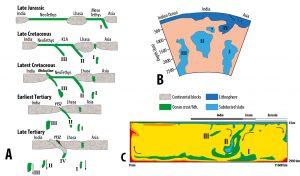
Figure 4. Schematic interpretations of the India-Eurasia subduction history (A) using inferences from seismic tomography (van der Voo et al., 1999) (B), which were then tested using simple numerical experiments of mantle convection (Jarvis and Lowman, 2005) (C). Figures modified from Zahirovic et al. (2016b).
Animation 1. East-west sweep through the eastern Tethyan mantle, highlighting cold subducted slabs (blue) representing ancient Tethyan oceanic lithosphere (tomography model from Li et al., 2008).
With advances in community software platforms to model the evolution of entire plates and their boundaries through time, as well as a near-exponential increase in supercomputing resources, it became easier to model the coupled plate-mantle system in a time-evolving 3D spherical shell (e.g., using tools such as Aspect, CitcomS, and others). These advances enabled us, our colleagues, and the wider geo-community, to track subducting slabs from a complex and evolving global network of plate boundaries, including those associated with the eastern Tethyan tectonic domain. The new models provided an additional insight into the interaction of the deep Earth and surface processes, especially in such a tectonically-complex region like Southeast Asia.
For more than a decade, research has highlighted that Australia’s northern continental margin and the Sundaland continental promontory were low-lying and partially-flooded regions, likely due to the influence of sinking lithospheric plates from the eastern Tethyan slab graveyard (DiCaprio et al., 2009; DiCaprio et al., 2011; Spasojevic and Gurnis, 2012). What the models of mantle flow have revealed is that this effect, known as “dynamic topography”, is a transient signal through space and time, depending on the position of the continents in relation to large-scale mantle upwellings or downwellings. In the case of the eastern Tethys, these mantle downwellings were ephemeral, affecting the relative contribution of global sea level change and regional uplift or subsidence that drove shoreline retreat and advance over the continents. For Southeast Asia, we now think that the whole region was elevated and entirely emergent from about 80 to 40 million years ago, largely due to a hiatus in subduction along southern Eurasia between ~80 and 60 million years ago (Fig. 5). These notions complement traditional ideas of tectonic topography (where the surface experiences uplift or subsidence due to collisional or rifting processes), and allow us to consider the additional role of mantle flow (upwellings and downwellings contributing to several hundred meters in elevation change) over geological time in shaping the surface evolution of our planet.
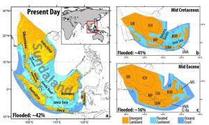
Figure 5. Palaeogeographic reconstructions highlight that Southeast Asian topography was very different in the past, one dominated by a contiguous and emergent landmass about 80 to 40 million years ago, despite higher sea levels than today. Numerical models of the eastern Tethyan region suggests that the absence of subduction between 80 and 60 million years ago led to a “dynamic rebound” of the Sundaland continental promontory. However, the region became flooded again from about 40 million years ago because of a resumption in subduction, which led to regional subsidence, even with falling long-term sea levels. Figure adapted from Zahirovic et al. (2016a).
The plate tectonic reconstructions (Animation 2), along with the mantle flow models, have added significant insights into the evolution of the plate-mantle system. However, one emerging area of study is the exploration of how the shifting tectonic regimes have influenced other Earth systems – whether it be climate, ocean circulation, or biological evolution. In terms of the eastern Tethys, further research will help us uncover the role of tectonics and mantle flow in understanding the deep carbon cycle (at the plate-mantle scale), which has the potential to reveal the flux of carbon between shallow and deep Earth reservoirs, and their influence on deep-time climate (e.g., Jagoutz et al., 2016; Kent and Muttoni, 2013). For example, as the Neo-Tethys ocean basin was consumed, huge amounts of CO2 were emitted through a vast network of convergent plate boundaries that hosted arc volcanoes, leading to warmer greenhouse conditions. However, once India crashed into these subduction systems, the buoyant continental crust jammed and shut down subduction, turning off a major input of CO2 into the atmosphere. In addition, the mountain building processes in the Alpine-Himalayan mountain belt sequestered enormous amounts of CO2 from the atmosphere through chemical weathering of silicate rocks, influencing (and perhaps controlling) long-term cooling of the planet in the last 45 million years. These components collectively highlight the need for more integrative work that unpacks the complexity of regions like the eastern Tethys in order to understand the interaction of physical, chemical, and biological processes that have shaped planetary evolution.
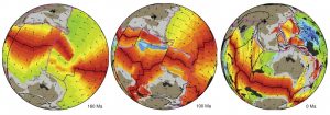
Images from Animation 2 – please click the link below to download the movie file (10MB)
Animation2_SupplementaryAnimation2_Zahirovic_etal_ESR_agegrid
Animation 2 (please click the link above to download and view). The latest plate tectonic reconstructions of the eastern Tethys consider both the evolution of the continents, as well as the oceanic plate that carried it, much like a conveyor belt on the Earth’s surface. The reconstructions are embedded in global models with evolving plate boundaries (GPlates software), and are easier linked to numerical models of mantle convection (Zahirovic et al., 2016b), which provide an additional avenue to test our interpretations of past continental and oceanic arrangements
Note from author: This summary is by no means comprehensive, and represents a personal perspective of plate tectonics and eastern Tethyan geodynamics.
References

Boyden, J., Müller, R., Gurnis, M., Torsvik, T., Clark, J., Turner, M., Ivey-Law, H., Watson, R., and Cannon, J., 2011, Next-generation plate-tectonic reconstructions using GPlates, in Keller, G., and Baru, C., eds., Geoinformatics: Cyberinfrastructure for the Solid Earth Sciences: Cambridge, UK, Cambridge University Press, p. 95-114.

DiCaprio, L., Gurnis, M., and Müller, R. D., 2009, Long-wavelength tilting of the Australian continent since the Late Cretaceous: Earth and Planetary Science Letters, v. 278, no. 3, p. 175-185.

DiCaprio, L., Gurnis, M., Müller, R. D., and Tan, E., 2011, Mantle dynamics of continentwide Cenozoic subsidence and tilting of Australia: Lithosphere, v. 3, no. 5, p. 311-316.

Gurnis, M., Turner, M., Zahirovic, S., DiCaprio, L., Spasojevic, S., Müller, R., Boyden, J., Seton, M., Manea, V., and Bower, D., 2012, Plate Tectonic Reconstructions with Continuously Closing Plates: Computers & Geosciences, v. 38, no. 1, p. 35-42.

Hafkenscheid, E., Wortel, M., and Spakman, W., 2006, Subduction history of the Tethyan region derived from seismic tomography and tectonic reconstructions: Journal of Geophysical Research-Solid Earth, v. 111, no. B8, p. B08401.

Jagoutz, O., Macdonald, F. A., and Royden, L., 2016, Low-latitude arc–continent collision as a driver for global cooling: Proceedings of the National Academy of Sciences, v. 113, no. 18, p. 4935-4940.

Jarvis, G., and Lowman, J., 2005, Sinking slabs below fossil subduction zones: Physics of The Earth and Planetary Interiors, v. 152, no. 1-2, p. 103-115.

Kent, D. V., and Muttoni, G., 2013, Modulation of Late Cretaceous and Cenozoic climate by variable drawdown of atmospheric pCO 2 from weathering of basaltic provinces on continents drifting through the equatorial humid belt: Climate of the Past, v. 9, no. 2, p. 525-546.

Li, C., van der Hilst, R., Engdahl, E., and Burdick, S., 2008, A new global model for P wave speed variations in Earth's mantle: Geochemistry, Geophysics, Geosystems, v. 9, no. 5, p. 21.

Matthews, K. J., Müller, R. D., Wessel, P., and Whittaker, J. M., 2011, The tectonic fabric of the ocean basins: Journal of Geophysical Research, v. 116, no. B12, p. B12109.

Metcalfe, I., 1994, Gondwanaland origin, dispersion, and accretion of East and Southeast Asian continental terranes: Journal of South American Earth Sciences, v. 7, no. 3, p. 333-347.

Müller, R., Roest, W., Royer, J., Gahagan, L., and Sclater, J., 1997, Digital isochrons of the worldís ocean floor: JGR, v. 102, no. B2, p. 3211-3214.

Seton, M., Müller, R., Zahirovic, S., Gaina, C., Torsvik, T., Shephard, G., Talsma, A., Gurnis, M., Turner, M., Maus, S., and Chandler, M., 2012, Global continental and ocean basin reconstructions since 200 Ma: Earth-Science Reviews, v. 113, no. 3-4, p. 212-270.

Spasojevic, S., and Gurnis, M., 2012, Sea level and vertical motion of continents from dynamic earth models since the Late Cretaceous: AAPG bulletin, v. 96, no. 11, p. 2037-2064.

Torsvik, T., and Cocks, L., 2004, Earth geography from 400 to 250 Ma: a palaeomagnetic, faunal and facies review: Journal of the Geological Society, v. 161, no. 4, p. 555-572.

van der Voo, R., Spakman, W., and Bijwaard, H., 1999, Tethyan subducted slabs under India: Earth and Planetary Science Letters, v. 171, no. 1, p. 7-20.

Zahirovic, S., Flament, N., Müller, R. D., Seton, M., and Gurnis, M., 2016a, Large fluctuations of shallow seas in low-lying Southeast Asia driven by mantle flow: Geochem. Geophys. Geosys, v. FRONTIERS IN GEOSYSTEMS: Deep Earth - surface interactions, no. 17.

Zahirovic, S., Matthews, K. J., Flament, N., Müller, R. D., Hill, K. C., Seton, M., and Gurnis, M., 2016b, Tectonic evolution and deep mantle structure of the eastern Tethys since the latest Jurassic: Earth Science Reviews, v. 162, p. 293-337.

