The Division Outstanding Early Career Scientist Awards highlight exceptional scientific contributions made by an Early Career Scientist in the fields of Earth Sciences associated with each division. This year, the prestigious recognition for the Geodynamics Division has been awarded to Dr. Sia Gelichkhan, from the Australian National University. Today we have the pleasure of interviewing him on his research, achievements, and perspectives on the challenges and innovations shaping the future of Geodynamics.
Siavash (Sia) Ghelichkhan is a geodynamicist at the Research School of Earth Sciences, Australian National University, where he joined as faculty in 2024. Originally from Iran, he studied theoretical physics before moving to Munich, Germany, where he completed both a Masters in Geophysics and a PhD in Geodynamics at LMU Munich and the Technical University of Munich. He moved to Canberra, Australia in 2019. His research focuses on applying numerical and inverse methods to geodynamics, with a particular emphasis on adjoint-based approaches for reconstructing mantle flow in space and time. He is a lead developer of G-ADOPT (g-adopt.org), a computational platform for inverse geodynamics. As an Australian Research Council DECRA Fellow, he is currently working on G-PREM, a three-dimensional dynamic reference Earth model for the Cenozoic, aimed at understanding the mantle’s influence on past sea level. Since 2024, he is also a Fellow of the Institute for Water Futures at ANU, where he is developing inverse models of groundwater systems across Australia and globally. More at sia-g.com.
“Recognition like this is not just about the science; it is an acknowledgment that none of it happens alone.“
How would you describe your research in a nutshell?
My research is about turning Earth science observations into quantitative understanding. Over the past few decades, the volume of data describing Earth’s interior has grown enormously. New seismic tomography models appear every year, theoretical models and laboratory measurements of material properties have become increasingly precise, and our theoretical frameworks have matured alongside them. But data alone is not knowledge. The central question I work on is: how do we systematically assimilate these diverse observations into physically consistent models of how the Earth works?
The methods I develop are rooted in adjoint-based data assimilation: techniques that allow us to optimise the parameters of computationally expensive simulations against observational constraints. What are the rheological properties that best explain what we observe? What is the evolutionary trajectory of the mantle that is most consistent with the available data? These are inherently inverse problems and solving them at the scale and complexity of real Earth systems demands purpose-built computational tools.
These ideas did not begin in a vacuum. The foundations were laid during my PhD at Ludwig-Maximilians-Universität (LMU) in Munich, where I was fortunate to be part of a community that had pioneered the formal use of data assimilation in mantle convection and seismic tomography. That environment, shaped by my PhD supervisor and by colleagues whose early work on adjoint methods in geodynamics opened the field, gave me both the technical grounding and the scientific conviction that this approach could be taken much further. It was later, during my postdoc at the Australian National University (ANU), guided by my postdoctoral supervisor, that these ideas matured into the framework and ambition behind G-ADOPT.
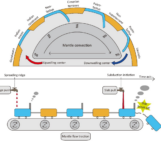
Figure 1 The G-ADOPT logo illustrates the platform’s central ambition: applying data assimilation across Earth’s systems and timescales. From reconstructing the thermal evolution of the mantle over millions of years, to modelling the solid Earth’s response to ice sheet loading and its imprint on sea level, to optimising subsurface flow models against borehole and gravity observations in groundwater systems: the same adjoint-based framework connects them all. (see g-adopt.org).
That need led to G-ADOPT: the Geoscientific ADjoint Optimisation PlaTform. An open-source framework developed collaboratively by our team at ANU (see g-adopt.org and this EGU blog for more). G-ADOPT makes these inversions accessible and reproducible. We have demonstrated its applicability in mantle convection and glacial-isostatic adjustment of Earth’s surface, and we are now extending it to groundwater systems where we are building models of aquifers by assimilating observations from satellite geodesy and borehole data. The underlying ambition is general: to build data-constrained models (what some now call digital twins) of different Earth systems, models that are constrained by what we have actually observed.
Why does this matter? Consider the expected sea-level rise due to climate change. Arguably one of the defining scientific and societal questions of our century. To understand where sea level is going, we look to the geological past: Pliocene shorelines as a proxy of similar green-house concentrations in the atmosphere by the end of this century, glacial cycles, the ongoing rebound of formerly ice-covered land. But every one of those records carries the fingerprint of the solid Earth. A mid-Pliocene sea-level marker does not simply record how much water was in the ocean; it has been moved up or down by dynamic topography driven by mantle flow over millions of years. The present-day rate of relative sea-level change at any coastline reflects the viscoelastic response of the mantle to the last and current deglaciation. These are not small corrections: they can dominate the signal. Disentangling them is not a problem that will be solved once and set aside; it is an ongoing scientific journey, where each answer reveals new layers of complexity. Our methods and tools are designed for exactly that kind of problem: one that demands sustained, rigorous integration of observations, physics, and computation.
What was your reaction to the news that you had been awarded the ECS Division
Award?
Honestly, my first feeling was one of deep relief. A sense that the work had been seen. Much of my day-to-day effort goes into the quiet, unglamorous work of developing numerical methods, and building computational infrastructure. Work that does not always translate neatly into the kind of results that catch the eye at first glance. So, to have this recognised by the community meant a great deal.
But what followed almost immediately, and what has stayed with me since, is gratitude. Not in the abstract. Gratitude that is directed at specific people. The senior scientists who shaped how I think about problems. The junior researchers and students whose questions and ideas have sharpened my own. Our team, the observational and computational Geodynamics group at ANU, who have put enormous effort into building something together. This award belongs to all of them as much as it does to me.
I should also say: the news arrived during what has been one of the more demanding chapters of my life: balancing the responsibilities of a faculty position with being a parent to a young child. When I heard, I thought immediately of the sacrifices my family and the people around me have made to make everything possible. Recognition like this is not just about the science; it is an acknowledgment that none of it happens alone.
What kind of impact do you hope your work will have in the field or in the broader
community?
The impact I hope for operates on two levels. The first is practical: by providing open, well-documented tools to the community, I want to make the kind of integrated, observation-constrained modelling of Earth systems that was once considered aspirational into something that is routine. Not just for our own research group here at ANU, but for anyone working on these problems. The best tools are the ones that outlive the projects that created them.
The second level is more about how we think. My conviction is that none of the questions that matter most, e.g., where sea level is heading, how we secure and manage groundwater resources, how we find critical minerals, how we understand past climate states, can be answered without geodynamics. The forces that drive mantle flow, reshape the surface, and govern the solid Earth’s response to loading are not a niche concern; they are woven into almost every Earth science question, whether or not we choose to acknowledge them. In a sense, we in Earth Sciences, are all geodynamicists! We are all, ultimately, interested in force balances and the dynamic processes that shape our planet.
What I hope to achieve, over the long arc of a career (hopefully!), is to help dissolve the artificial boundaries that still fragment Earth sciences. The mantle does not know that we have organised ourselves into separate departments. Neither does groundwater, or the ice sheets, or the coastlines recording sea-level change. The ambition behind our tools and methods is to be able to look at any of these systems, assimilate the observations that constrain them, and build coherent, data-disciplined models – digital twins, if you like – that reflect the Earth as it actually is: coupled, dynamic, and whole.
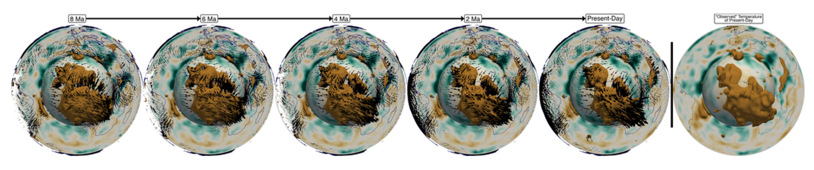
Figure 2- Building a digital twin of Earth’s mantle. The present-day thermal structure of the mantle (rightmost panel) is derived from the REVEAL full-waveform seismic tomography model (Thrastarson et al., 2024) and converted to temperature using the SLB24 thermodynamic framework for mantle minerals (Stixrude & Lithgow-Bertelloni, 2024). This observed temperature field serves as the optimisation target. Using G-ADOPT’s adjoint-based data assimilation framework, an optimal initial temperature field at 10 Ma is recovered such that, when the mantle convection equations are solved forward in time, the simulation reproduces the observed present-day state. The sequence (left to right) shows this forward evolution from 8 Ma to the present day. The close agreement between the simulated present-day field and the tomographically derived target demonstrates that the framework can recover a dynamically consistent evolutionary trajectory of the mantle. We are now working towards extending this to the full Cenozoic to produce a data-constrained digital twin of Earth’s mantle evolution over the past ~60 million years.
In your opinion, what will be the future of geodynamics?
In my view, the answer is straightforward: the future of geodynamics is data-driven. Sooner or later, and perhaps sooner than many expect, solving the forward problem will become routine. The advances in numerical methods, computational power, and software infrastructure are converging to make that inevitable. When that happens, the defining challenge will no longer be whether we can simulate mantle convection or glacial isostatic adjustment at sufficient resolution. It will be whether we can systematically assimilate the observations we have been collecting across every branch of Earth science and integrate them within a dynamic reference frame.
That is where the field is heading, and it changes everything. In a truly data-driven geodynamics, observations are no longer confined to the subdiscipline that collected them. Past ice sheet reconstructions carry direct consequences for the rheology of the mantle beneath them. A prediction of sea-level change in the Pacific by the end of this century becomes inseparable from how we understand periods of uplift and denudation in Southern Africa, because the same mantle system connects them. The physics does not respect our disciplinary boundaries, and our methods should not either.
The future, I believe, belongs to frameworks that produce models which are globally consistent, dynamically coherent, and honest about their uncertainties. That is the geodynamics I want to help build.
What advice do you have for early-career researchers who would like to continue
their careers in geodynamics?
Honestly, I am not sure I am in a position to give advice. I still learn constantly from the talented early-career colleagues around me. But if I could go back and say something to myself in the first year of my PhD, it would be this: focus on what matters and try not to be distracted by the noise.
In geodynamics, as in any field, there can be pressure to chase short-term outcomes: the next publication, the next metric, the next deliverable. That pressure is real, and I do not want to pretend it can simply be ignored. But the work that endures, the work that I have found most rewarding, has always come from staying close to the fundamental science, from asking questions because they are genuinely interesting, not because they are strategically convenient. The problems worth solving in geodynamics are deep and long-lived. They will still be there when the noise has passed.
And of course, like most things in life, it is about balance. Protect the time for curiosity, but do not be naive about the realities of a career. If I have learned anything, it is that the two are not as incompatible as they sometimes feel.
References:
[1] Thrastarson, S., van Herwaarden, D. P., Noe, S., Josef Schiller, C., & Fichtner, A. (2024). REVEAL: A global full‐waveform inversion model. Bulletin of the Seismological Society of America, 114(3), 1392-1406. https://doi.org/10.1785/0120230273
[2] Stixrude, L., & Lithgow-Bertelloni, C. (2024). Thermodynamics of mantle minerals–III: the role of iron. Geophysical Journal International, 237(3), 1699-1733. https://doi.org/10.1093/gji/ggae126