Every 8 weeks we turn our attention to a Remarkable Region that deserves a spot in the scientific limelight. After looking at several convergent plate boundaries, this week the focus lies on part of a nascent divergent plate boundary: the Kenya Rift. The post is by postdoctoral researcher Anne Glerum of GFZ Potsdam.
Of course an active continental rift is worthy of the title “Remarkable Region”. And naturally I consider my own research area highly interesting. But after seeing it up-close and personal on a recent 10-day trip organized by the University of Potsdam, Roma Tre and the University of Nairobi (stay tuned for the travel log, or read that of the University of Potsdam), I must say, the Kenya Rift is a truly beautiful and fascinating region.
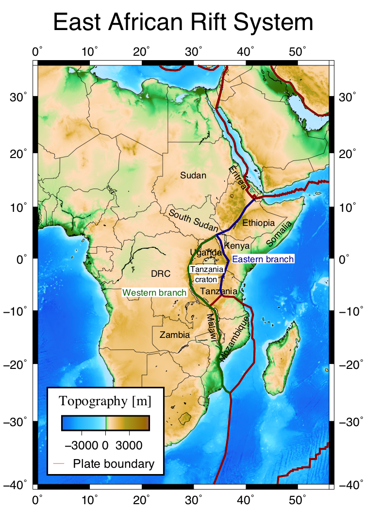
Figure 1. Topography (Amante and Eakins 2009) and kinematic plate boundaries (Sarah D. Stamps based on Bird 2003) of the East African Rift System (EARS). Plate boundary colors schematically indicate the western and eastern branches of the EARS.
Constituting one segment of the 5000 km long East African Rift System (EARS, Fig. 1), the Kenya Rift is host to an amazing landscape, wildlife and people, all of which somehow tie back to continental rifting processes. Although the youngest rifting phase in Kenya commenced in the Miocene, the east African region as a whole has been shaped by rifting episodes since Permian times (Bosworth and Morley 1994). The present active rift system runs from the Afar region in the north all the way south to Mozambique and is split into a western and an eastern branch that run around the Archean Tanzanian Craton (Chorowitz 2005, see Fig. 1). Generally speaking, the western branch is more seismically active, but deprived of magmatism, compared to the eastern branch, of which the Kenya Rift is part (Chorowitz 2005). Three processes characterize the EARS (Burke 1996) as well as the Kenya Rift specifically: normal faulting, volcanism and uplift.
Uplift
The Tanzanian Craton together with the enveloping western and eastern EARS branches constitutes the broad, uplifted area coined the East African Plateau (~1200 m elevation, Strecker 1991; Simiyu and Keller 1997, Fig. 2). The onset of uplift of this plateau can be constrained to the Early Miocene with the help of one of the longest phonolitic lava flows on Earth (> 300 km, Wichura et al. 2010; 2011) and a whale that stranded inland 17 Ma (and was only recently found again after going missing for 30 years, Wichura et al. 2015). Plume-lithosphere interaction is thought responsible for the uplift (e.g. Wichura et al. 2010), although there is disagreement about the continuity of the low seismic velocity anomalies seen in the east African upper mantle and whether they are connected to the lower mantle. For example Ebinger and Sleep (1998), Hansen et al. (2012), Sun et al. (2017) and Torres Acosta et al. (2015) advocate for one East African superplume, while Pik et al. (2006) distinguish separate lower and upper mantle plumes and Davis and Sack (2002) and Halldórsson et al. (2014) consider a lower mantle plume splitting in the upper mantle.
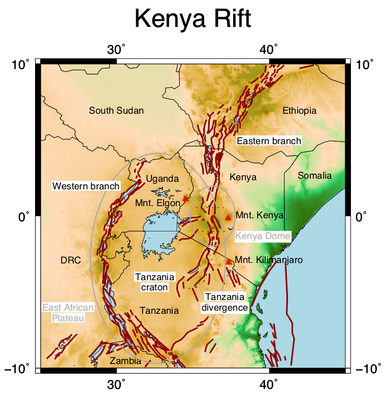
Figure 2. Topography (Amante and Eakins 2009) and fault traces (GEM) of the central EARS. Triangles indicate off-rift volcanoes, dotted grey lines the three segments of the Kenya Rift.
Magmatism and volcanism
The northward motion of Africa over this hot mantle anomaly has been thought the cause of a north-to-south younging trend in the age of the ensuing EARS volcanism and rifting (e.g. Ebinger and Sleep 1998; George et al. 1998; Nyblade and Brazier 2002), although more recent studies arrive at a more spatially disparate and diachronous rifting evolution (Torres Acosta et al. 2015 and references therein). In general, massive emplacement of flood-phonolites preceded the onset of rifting in Kenya around 15 Ma (Torres Acosta et al. 2015). With ongoing rifting, and localization of faulting towards the rift axis, volcanism also migrated towards the center of the rift. Since the Miocene, massive amounts of volcanics have thus been emplaced (144,000-230,000 km3, MacDonald 1994; Wichura et al. 2011). Moreover, dyking also accommodated a significant part of the extension, with 22 to 26 % of the crust in the rift valley being composed of dykes (MacDonald 2012). Not surprisingly, the highlands directly around the rift valley, the Kenya Dome (Fig. 2) formed through a combination of volcanism and uplift (Davis and Slack 2002) with elevations of up to 1900 m.
The composition of rift magmatism is bimodal, showing phonolites and trachytes on the one side and nephelinites and basalt on the other, predominantly resulting from fractional crystallization of a basaltic source. The low viscosity of these magmas allows the young volcanoes in the volcano-tectonic axis to reach significant heights (see Fig. 3; MacDonald 2012). The most impressive volcanoes are to be found outside of the rift however (Fig. 2), with Mnt. Elgon reaching 4321 m and Africa’s highest mountains Mnt. Kenya and Mnt. Kilimanjaro reaching up to 5200 m and 5964 m, respectively (Chorowitz 2005).
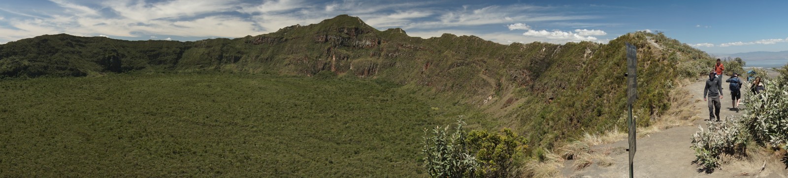
Figure 3. View on the crater rim of the 400 ky old Mnt. Longonot volcano in the tectono-magmatic rift axis, at 2560 m asl. Courtesy of Corinna Kallich, GFZ Potsdam.
Normal faulting
The Kenya rift itself is composed of 3 asymmetric segments, distinguished by sharp changes in their orientation (Chorowitz 2005, Fig. 2). The 2300-3000 m high Elgeyo, Mau and Nguruman escarpments result from the steep Miocene east-dipping border faults in the west, while the antithetic border faults on the eastern side formed later during the Pliocene (Strecker et al. 1990). The older border faults formed along preexisting foliation generated by the Mozambique Belt orogeny in the late Proterozoic (Shackleton 1993; Hetzel and Strecker 1994). A change in strike of this foliation from NNE in the northern and southern Kenya rifts to NW determined the change in orientation in the central Kenya rift (Strecker et al. 1990). Consequently, different generations of faults in the northern and southern rift segments run parallel, while in the central segment, the Pleistocene change in extension direction from ENE-WSW/E-W to the present-day WNW-ESE/NW-SE directed extension results in obliquely reactivated border faults and younger, en echelon arranged left-stepping NNE-striking fault zones along the rift axis (Strecker et al. 1990). Extension is transferred between the different zones by coeval normal and strike-slip faulting or dense sets of normal faults.
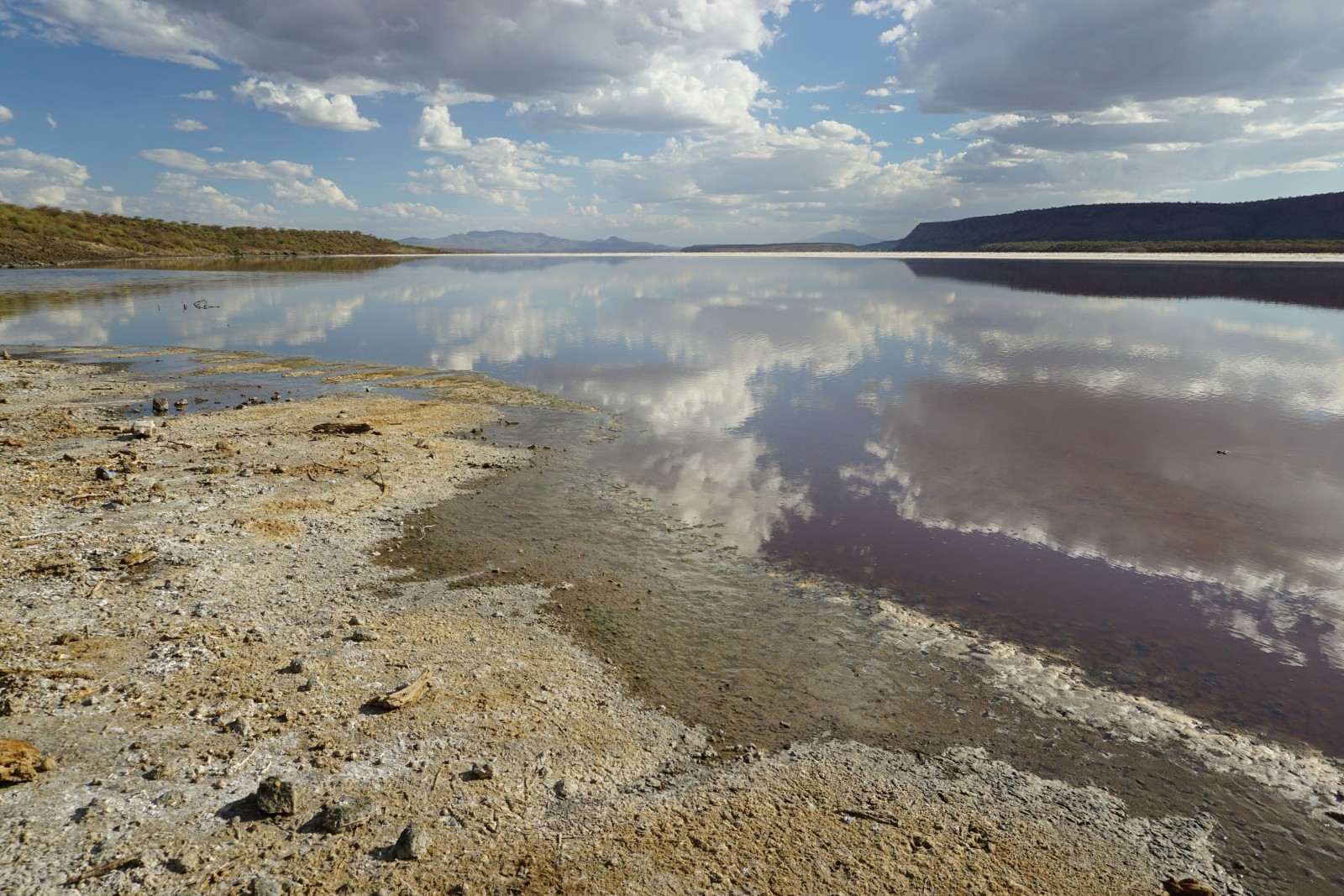
Figure 4. View of lake Magadi and the Nguruman escarpment. Lake Magadi is a saline, alkaline lake, commercially mined for trona. Courtesy of Corinna Kallich, GFZ Potsdam.
Human evolution
The uplift, volcanism and normal faulting together have set the stage for human and animal evolution. For example, the shift in hoofed mammals from eating predominantly woods to grazing species evidences that the large-scale uplift modified air circulation patterns resulting in aridification and savannah-expansion at the expense of forested areas (Sepulchre et al. 2006; Wichura et al. 2015). The rift basins enabled the formation of large lakes, which were subsequently compartmentalized by tectonic and volcanic morphological barriers (Fig. 4). On the short-term, lake coverage varied due to tectonically induced changes in catchment areas, drainage networks and outlets. Maslin et al. (2014) actually found a correlation between this ephemeral lake coverage and hominin diversity and dispersal. Lake highstands link with the emergence of new species and allowed the spread of hominins north and southward out of east Africa. Remarkable, or what!
References:
Amante, C. and Eakins B. W., 2009. NOAA Technical Memorandum NESDIS NGDC-24. National Geophysical Data Center, NOAA.
Bosworth, W. and Morley, C.K., 1994.  Tectonophysics 236, 93–115.
Burke, K., 1996. S. Afr. J. Geol. 99 (4), 339–409.
Chorowitz, J., 2005. J. Afr. Earth Sci. 43, 379-410.
Davis, P. M. and Slack, P. D. 2002. Geophys. Res. Lett. 29 (7), 1117.
Ebinger, C.J. and Sleep, N.H., 1998. Nature 395, 788-791.
George, R. et al., 1998.  Geology 26, 923–926.
Halldórsson, S. A. et al., 2014. Geophys. Res. Lett. 41, 2304–2311,
Hansen, S. E. et al., 2012.  Earth Planet. Sc. Lett. 319-320, 23-34.
Hetzel, R., Strecker, M.R., 1994. J. Struct. Geol. 16, 189–201.
Macdonald, R. et al., 1994a. J. Volcanol. Geoth. Res. 60, 301–325.
Macdonald, R., et al., 1994b. J. Geol. Soc. London 151, 879–888.
MacDonald, R., 2012. Lithos 152, 11-22.
Maslin, M. A. et al., 2014. Quaternary Sci. Rev. 101, 1-17.
Nyblade, A. A. and Brazier, R. A., 2002. Geology 30 (8), 755-758.
Pik, R. et al., 2006. Chem. Geol. 266, 100-114.
Sepulchre, P. et al., 2006. Science, 1419-1423.
Shackleton, R.M., 1993. Geological Society, London, Special Publications 76, 345–362.
Simiyu, S.M., Keller, G.R., 1997. Tectonophysics 278, 291–313.
Strecker, M., 1991. Das zentrale und südliche Kenia-rift unter besonderer berücksichtigung der neotektonischen entwicklung, habilitation, Universität Fridericiana.
Sun, M. et al., 2017.  Geophys. Res. Lett. 44, 12,116–12,124.
Torres Acosta, V. et al., 2015. Tectonics 34, 2367–2386.
Wichura, H. et al., 2010. Geology 38 (6), 543–546.
Wichura, H. et al , 2011. The Formation and Evolution of Africa: A Synopsis of 3.8 Ga of Earth History, eds. D. J. J. Van Hinsbergen, S. J. H. Buiter, T. H. Torsvik, C. and Gaina, S. J.
Wichura, H. et al., 2015. P. Natl. Acad. Sci. USA 112 (13), 3910-3915.