Flood hazards often turn destructive and cause substantial loss of life and assets. Annually floods cause significant damage; for example, during the last decade of the 20th century, around 100,000 people lost their lives, and more than 1.4 billion people were affected [1]. Historically, flooding has been viewed as a friend and foe of human civilisations. As a good friend, floods bring nutritious, mineral-rich sediments and help increase agricultural production, among several other benefits. But at the same time, some floods turn into monsters and cause severe destruction. Therefore, studying floods has occupied our thoughts for centuries to map and understand the causes and how to minimise the potentially destructive consequences. The scientific investigations seek to answer the problem. Significant work has been done in mastering the science of floods (for example [2, 3, 4, 5, 6]) and refining our understanding of the various types of floods on Earth. Recently, our team has recognised a new feature that makes a region prone to floods, which over the centuries was somehow overlooked in the Kashmir basin [5, 7, 8]. I am talking about faults. Faults are fractures with appreciable movement, which cause the land to subside and uplift. Subsidence during the deformation of the upper portion of the lithosphere makes a region more prone to floods, and it is typically associated with megathrust faults such as the Himalayan Megathrust fault. Routinely, faults dictate the formation of an area’s topography and drainage system and are very important in altering the landscape by making it susceptible to flooding. Therefore, faults can either make a particular region inclined to floods or divert the river streams protecting the area from flood disasters, suggesting that studying the tectonic setting of a region is vital to understanding the floods (for example [9, 10, 11]).
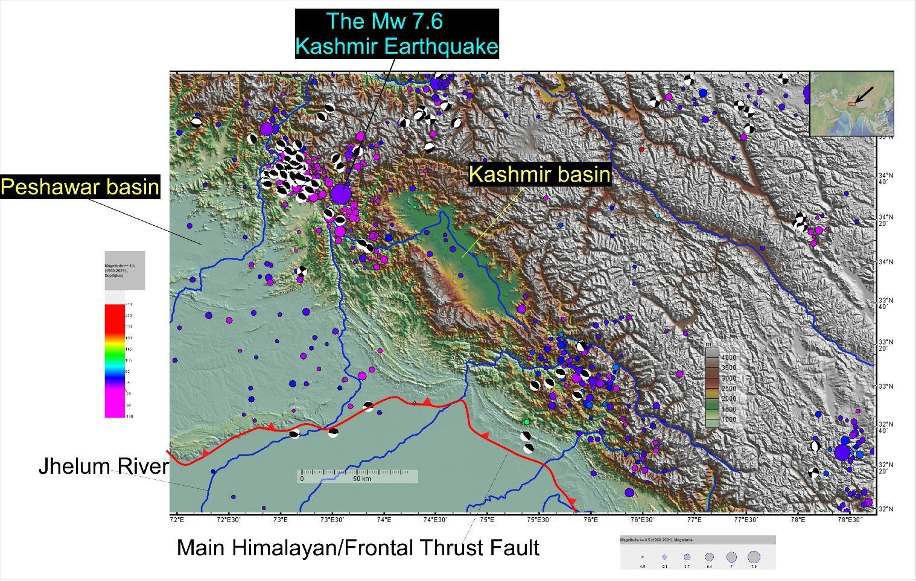
Figure 1. The topographic image of the NW Himlayan shows the piggyback Kashmir basin, which is a prominent topographic low with only one trunk stream, the Jhelum River, flowing through it. The Main Himalayan/Frontal Thrust fault bounds the basin to the south. The coloured dots are earthquakes, and the earthquake centroid moment tensor (CMT) events are plotted as beachballs. The figure was created using the open-source GeoMapApp [19] (http://www.geomapapp.org).
From a geologist’s point of view, earthquakes have primarily shaped the land that is our home. The Kashmir basin, like many other basins in the world, owns its existence to thrust faulting, which has formed a piggyback basin during the Himalayan orogeny. The earthquake occurrences in the region are a direct response to the collisional tectonics (Fig. 1), and the earthquake centroid moment tensor (CMT) events suggest the dominance of NE dipping thrust faulting (Figs. 1 and 4).
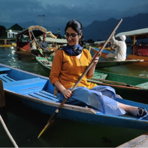
Figure 2. Muhsana Mahoor, one of the young geologists from Kashmir, is enjoying a Shikara (boat) ride on a cloudy day on the clear blue waters of Dal Lake, the famous tourist destination of Kashmir. Muhsana Mahoor kindly shared the photograph.
The Kashmir Basin is filled with Karewas, plateau-like features mainly composed of lacustrine, glacial, and fluvial sediments deposited during the uplift related to India’s ongoing collisional tectonic convergence with Eurasia. The thickness of the sediments is around 1300 meters, and the age of deposition is around 4Ma ago [12]. The Karewas are scattered throughout the basin and preserve evidence of active faulting, which has inclined them towards the NE-directed tilt [5]. The uplift post-dates their formation and suggests active faulting in the southwest [5, 7]. The NE tilt of the basin is remarkable (Fig. 4) and is the primary cause of the characteristic drainage patterns. The streams in the uplifted portions are energetic and have carved deep gorges and canyons, while the streams in the subsided parts are sluggish and often backfilled with sediments [5, 13, 7]. The NE tilt related to NE dipping reverse faulting has created a distinctive pattern of landforms and forced the trunk stream, Jhelum River, to shift towards the subsided regions (Fig. 1). Therefore, the streams towards the northeast of the Jhelum River are backfilled with sediments and cannot cause similar river erosion as in the southwest streams. Moreover, the sediments derived from the tributary rivers are deposited in the Jhelum River, causing siltation and enhancing its flooding potential. The siltation is more abundant in subside regions, which are northeastern portions, and it was possible to foresee that these regions would be prone to floods because of the tilt related to faults that shoulder the basin (Fig. 4) [5].
In 2014, a large flood caused the submergence of a large portion of the valley in the Kashmir basin, and the flooding pattern mimicked the basin’s topography, as forecasted [5, 7]. The cause of flooding was mainly related to climate change and urbanization without linking the role of the predisposed structural setup of the basin [8]. However, the region has been historically impacted by large floods before human-induced climate change, and strong urbanisation worsened the situation. Dating back more than 100 years, the review of the regional historical data on floods [7, 13, 14, 15, 16, 17, 18] supports the idea that the region is inherently prone to floods because of the tilting associated with thrust faulting (Fig. 4).
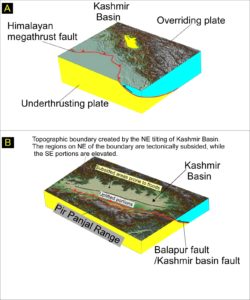
Figure 4A. The 3D topography of the NW Himlayan shows the piggyback Kashmir basin (yellow polygon). The Main Himalayan/Frontal Thrust fault bounds the basin to the south. The basin is part of the overriding plate, and as such, it is constantly under the influence of tectonic uplift and subsidence. Figure 4B shows the 3D topography of the basin with subsided and elevated portions related to the internal faults within and south of it. The figure was created using the open-source GeoMapApp [19] (http://www.geomapapp.org).
To conclude, it is essential to understand that during orogenesis, the basin formation is often controlled by faulting and folding, which dictates the uplift and subsidence that relates to the situation of flooding in the tributary and the truck stream. The uplift causes erosion and downcutting, and subsidence causes siltation, backfilling of streams, and deposition of sediments in the rivers. These factors are the critical components of the flood situation in rivers, which will be enhanced by urbanisation, and climate change-related factors. Therefore, studying flooding in Kashmir makes a strong case for reviewing the existing flood models where topography may not have been considered and could be the key factor to unlocking the science of floods.
References
[1] Jonkman, S. N. (2005). Global perspectives on loss of human life caused by floods. Natural hazards, 34(2), 151-175. https://doi.org/10.1007/s11069-004-8891-3
[2] Van Dantzig, D. (1956). Economic decision problems for flood prevention. Econometrica: Journal of the Econometric Society, 276-287. https://doi.org/10.2307/1911632
[3] Shah, B. V.: 1983, Is the environment becoming more hazardous? – A global survey 1947– 1980, Disasters 7, 202–209. https://doi.org/10.1111/j.1467-7717.1983.tb00822.x
[4] Pielke, R. A. Jr.: 1999, Nine fallacies of floods, Climatic Change 42, 413–438. https://doi.org/10.1023/A:1005457318876
[5] Shah AA (2013) Earthquake geology of Kashmir Basin and its implications for future large earthquakes. International Journal of Earth Sciences. 102:957–1966. https://doi.org/10.1007/s00531-013-0874-8
[6] Kasmalkar, I. G., Serafin, K. A., Miao, Y., Bick, I. A., Ortolano, L., Ouyang, D., & Suckale, J. (2020). When floods hit the road: Resilience to flood-related traffic disruption in the San Francisco Bay Area and beyond. Science advances, 6(32), eaba2423. https://doi.org/10.1126/sciadv.aba2423
[7] Shah AA (2016) The Kashmir Basin fault and its influence on the fluvial flooding in the Kashmir Basin, NW Himalaya. Geological Society of America Special Papers 520. https://doi.org/10.1130/2016.2520(28)
[8] Shah A.A., Batmanathan N.M., Qadir A., Kumar R. (2022) Flood Hazards in the Jhelum River Are Mainly Controlled by the Piggyback Thrusting of the Kashmir Basin and Less so by Factors like Climate Change and Urbanization. In: Rani S., Kumar R. (eds) Climate Change. Springer Climate. Springer, Cham. https://doi.org/10.1007/978-3-030-92782-0_7
[9] Ouchi, S. (1985). Response of alluvial rivers to slow active tectonic movement. Geological Society of America Bulletin, 96(4), 504-515. https://doi.org/10.1130/0016
[10] Snyder, N. P., Whipple, K. X., Tucker, G. E., & Merritts, D. J. (2003). Channel response to tectonic forcing: field analysis of stream morphology and hydrology in the Mendocino triple junction region, northern California. Geomorphology, 53(1-2), 97-127. https://doi.org/10.1016/S0169-555X(02)00349-5
[11] Hughes, M. W., Quigley, M. C., Van Ballegooy, S., Deam, B. L., Bradley, B. A., Hart, D. E., & Measures, R. (2015). The sinking city: Earthquakes increase flood hazard in Christchurch, New Zealand. GSA Today, 25(3), 4-10. https://doi.org/10.1130/GSATG221A.1
[12] Burbank DW, Johnson GD (1983) The late Cenozoic chronologic and stratigraphic development of the Kashmir intermontane basin, northwestern Himalaya. Palaeogeography, Palaeoclimatology, Palaeoecology 43(3-4):205-235. https://doi.org/10.1016/0031-0182(83)90012-3
[13] Shah AA (2015) Assessing the influence of watershed characteristics on the flood vulnerability of Jhelum Basin in Kashmir Himalaya by Gowhar et al., 2015. Natural Hazards 77(3):2139-2143. https://doi.org/10.1007/s11069-015-1775-x
[14] Rajatarangini Kalhanas, 1149, n.d Translated by Dutt (1879) Kings of Káshmír: Being a Translation of the Sanskrita Work Rájatarangginí of Kahlana Pandita in Ballesteros-Cánovas, A., Koul T, Bashir A, Maria J et al (2020) Recent flood hazards in Kashmir put into context with millennium-long historical and tree-ring records. Science of The Total Environment 1-9 (2020). https://doi.org/10.1016/j.scitotenv.2020.137875
[15] Lawrence WR (1895) The Valley of Kashmir. Oxford, UK, Oxford University Press 205–219.
[16] Bilham R, Bali BS, Bhat MI, Hough S (2010) Historical earthquakes in Srinagar, Kashmir: clues from the Shiva temple at Pandrethan. Geol Soc Am Spec Pap 471:107–117. https://doi.org/10.1130/2010.2471(10)
[17] Ballesteros-Cánovas, Antonio J, Koul T, Bashir et al (2020) Recent flood hazards in Kashmir put into context with millennium-long historical and tree-ring records. Science of The Total Environment 722:1-9. https://doi.org/10.1016/j.scitotenv.2020.137875
[18] Oreskes N (2004) Beyond the ivory tower: The scientific consensus on climate change Science 306:1686. https://doi.org/10.1126/science.1103618
[19] Ryan, W.B.F., S.M. Carbotte, J.O. Coplan, S. O’Hara, A. Melkonian, R. Arko, R.A. Weissel, V. Ferrini, A. Goodwillie, F. Nitsche, J. Bonczkowski, and R. Zemsky (2009), Global Multi-Resolution Topography synthesis, Geochem. Geophys. Geosyst., 10, Q03014, https://doi.org/10.1029/2008GC002332.
Post edited by Shreya Arora, Asimina Voskaki and Paulo Hader