From the very early years on this Planet, earthquakes have always captivated people’s attention. The feeling of admiration and fear always lies within us, especially drawing on the most recent megathrust earthquake that hit the south coast of Kamchatka’s Peninsula, in Russia, twice this year. Therefore, in this week’s blog, we aim to explore how this phenomenon evolved and why this specific region in the Pacific, known as the Ring of Fire, is one of the world’s most active regions generating earthquakes and volcanic eruptions.
Unfolding the Chronicle of Kamchatka’s Region Megathrust Earthquake
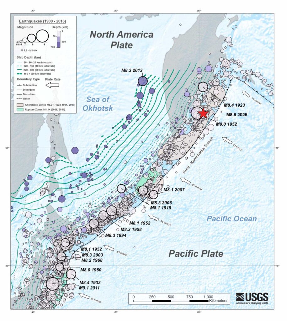
Fig.1: A seismic map shows the epicentre of a major earthquake that hit the far east coast of the Kamchatka Peninsula on the 29th of July 2025, as well as all the earthquakes that occurred in the broader region from the 1900s till 2016. Source: (USGS, 2025).
On July 29, 2025, a massive magnitude 8.8 earthquake struck at a depth of 35 km off the far eastern coast of Russia’s Kamchatka Peninsula (USGS, 2025). It was one of the strongest earthquakes recorded in modern history, occurring in one of the most seismically active regions on Earth. Tsunami alerts were issued not only across the Pacific Coast — including Japan, Hawaii, and the U.S. West Coast — but also for more distant areas, such as Indonesia, China, Peru, and New Zealand. Millions of people were evacuated from coastal areas to higher ground as a precaution (BBC, 2025). Fortunately, damage and injuries near the epicentre were relatively limited, and the tsunami warning was lifted, since there was no further danger.
However, what is more interesting to see is that less than two months later, September 18, 2025, another strong earthquake —magnitude 7.8 at a depth of 19.5 km — struck the same region (USGS, 2025). Classified as an intense aftershock caused by shallow reverse faulting, it again triggered tsunami warnings around the Pacific, but resulted in no significant damage (Al Jazeera, 2025). In conclusion, it is essential to emphasise that this region can generate intense and large-magnitude earthquakes that should be constantly monitored for the benefit of both the scientific community and society at large.
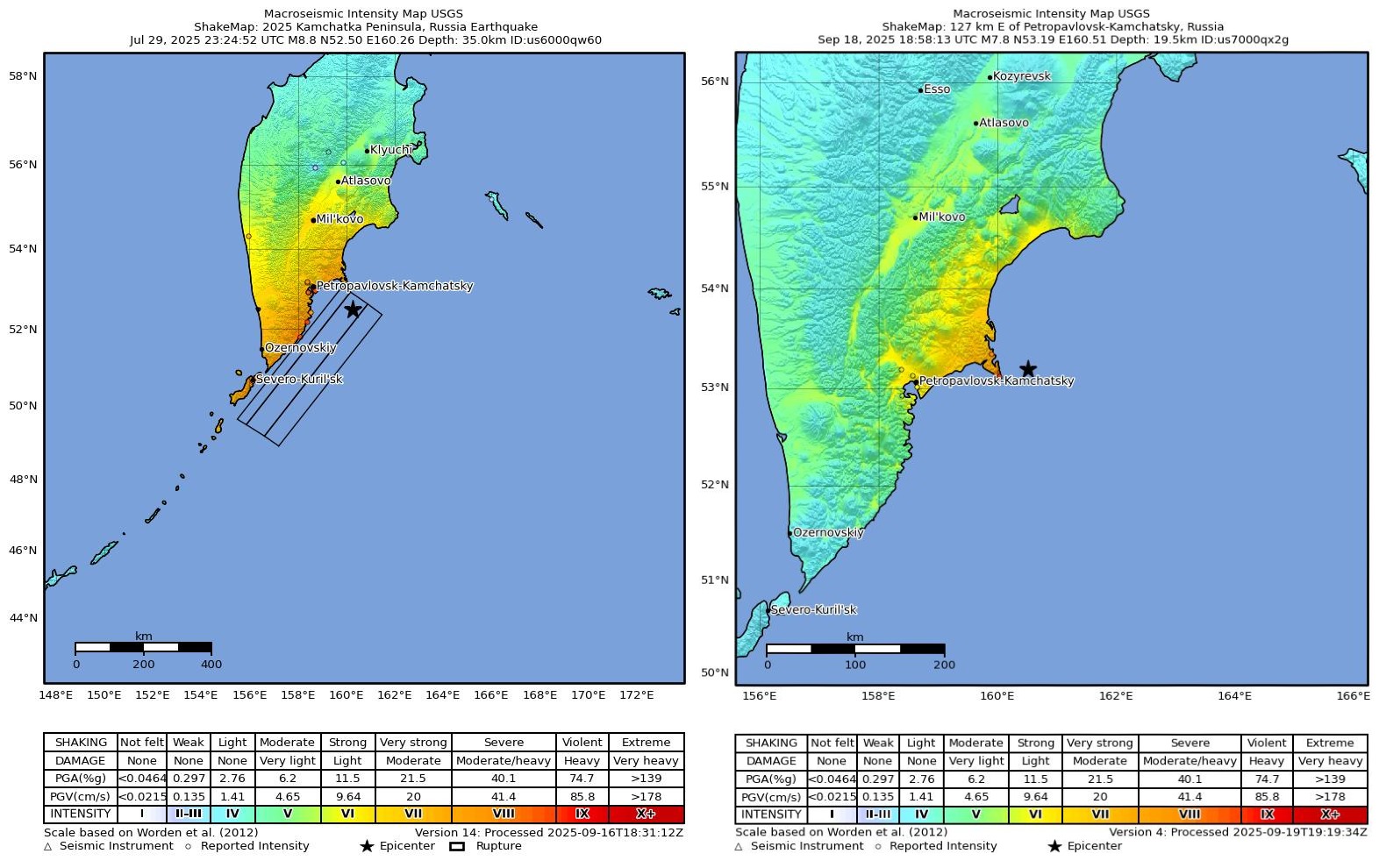
Fig.2: Macroseismic Map Intensity for the two quakes that occurred on July 29 and September 18, 2025, in the Kamchatka Peninsula. Source: (USGS, 2025).
Why this Seismic Event Matters?
These earthquake episodes raise important questions: why are they significant, and what can they teach us about future preparedness?
First of all, it is essential to understand where this unique region lies in terms of its geological evolution. The Kamchatka Peninsula is located in the north-eastern part of Eurasia and extends to the south-west for approximately 1,200 km (Abramenkov, 2021). This diverse region with the mystifying beauty of alpine lakes and glaciers is situated right at the subduction zone of the Pacific Plate under the Okhotsk microplate (USGS, 2025).
As can be depicted in Figure 3, this subduction process has created the Kuril Islands chain, where the emerging volcanoes span the entire arc and the deep Kuril-Kamchatka Trench. In relation to this tectonic movement of the stationary North American plate, the Pacific plate is moving northwest with its speed increasing from about 79 mm per year at the arc’s northern end to around 83 mm per year near Hokkaido (USGS, 2025).
The Kuril-Kamchatka Arc ranks among the most seismically active areas on Earth. This region is characterised by intense geodynamic and tectonic movements that cause frequent and major earthquakes across the subduction zone. According to the US Geological Survey, this particular area has frequently experienced large quakes (M≥7-8).
More precisely, the deformation of the overriding North American plate and its associated microplates produces shallow crustal earthquakes, while movement along the subduction zone interface between the Pacific and North American plates triggers interplate earthquakes that occur from near the trench base down to depths of 40–60 km. The largest megathrust earthquake of the 20th century along this arc was the 1952 M9.0 event, the fifth-largest recorded earthquake to date, which caused a devastating tsunami up to 12 m high at Paramushir and severe damage in Severo-Kurilsk (USGS, 2025).
For that reason, given the region’s high tectonic activity, establishing robust systems to monitor both seismic and volcanic activity is crucial. Such data are vital for improving emergency response and resilience during crises.
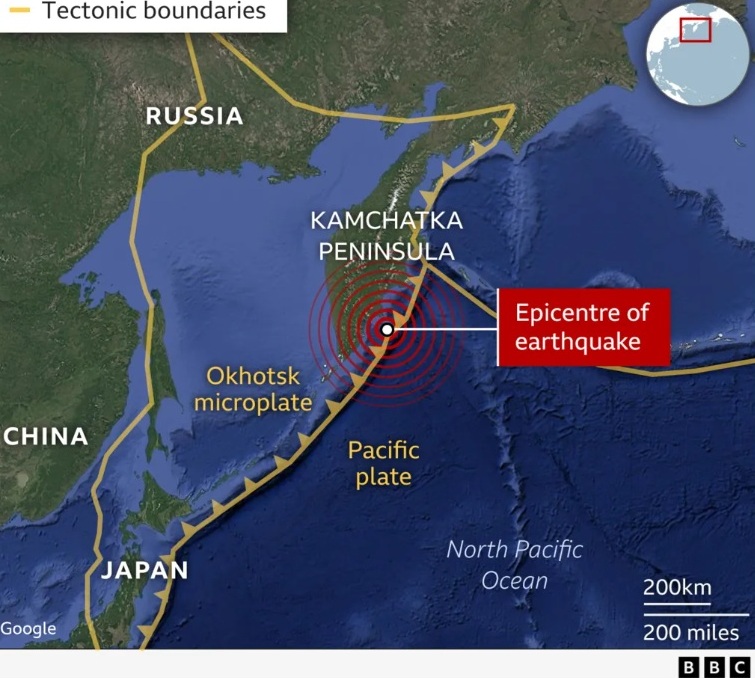
Fig.3: Tectonic map illustrating the Pacific plate subduction under the Okhotsk microplate, and the epicentre of the recent Earthquake in the region. Source: (BBC, 2025).
The Pacific Ring of Fire: Revealing the secrets behind the world’s most active region
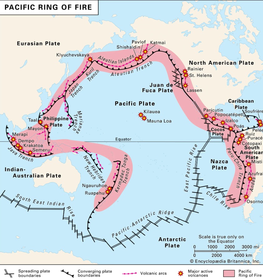
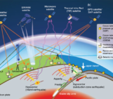
Fig.4: The map illustrates the Ring of Fire, which is a zone of active volcanoes, volcanic arcs and tectonic plate boundaries encircling the Pacific Ocean. Source: (Encyclopaedia Britannica, 2025).
The Kamchatka Peninsula lies in one of the world’s most active tectonic regions, which is called ‘The Pacific Ring of Fire’, an arc that extends along the plate boundaries around the Pacific Ocean (USGS, 2025).
The Ring of Fire is a vast, horseshoe-shaped zone of intense seismic and volcanic activity around the Pacific. Stretching about 40,000 km, it follows island arcs such as Tonga, Indonesia, the Philippines, Japan, the Kuril Islands, and the Aleutians, as well as arc-shaped regions like the Andes and the western coast of North America (Encyclopaedia Britannica, 2025).
Marked by deep ocean trenches on its seaward side and continental landmasses behind, the active zone hosts about 75% of the world’s volcanoes and approximately 90% of its largest earthquakes (National Geographic, 2025).
The Ring of Fire is a product of plate tectonics formed over millions of years. Earth’s crust is made up of massive, puzzle-like plates that continually shift over the mantle’s solid and molten layers. Where these plates collide, separate or slide past one another—especially around the Ring of Fire—intense geological activity occurs (National Geographic, 2025).
That is why this region effectively serves as an ‘open laboratory’ for scientists to investigate seismic processes and develop strategies to build resilience against future hazards.
What we learned from the Kamchatka Earthquake
The Kamchatka earthquake reminded us of the power of natural phenomena and how immediate response and good training can help us deal effectively with any future risks.
Undoubtedly, its massive magnitude and offshore location raised widespread fears of a Pacific-wide tsunami. Tsunami waves reaching up to 4 m were recorded in Russia and Alaska, but they did not cause catastrophic damage. (NDTV World, 2025).
What made a significant difference in this event was the immediate issuance of tsunami warnings and evacuation alerts to coastal communities across the Pacific (BBC, 2025). The importance of having early warning systems can make a tangible difference in disaster response. By contrast, the 2004 Indian Ocean earthquake struck without a tsunami warning system in place, leaving no time to evacuate, and resulting in a devastating loss of life.
For that reason, this underscores the urgent need to strengthen early warning systems in geologically active regions and ensure that both authorities and the public know how to respond. Moreover, scenario simulations and disaster preparedness planning can further improve resilience to future hazards. Although earthquakes cannot yet be predicted, ongoing monitoring and data collection can help estimate the probability of future events (McNeill, 2025).
After all, we should always keep in mind that prevention is always better than cure, so this means that we are capable of successfully tackling such incidents in the foreseeable future.
References

Abramenkov, S. (2021). Systematic analysis of long-period earthquakes: Gorely volcano, Kamchatka. Earth Sciences. Université Paris Cité. English. ffNNT : 2021UNIP7002ff. fftel-03788405ff

Aljazeera. Magnitude 7.8 quake shakes Russia’s Far East region, prompts tsunami alert. https://www.aljazeera.com/news/2025/9/19/magnitude-7-8-quake-shakes-russias-far-east-region-prompts-tsunami-alert. Accessed: 16th Sep 2025.

BBC. Waves reach US west coast after Russian earthquake as Japan lifts tsunami warnings. https://www.bbc.com/news/live/c3r4x9yrrg4t. Accessed: 16th Sep 2025.

BBC. Why did Russian mega earthquake not cause more tsunami damage? https://www.bbc.com/news/articles/c0l6pj7kjg7o. Accessed: 17th Sep 2025.

BBC. Why did Russian mega earthquake not cause more tsunami damage? Image. https://www.bbc.com/news/articles/c0l6pj7kjg7o. Accessed: 17th Sep 2025.

Encyclopaedia Britannica. Ring of Fire-seismic belt. https://www.britannica.com/place/Ring-of-Fire. Accessed: 17th Sep 2025.

Encyclopaedia Britannica. Ring of Fire. Image. https://www.britannica.com/place/Ring-of-Fire#/media/1/118426/156997. Accessed: 20th Sep 2025.

 McNeill, L. "Although we can use how fast the plates are moving, GPS to measure current movements and when previous earthquakes occurred, we can only use this information to make forecasts of probability of an earthquake." [Comment on the webpage Why did Russian mega earthquake not cause more tsunami damage?]. BBC News. https://www.bbc.com/news/articles/c0l6pj7kjg7o . Accessed: 20th Sep 2025.

NDTV World. Explained: Ring Of Fire, Where The Strongest Earthquakes Occur. https://www.ndtv.com/world-news/explained-ring-of-fire-where-the-strongest-earthquakes-occur-8982838. Accessed: 15th Sep 2025.

National Geographic. The Ring of Fire. https://www.nationalgeographic.com/science/article/ring-of-fire. Accessed: 18th Sep 2025.

National Geographic. Plate Tectonics and the Ring of Fire. https://education.nationalgeographic.org/resource/plate-tectonics-ring-fire/. Accessed: 20th Sep 2025.

Sergei Abramenkov. (2021). Systematic analysis of long-period earthquakes: Gorely volcano, Kamchatka. Earth Sciences. Université Paris Cité. English. ffNNT : 2021UNIP7002ff. fftel-03788405ff

Unsplash. Image. Map of the World made out of Chocolate. https://unsplash.com/photos/a-map-of-the-world-made-out-of-chocolate-crumbs-WXnoxGfJ9zA. Accessed: 25th Sep 2025.

USGS. Earthquake Hazards Program in cooperation with the U.S. M 8.8 - 2025 Kamchatka Peninsula, Russia Earthquake. https://earthquake.usgs.gov/earthquakes/eventpage/us6000qw60/executive. Accessed: 15th Sep 2025.

USGS. Earthquake Hazards Program in cooperation with the U.S. M 8.8 - 2025 Kamchatka Peninsula, Russia Earthquake. Image. Tectonic Summary. https://earthquake.usgs.gov/earthquakes/eventpage/us6000qw60/executive. Accessed: 15th Sep 2025.

USGS. Earthquake Hazards Program in cooperation with the U.S. M 7.8 - 127 km E of Petropavlovsk-Kamchatsky, Russia https://earthquake.usgs.gov/earthquakes/eventpage/us7000qx2g/executive. Accessed: 15th Sep 2025.

USGS. Earthquake Hazards Program in cooperation with the U.S. M 7.8 - 127 km E of Petropavlovsk-Kamchatsky, Russia. Image. ShakeMap. https://earthquake.usgs.gov/earthquakes/eventpage/us7000qx2g/shakemap/intensity. Accessed: 17th Sep 2025.