In 1995, the Caribbean Island of Montserrat was shaken by the beginning of one of the most significant volcanic eruptions in recent history: one that profoundly changed the natural, social and economical landscape of the country. Three decades later, Soufrière Hills Volcano and its legacy of destruction still shape the lives of Montserrat’s people. Join us on the first part of our reportage and find out more about the island, the volcano and its watchful guardians: the people of the Montserrat Volcano Observatory.
Day 0: just landed in Montserrat
Lorenzo Mantiloni is a post-doctoral researcher at the University of Exeter in the UK. His research interests include the dynamics and stability of dynamic magma-mush reservoirs, as well as modelling of stress and magma pathways in the Earth’s crust and volcanic hazard assessment. You can reach him by e-mail at l.mantiloni@exeter.ac.uk.
Montserrat is a lonely, rocky silhouette when I first spot it. As the tiny aircraft slides over the Caribbean Sea and I peek through the pilot’s windscreen not too far from me, it slowly gets larger, until I can make out the details of its northern side: steep, barren cliffs. Ten minutes later, the tiny aircraft – for it really is tiny, so much that my luggage didn’t make the cut and was left behind in Antigua, with a handful of cheese samples which the ice packs won’t keep cool for long – veers sharply around the island, and I can catch a glimpse at its heart: the villages, the beaches, the harbour and quarries and winding roads, and the lush, omnipresent flora. The plane turns back from the open sea to the coast and with a steadfast, slick descent lands onto the airstrip of John Osborne Airport. A sweet tropical aroma enfolds us as we walk out. Heat and humidity follow suit, but are no big deal: I got used to them hours ago. They are here to stay, though. Peaks and hills covered in forest surround us, as do the hallmarks of human presence: colourful houses, a few taller buildings, a radio mast, cultivations. The border control goes smoothly, and I realise I won’t be changing clothes until tomorrow afternoon: that’s the earliest my luggage can come in. But that’s just a little annoyance. As soon as we are out, our host, Karen Pascal, comes to meet us. With much chagrin I inform her that her cheese is missing; no worries, she says, cheese gets better the later you eat it . Our rental car is ready too. We are soon heading down the hill to a much-awaited dinner in Little Bay. As the sun starts diving for a glorious, though brief, tropical sunset, Montserrat welcomes us with its kindest side. What we came here for is nowhere to be seen, but the clouds seem to be denser to the south. I’ll see it soon enough.
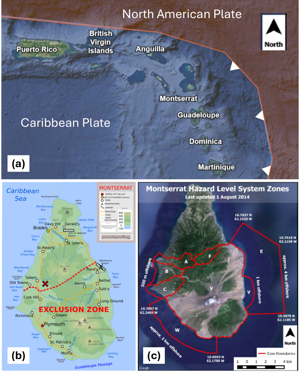
Figure 1: meet Montserrat. a) Location and tectonic context of Montserrat Island (credit: Plate Tectonics Google Map, Mariana Garcia Serrato). b) Map of Montserrat with settlements and points of interest (credit: Wikimedia/Ivan25). Blackburne Airport, Plymouth and most of the villages within the exclusion zone were destroyed or made uninhabitable after 1995. The location of the Montserrat Volcano Observatory is marked with a red cross. c) Satellite map of the island, with the different risk zones outlined (Monteil et al., 2020 [2]).
Day 1: meet the Emerald Isle
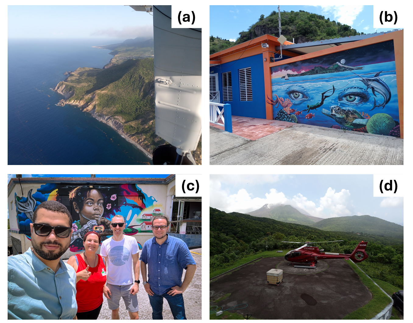
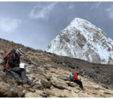
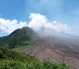
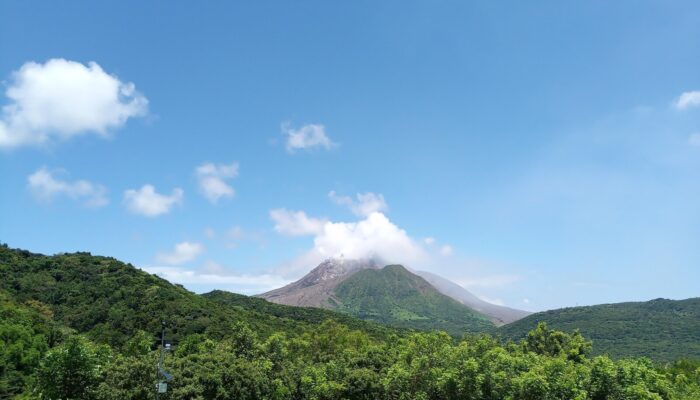
Figure 2: first day on the island. a) View of Hell’s Gate promontory from the flight to Montserrat. Spanish Point and the location of the former airport are visible in the distance. b) Mural at the ferry terminal in Little Bay. c) From left to right: Rami Alshembari, Karen Pascal, James Hickey and me (credit: R. Alshembari). The mural at Victor’s supermarket, with a modern rendition of Chances Peak’s mermaid, is in the background. d) The Montserrat Volcano Observatory helipad, with the landing helicopter and Soufriere Hills Volcano on the horizon. The dome visibility was quite good that day.
The first night goes quietly, despite the lack of fresh garments. The heat doesn’t get any better, but darkness brings about a myriad of sounds from the forest around us. Loudest of all are tiny frogs, invisible but seemingly ubiquitous. At the break of dawn, roosters call from everywhere: they wander the island with confidence, along with goats, cats and iguanas. For our first morning, Karen takes us on a tour of four community murals painted last year around the safe zone: Little Bay’s ferry terminal (Figure 2b), Victor’s supermarket (Figure 2c), the Montserrat Secondary School and Salem’s village centre. They were the creation of a team of artists, local people and schoolchildren, and were commissioned by MVO as part of the “Curating Crises” international project. Their purpose was to depict the relationship between the island, the sea around it, the people in it and volcanism, particularly the volcano in the south. As you may guess, it’s a deep, fascinating and complicated relationship, no short of pain or wonder. And the murals capture it, they really do.
Montserrat owns its current name to a well-known mountain in Catalonia, which came to Columbus’ mind when he encountered it on his second journey. That is just getting started to the island’s vast history. It wasn’t until the 17th century that the first old-world settlers came to the island: a wave of Irishmen, who fled Protestantism from the nearby Saint Kitts. To this day, the island shares a special bond with Ireland – including, incidentally, its other name, “the Emerald Isle”, due to its lush, green appearance. Those first white settlers were followed by European colonisers, mostly English, who soon brought in sub-Saharan African slaves, and sugar cane plantations were the main business for a couple of centuries. Slavery left its painful legacy and a few memories of defiance: in 1768, on Saint Patrick’s Day, a slave uprising was started and soon repressed, but the tree whence its leader was hanged from is now a memorial, and Saint Patrick’s Day is now a ten-day long public holiday. The island was a British colony until the 20th century, with only a few years in total of French occupation during the American Revolutionary War. The remains of coastal forts and defences from that time can still be found, with centuries-old cannons rusting in the grass – no resources to look after them. Agriculture continued to develop, especially in the lush southern region. The island went through slavery abolition, while its society transformed. Indian immigrants added to the melting pot, as it happened in general throughout the Caribbean, leaving a lasting mark on local food. The legacy of the mix – wanted or not – between people of diverse origin over the centuries is also visible in a peculiar shade of green in some people’s eyes (look at the mural in Figure 2b). In the second half of the 20th century, the capital Plymouth thrived as a touristic hotspot and a place of choice for the fancy villas of many international celebrities. AIR Montserrat, a famous residential studio now abandoned to the jungle, hosted artists of the likes of Dire Straits, Rolling Stones and Earth, Wind & Fire. Arrow, an artist from the island, landed an international hit in 1982 that you may be familiar with. SHV was quite different back then. Instead of the massive lava dome that dominates it now, its most prominent feature was the English crater, a sector-collapse scar left by an old eruption (Roobol and Smith, 1998 [3]) and, within it, Castle Peak, a dome formed during the last eruption in the 16th-17th century – a recent one, but still outside of recorded history. There was also a lake, which was said to be home to a mermaid – yes, the girl in the mural at Victor’s supermarket (Figure 2c). Volcanic activity was limited to fumaroles, hot springs and the occasional volcano-tectonic seismic swarm. To the people farming on its flanks, the volcano was nothing more than a source of rich, fertile soil and hot springs. Little did they know how things would change.
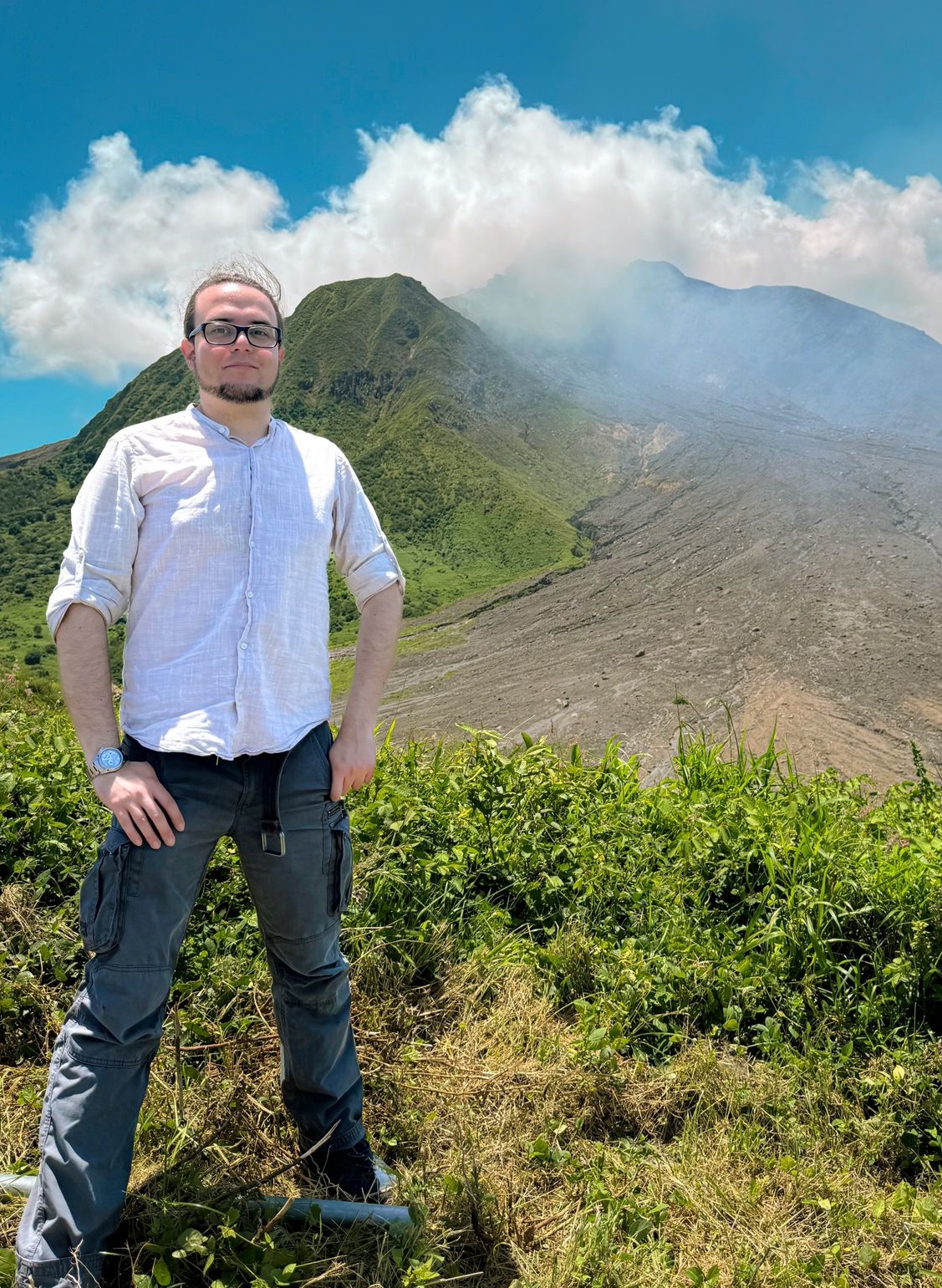
Past the last mural in Salem, I finally meet our case study. It’s there on the horizon: its slopes surprisingly green from this side, the dome cloaked by clouds and the ever-present gas plume. It’s still far – we are still in the safe zone after all – but I can see it now. Several designations for it come to my mind, like “big bad guy”: all childish and wrong. Soufriere Hills is a volcano: the product of a natural process, a force of nature born out of greater forces; we can’t endow it with moral values. Nonetheless, I’m starting to see the point of view of the locals. Before scorching half of the island and displacing much of its population, the unsuspecting mount, with its green slopes, nurtured the community for centuries. Then, in 1995, it turned it into a blight, an oppressor encroaching on their land, something to fear and resent. To me, it’s a natural wonder: fascinating, scientifically challenging, real. As we drive up the steep road to the MVO headquarters, I try to keep both points in mind.
The Montserrat Volcano Observatory
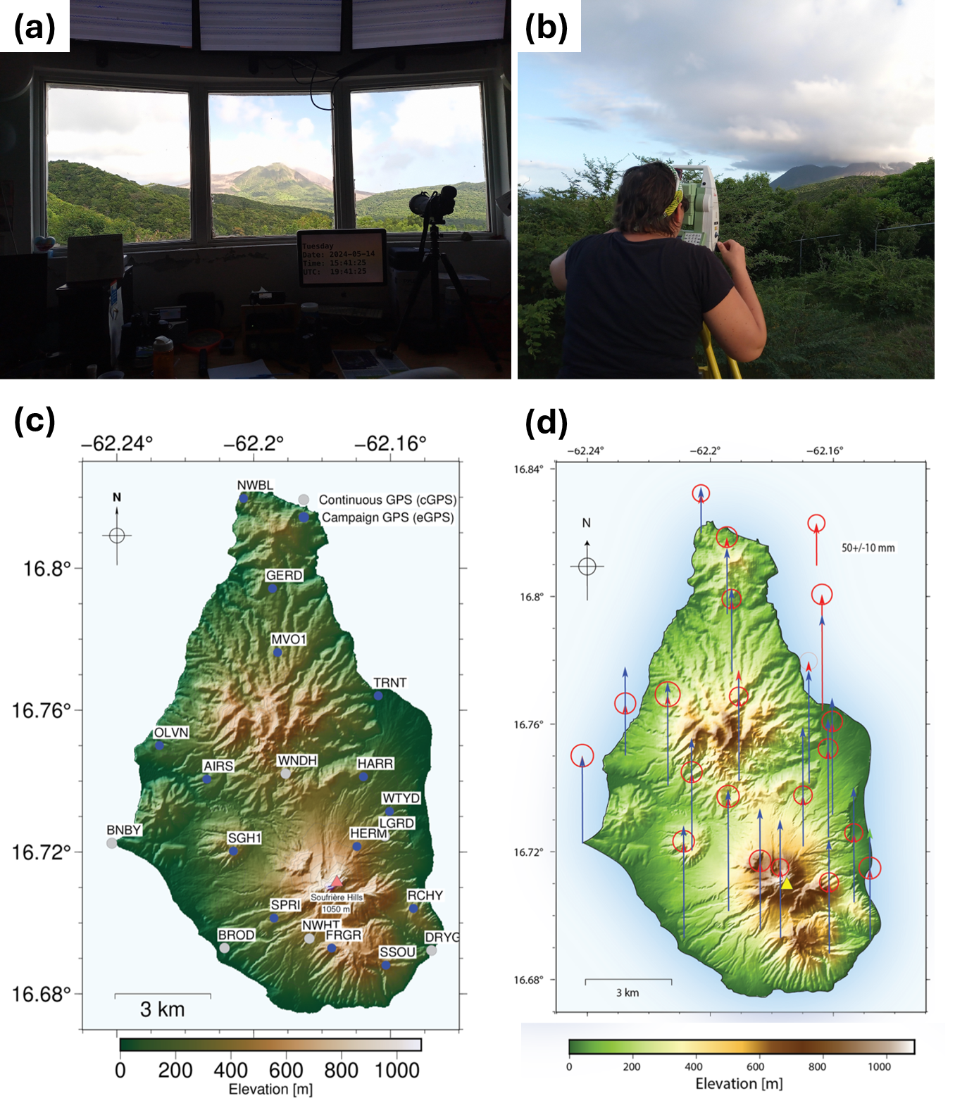
Figure 3: observation and modelling of SHV. a) MVO’s control room, with a clear view on Soufriere Hills Volcano. b) Karen Pascal giving a demonstration of how to perform an Electronic Distance Measurement. The first (and probably hardest) step is to find the refractor on the slope of the volcano, before shooting the laser. c) Map of continuous and campaign GPS stations operating on Montserrat as of 2023. The picture in b) was taken at TRNT station. d) Observed (red) and modelled (blue) vertical displacement at those GPS stations, according to the optimal solution of a deformation source inversion (Alshembari et al., 2024 [6]). c) and d) are modified from Alshembari et al. (2024) [6].
There is a helipad in front of the observatory. Once a week, a helicopter comes to the island for network maintenance and data collection, and spends the day carrying MVO staff and equipment to the volcano and back. Next time, Karen promises us, we’ll join that ride too. As the sun starts to set, we take to the narrow roads again, and I try my best at the wheel, though I can’t match James’ driving skills. On our way to the airport, where my luggage and Karen’s cheese are finally waiting for us, we drive through Salem once more. The border of Zone A – open 24/7 but where minor volcanic hazards could happen – lies not far from here. Further still, the proper exclusion zone begins. Tomorrow, we are going to cross it.
Here ends the first part of the reportage. Stay tuned and join us on January 15th, 2025 for the second part!
Edit: The second Part is now available here !
I dedicate this post to all the people at MVO, to their dedication and resourcefulness, and to the kind and enduring people of Montserrat. May your Emerald Isle thrive once more. I also wish to thank my supervisor James Hickey and my colleague Rami Alshembari for bringing me to this haunting and beautiful corner of the world. A special thank to Karen Pascal, who also helped me revising the post.
The website of the Montserrat Volcano Observatory can be found here. They are very active on social media as well. The University of the West Indies Seismic Research Centre also provides information on the island and the volcano. More information about the community murals and the “Curating Crises” project can be found here. The DV3M project at the University of Exeter is described here.
References:
[1] Roman, D. C., De Angelis, S., Latchman, J. L., & White, R. (2008). Patterns of volcanotectonic seismicity and stress during the ongoing eruption of the Soufrière Hills Volcano, Montserrat (1995–2007). Journal of Volcanology and Geothermal Research, 173(3-4), 230-244. https://doi.org/10.1016/j.jvolgeores.2008.01.014
[2] Monteil, C., Barclay, J., & Hicks, A. (2020). Remembering, forgetting, and absencing disasters in the post-disaster recovery process. International Journal of Disaster Risk Science, 11, 287-299. https://doi.org/10.1007/s13753-020-00277-8
[3] Roobol, M. J., & Smith, A. L. (1998). Pyroclastic stratigraphy of the Soufriere Hills Volcano, Montserrat‐Implications for the present eruption. Geophysical Research Letters, 25(18), 3393-3396. https://doi.org/10.1029/98GL00643
[4] Hickey, J., Pascal, K., Head, M., Gottsmann, J., Fournier, N., Hreinsdottir, S., & Syers, R. (2022). Magma pressurization sustains ongoing eruptive episode at dome-building Soufrière Hills volcano, Montserrat. Geology, 50(11), 1261-1265.  https://doi.org/10.1130/G50239.1
[5] Hickey, J., Pascal, K., Syers, R., & Alshembari, R. (2024). Topographical effects on volcano deformation signal intensity: Implications for GPS network configuration. Geophysical Research Letters, 51(12), e2024GL108812. https://doi.org/10.1029/2024GL108812
[6] Alshembari, R., Hickey, J., Pascal, K., & Syers, R. (2024). Declining magma supply to a poroelastic magma mush explains long-term deformation at Soufrière Hills Volcano. Earth and Planetary Science Letters, 631, 118624. https://doi.org/10.1016/j.epsl.2024.118624
[7] Alshembari, R., Hickey, J., Williamson, B. J., & Cashman, K. (2022). Poroelastic Mechanical Behavior of Crystal Mush Reservoirs: Insights Into the Spatio‐Temporal Evolution of Volcano Surface Deformation. Journal of Geophysical Research: Solid Earth, 127(10), e2022JB024332. https://doi.org/10.1029/2022JB024332
[8] Alshembari, R., Hickey, J., Williamson, B. J., & Cashman, K. (2023). Unveiling the rheological control of magmatic systems on volcano deformation: the interplay of poroviscoelastic magma‐mush and thermo‐viscoelastic crust. Journal of Geophysical Research: Solid Earth, 128(7), e2023JB026625. https://doi.org/10.1029/2023JB026625