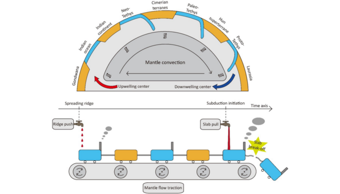
The fundamental of Space Geodesy is the observation of the dynamics of the Earth, such as its rotation on its axis, changes in shape, and the external gravitational field etc., which allow for the monitoring of the Earth system in general. Space Geodetic techniques, such as Global Navigation Satellite Systems (GNSS) / Global Positioning System (GPS), as well as Interferometric Synthetic Aperture R ...[Read More]
Ambient seismic wavefield: how noise can be a signal
Every now and then, the surface of our planet shakes violently during earthquakes like the recent magnitudes 7.8 and 7.5 Kahramanmaraş Earthquake Sequence in Türkiye. These vibrations are recorded by instruments called seismometers and are then processed and analyzed by seismologists to study the earthquake processes themselves as well as other deep Earth structures. Interestingly, seismometers al ...[Read More]
A voyage between different tectonic modelling worlds: from sandbox to supercomputer
Planetary Boundaries: A Framework against Geodynamics?
How can we determine a ‘safe operating space’ for humanity? In this week’s blog, Professor Ilan Kelman from University College London shares his thoughts about Planetary boundaries, and whether this framework will be successful for the next generations to come. The planetary boundaries framework (Rockström et al. 2009ab; Steffen et al. 2015) might be useful for communicating some of humanity’s im ...[Read More]