The ability to easily compile and quickly evaluate both geological and geophysical data is essential for geodynamicists to understand Earth’s evolution. This week Dr. Ben Mather, a Research Fellow at the University of Sydney, introduces us to GPlately, a new tool designed to accelerate spatio-temporal data analysis in GPlates.
GPlately is a Python package that enables the reconstruction of data through deep geologic time (points, lines, polygons and rasters), the interrogation of plate kinematic information (plate velocities, rates of subduction and seafloor spreading), the rapid comparison between multiple plate motion models, and the plotting of reconstructed output data on maps (Figure 1). All tools are designed to be parallel-safe to accelerate spatio-temporal analysis over multiple CPU processors.
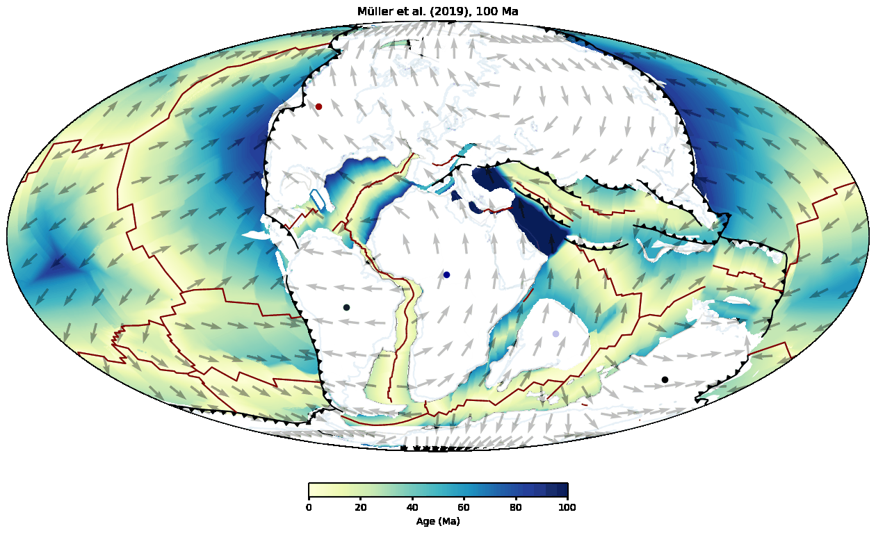
Figure 1: Reconstruction of continents over the last 100 million years using the (Müller et al., 2019) plate model. Five points are attached to separate continents to highlight the relative changes in plate motion.
Why do we need GPlately?

Dr. Ben Mather is a research fellow with the EarthByte Group at the University of Sydney. His research fuses Earth evolution models with geophysical and geochemical data to explain enigmatic volcanism.
The traditional geographic information systems (GIS) interface of GPlates to build and visualize reconstructions has led to wide community adoption, however, the extraction of tectonic information from the graphical user interface (GUI) can be cumbersome or incomplete for spatio-temporal data analysis. The emergence of Python as a widely used scientific programming language brings with it new opportunities to use and interrogate different plate reconstructions. PyGPlates was created to facilitate such spatio-temporal data analysis. PyGPlates is a fine-grained Python interface aimed at exposing the essential plate reconstruction functionality of GPlates to researchers. However, this can be challenging for geoscientists with minimal grounding in Python programming. Even researchers experienced in pyGPlates may find the low-level details cumbersome. Here, we introduce a high-level interface to pyGPlates, which streamlines many of the low-level functions within pyGPlates into a simplified object-oriented package called “GPlately” (Mather et al., 2023).
Installation
pyGPlates + GPlately has never been easier to install. It is available on conda for Windows, Mac, and Linux (including ARM architectures).
conda install -c conda-forge gplately
That’s all! For more detailed instructions check out the GPlately GitHub repository.
Documentation and examples
The GPlately User Manual contains rich documentation on all Python functions and objects within GPlately. GPlately tutorials are in the form of Jupyter Notebooks which document common workflows to reconstruct data, interrogate and compare different plate models, and plotting data on maps. The Jupyter Notebooks are rendered in HTML for quick reference, alternatively download the GPlately GitHub repository to run the notebooks on your own computer. GPlately bundles numerous plate reconstructions published by the EarthByte group and others to quickly get started. Multiple plate models can be defined at the same time, which allows the user to easily compare plate reconstructions.
Example 1: Reconstructing rasters
The need to reconstruct rasters from the present-day back through geological time is a common requirement for many disciplines (e.g. palaeotopography, palaeoclimate). GPlately greatly simplifies this process and will also forward-reconstruct time-coded rasters to the present-day. Simply load any numpy array, netCDF4 grid, or GeoTiff to the gplately.Raster object, setting the plate
model and ‘time’ the raster corresponds to (e.g. time=0 for the present-day), and use the ‘reconstruct’ method to reconstruct the raster back in time (Figure 2). It is then possible to forward-reconstruct in time using a different plate model.
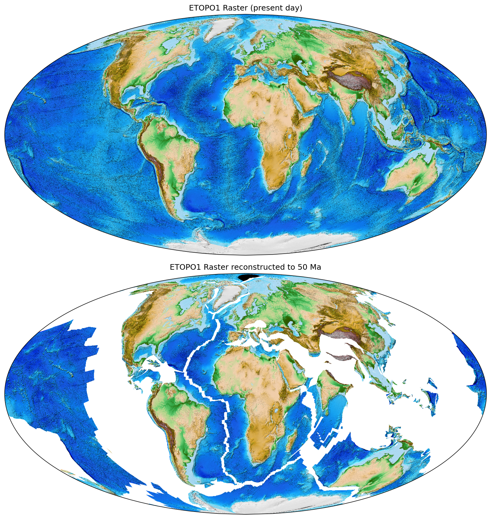
Figure 2: ETOPO1 raster reconstructed to 50 Ma using the Müller et al., 2019 plate model, and forward reconstructed to the present day using the Müller et al., 2016 plate model. This figure can be replicated in Notebook 6 of the GPlately GitHub repository.
Example 2: Reconstructing point data
Using plate reconstructions to examine the palaeolocations of point-wise data on the Earth has wide-ranging applications for numerous data types, such as the geochemistry of rock samples, volcanic edifices, and fossil data. In this example, we select Jurassic Foraminifera from the Paleobiology Database and reconstruct their location back to the Jurassic Period (Figure 3). This is handled by the “Points” object in GPlately, which automatically assigns plate IDs to each of the points read from the static polygons (alternatively a list of plate IDs may be manually assigned). The ordering of reconstructed latitudes and longitudes remain identical to the input coordinates, which preserves the relationship between them and other attributes which may be stored in a pandas dataframe or ESRI shapefile.
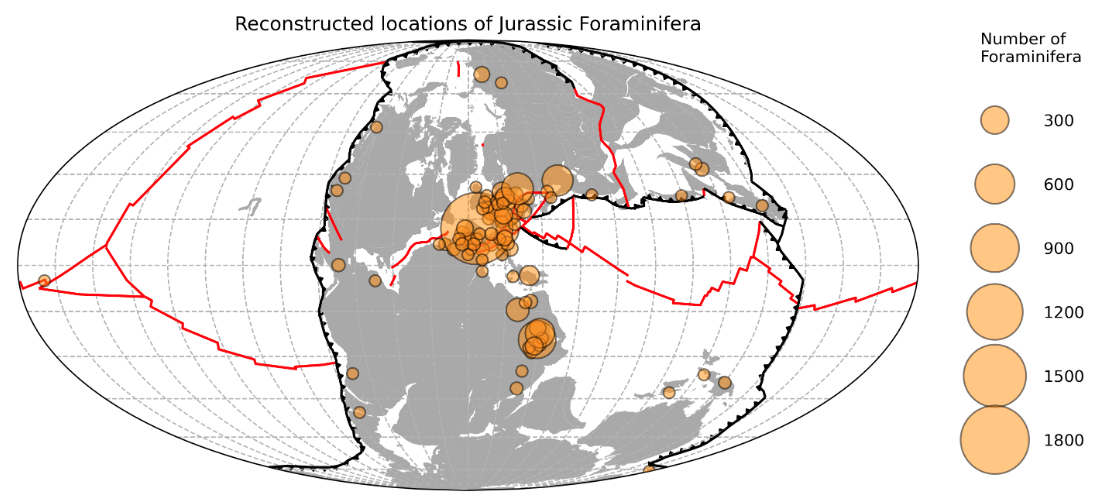
Figure 3: Reconstructed locations of Jurassic Foraminifera downloaded from the Paleobiology Database. This figure can be reproduced in Notebook 3 of the GPlately GitHub repository.
Citing GPlately + pyGPlates
Mather, B.R., Müller, R.D., Zahirovic, S., Cannon, J., Chin, M., Ilano, L., Wright, N.M., Alfonso, C., Williams, S., Tetley, M., Merdith, A. (2023) Deep time spatio-temporal data analysis using pyGPlates with PlateTectonicTools and GPlately. Geoscience Data Journal, 1–8. Available from: https://doi.org/10.1002/gdj3.185
References
Mather, B. R., Müller, R. D., Zahirovic, S., Cannon, J., Chin, M., Ilano, L., et al. (2023). Deep time spatio-temporal data analysis using pyGPlates with PlateTectonicTools and GPlately. Geoscience Data Journal. https://doi.org/10.1002/gdj3.185
Müller, R. D., Seton, M., Zahirovic, S., Williams, S. E., Matthews, K. J., Wright, N. M., et al. (2016). Ocean Basin Evolution and Global-Scale Plate Reorganization Events Since Pangea Breakup. Annual Review of Earth and Planetary Sciences, 44(1), 107–138. https://doi.org/10.1146/annurev-earth-060115-012211
Müller, R. D., Zahirovic, S., Williams, S. E., Cannon, J., Seton, M., Bower, D. J., et al. (2019). A Global Plate Model Including Lithospheric Deformation Along Major Rifts and Orogens Since the Triassic. Tectonics, 38(6), 1884–1907. https://doi.org/10.1029/2018TC005462