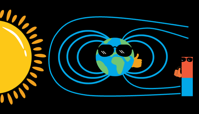
Magnets are cool, who does not like them? And the planet that we live in, the Earth, itself is a huge magnet. Not only does the Earth’s magnetic field protect us from harmful radiation from space, but it can also help us reveal some of the secrets of our planet. Local variations in the magnetic field can be used to probe the subsurface of the Earth from crustal to mantle depths. Although there is a whole suite of electromagnetic methods that can be used for this purpose, we will be discussing about “Magnetotellurics” in this post.
What is Magnetotellurics?
Magnetotellurics (abbreviated as MT) is a passive electromagnetic method, which uses the variations in the natural magnetic field caused due to electromagnetic signal sources like solar storms and lightening (Vozoff, 1991). As an area gets affected by solar flares or lightening, it produces a time-varying magnetic field. The interaction of this magnetic field with subsurface material having different resistivities induces an electric field, which can be measured with sensitive instruments (Vozoff, 1990) (Figure 1). The main goal of magnetotellurics is to measure both the magnetic and the induced electric fields and use this information to back out the resistivities below the surface. The resistivity values are directly linked to the type and properties of geological materials present in the subsurface and hence can tell us what is present beneath our feet.
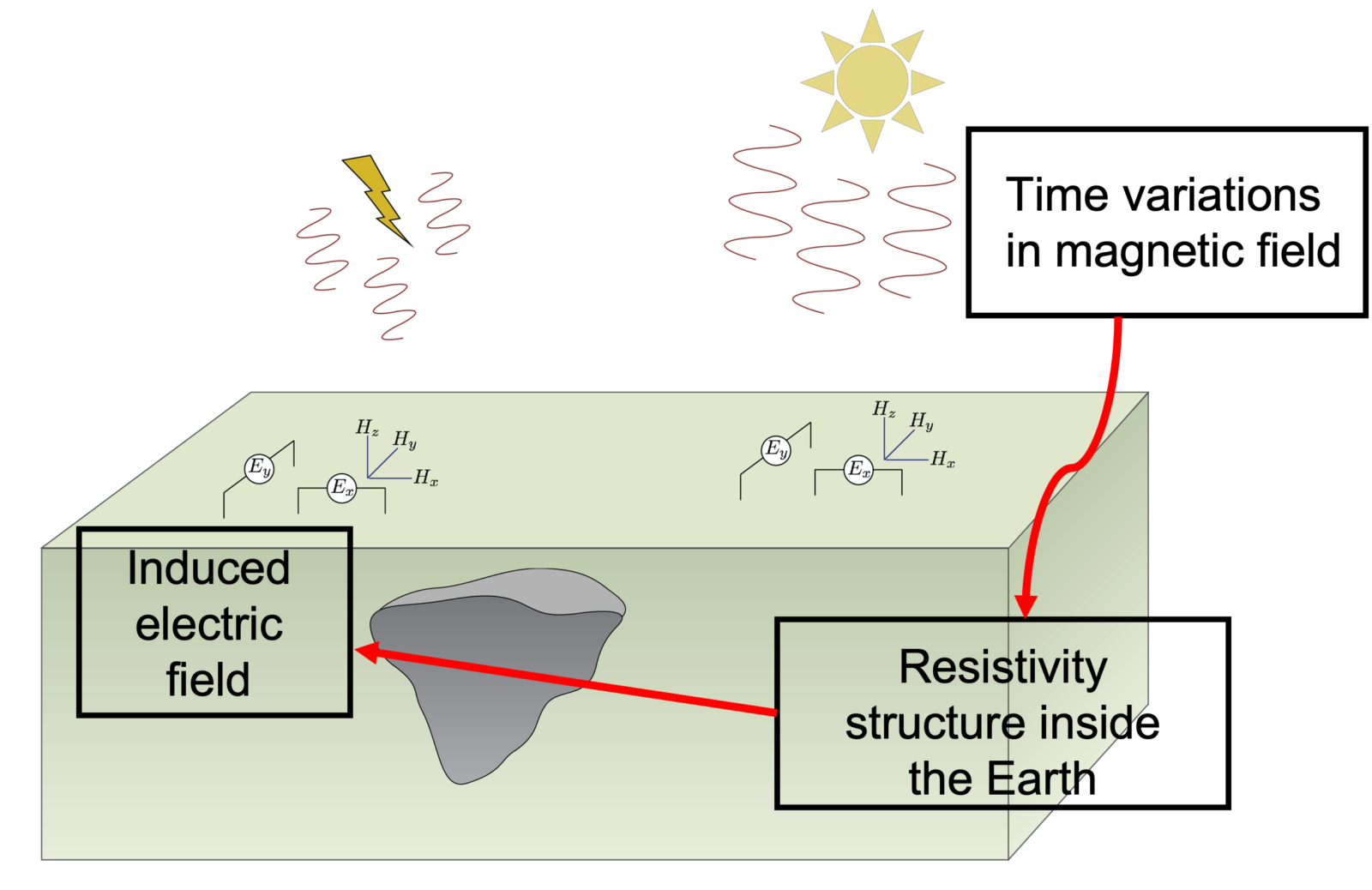
Figure 1 Principles of magnetotellurics (Image modified from Geosci.xyz)
Depth of Penetration
Magnetotelluric instruments can collect data over a wide range of frequencies, spanning from 0.001 to 10,000 Hz The depth of penetration depends on the frequency used and increases with decreasing frequency (Vozoff, 1990). This makes MT suitable for use in both near-surface exploration and much deeper studies, up to several hundred kilometres (eg. Kelbert et al., 2012; Martí et al., 2020; Bedrosian and Frost, 2022)
Station Setup
A typical magnetotelluric station in the field consists of electrodes, magnetometers, and a data acquisition unit (Figure ). Normally, there are four electrodes and two are aligned in the North-South direction and two in the East-West direction. There are three magnetometers: two of which are horizontal and oriented N-S and E-W and the third is buried vertically. This makes up the 5-component system where we obtain the values of horizontal components of the electric field (Ex and Ey), horizontal components of the magnetic field (Hx and Hy) along with the vertical component of the magnetic field (Hz).
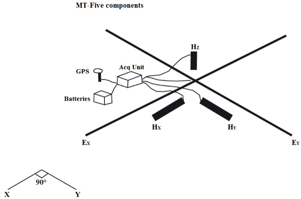
Figure 2 Magnetotelluric station set-up (Figure from Nguimbous-Kouoh et al., 2018)
Some Applications
Magnetotellurics can be applied on its own or as a complement to some other geophysical techniques. Some of the common applications of magnetotellurics include investigation of melt distribution beneath a volcano, fault characterization, mineral exploration, and exploration for geothermal energy, among others (eg. Zhang & Chouteau, 1992; Kelbert et al., 2012; Martí et al., 2020; Jiang et al., 2022). In using magnetotellurics for lithosphere-scale investigations, it has been used to study ancient rift systems and tectonic provinces (eg. Bedrosian, 2016; Bedrosian & Frost, 2022).
References:

Bedrosian, P. A. (2016). Making it and breaking it in the Midwest: Continental assembly and rifting from modeling of EarthScope magnetotelluric data. Precambrian Research, 278, 337–361. https://doi.org/10.1016/j.precamres.2016.03.009

Bedrosian, P. A., & Frost, C. D. (2022). Geophysical extent of the Wyoming Province, western USA: Insights into ancient subduction and craton stability. GSA Bulletin. https://doi.org/10.1130/B36417.1

Jiang, W., Duan, J., Doublier, M., Clark, A., Schofield, A., Brodie, R. C., & Goodwin, J. (2022). Application of multiscale magnetotelluric data to mineral exploration: An example from the east Tennant region, Northern Australia. Geophysical Journal International, 229(3), 1628–1645. https://doi.org/10.1093/gji/ggac029

Kelbert, A., Egbert, G. D., & deGroot-Hedlin, C. (2012). Crust and upper mantle electrical conductivity beneath the Yellowstone Hotspot Track. Geology, 40(5), 447–450. https://doi.org/10.1130/G32655.1

Magnetotellurics—Electromagnetic Geophysics. (n.d.). Retrieved November 23, 2022, from https://em.geosci.xyz/content/geophysical_surveys/mt/index.html

Martí, A., Queralt, P., Marcuello, A., Ledo, J., Rodríguez-Escudero, E., Martínez-Díaz, J. J., … Meqbel, N. (2020). Magnetotelluric characterization of the Alhama de Murcia Fault (Eastern Betics, Spain) and study of magnetotelluric interstation impedance inversion. Earth, Planets and Space, 72(1), 16. https://doi.org/10.1186/s40623-020-1143-2

Nguimbous-Kouoh, J., Ndougsa Mbarga, T., & Manguelle-Dicoum, E. (2018). Audio-Frequency Magnetotelluric Prospecting in the Mamfe Sedimentary Basin of Southwestern Cameroon. International Journal of Earth Science and Geophysics, 4, 1–12. https://doi.org/10.35840/2631-5033/1820

Vozoff, K. (1990). Magnetotellurics: Principles and practice. Proceedings of the Indian Academy of Sciences - Earth and Planetary Sciences, 99(4), 441–471. https://doi.org/10.1007/BF02840313

Vozoff, K. (1991). THE MAGNETOTELLURIC METHOD. In M. N. Nabighian (Ed.), Electromagnetic Methods in Applied Geophysics: Volume 2, Application, Parts A and B (Vol. 3, p. 0). Society of Exploration Geophysicists. https://doi.org/10.1190/1.9781560802686.ch8

Zhang, P., & Chouteau, M. (1992). The use of magnetotellurics for mineral exploration: An experiment in the Chibougamau region of Quebec. Canadian Journal of Earth Sciences, 29(4), 621–635. https://doi.org/10.1139/e92-054