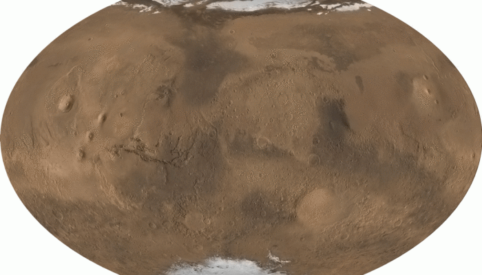
One of our closest neighbors in the universe, the red planet, has long intrigued geoscientists. Mars has been the destination for multiple spacecraft missions. Two rovers, Curiosity and Perseverance, are still exploring the planet as of 2025. This week, let us go on a short tour around Mars and show a little love to this fascinating planet.
We will start our tour by looking at the global topography of Mars. The Mars Global Surveyor provided some very compelling images of the Martian surface. These images showcase some unique topographic features of Mars, including the distinct dichotomy in the Martian topography. The Northern Hemisphere of Mars is mostly covered by low-lying plains, i.e., the Northern Lowlands, while the Southern Highlands occupy the south. Taking a closer look reveals that the Southern Highlands are more cratered than the Northern Plains, and, therefore preserve older surfaces. Based on the degree of cratering the surface has suffered, the geological history of Mars is divided into three main periods: the Noachian, the Hesperian, and the Amazonian Epochs (Carr and Head, 2010).
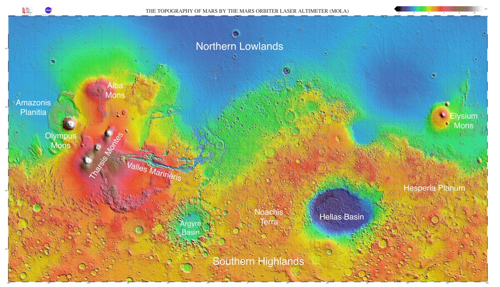
Martian topography and its major features. (Image credit: MOLA Science Team, NASA, JPL)
The Noachian terrains of Mars are heavily cratered and have newer craters superposed on older craters. The Amazonian terrains are much smoother in comparison, and the Hesperian terrains take the middle ground. Let us go around these terrains to take a look at a few interesting Martian features.
Tharsis Rise and Olympus Mons
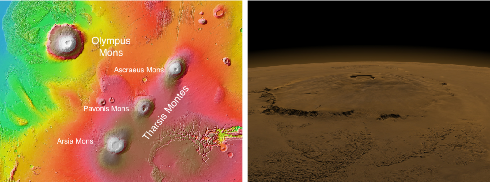
Tharsis Rise and Olympus Mons (left) (Image credit: MOLA Science Team, NASA/JPL). True color map of Olympus Mons (right) (Image credit: NASA/Goddard Space Flight Center, Scientific Visualization Studio, and Virginia Butcher (SSAI)).
The bulge near its equator is one of the most prominent features of Martian topography. Known as the Tharsis Rise, this bulge represents a volcanic province. The Tharsis Rise has multiple calderas associated with basaltic volcanism. The Tharsis Montes is a group of three shield volcanoes that are aligned in a linear fashion. To the northwest of the Tharsis Montes, Mars hosts the largest known volcano in the Solar System: Olympus Mons. Standing at ~25 km high (NASA/JPL), it is more than twice the height of the Mount Everest above sea level.
Valles Marineris
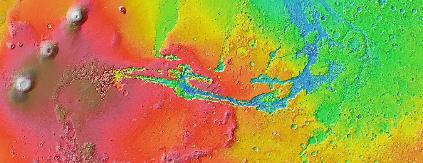
Mars Orbiter Laser Altimeter (MOLA) color map showing the canyons in Valles Marineris. (Image credit: NASA/JPL)
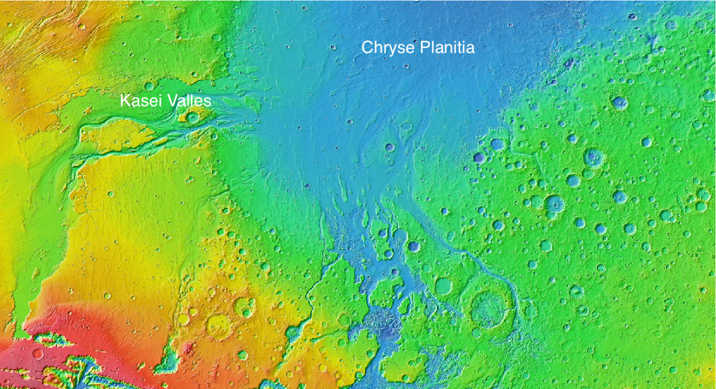
Mars Orbiter Laser Altimeter (MOLA) color map showing the outflow channels going from Valles Marineris to Chryse Planitia. (Image credit: NASA/JPL)
Just east of the Tharsis Montes, there is a canyon system: the Valles Marineris, named after the Mariner 9 spacecraft. Valles Marineris is recognized as the largest canyon in the Solar System. The formation of Valles Marineris is thought to be linked to the volcanism in the Tharsis region (Montgomery et al., 2009). Outflow channels originating from Valles Marineris go toward the Chryse Planitia to the north.
Hellas Basin/Planitia
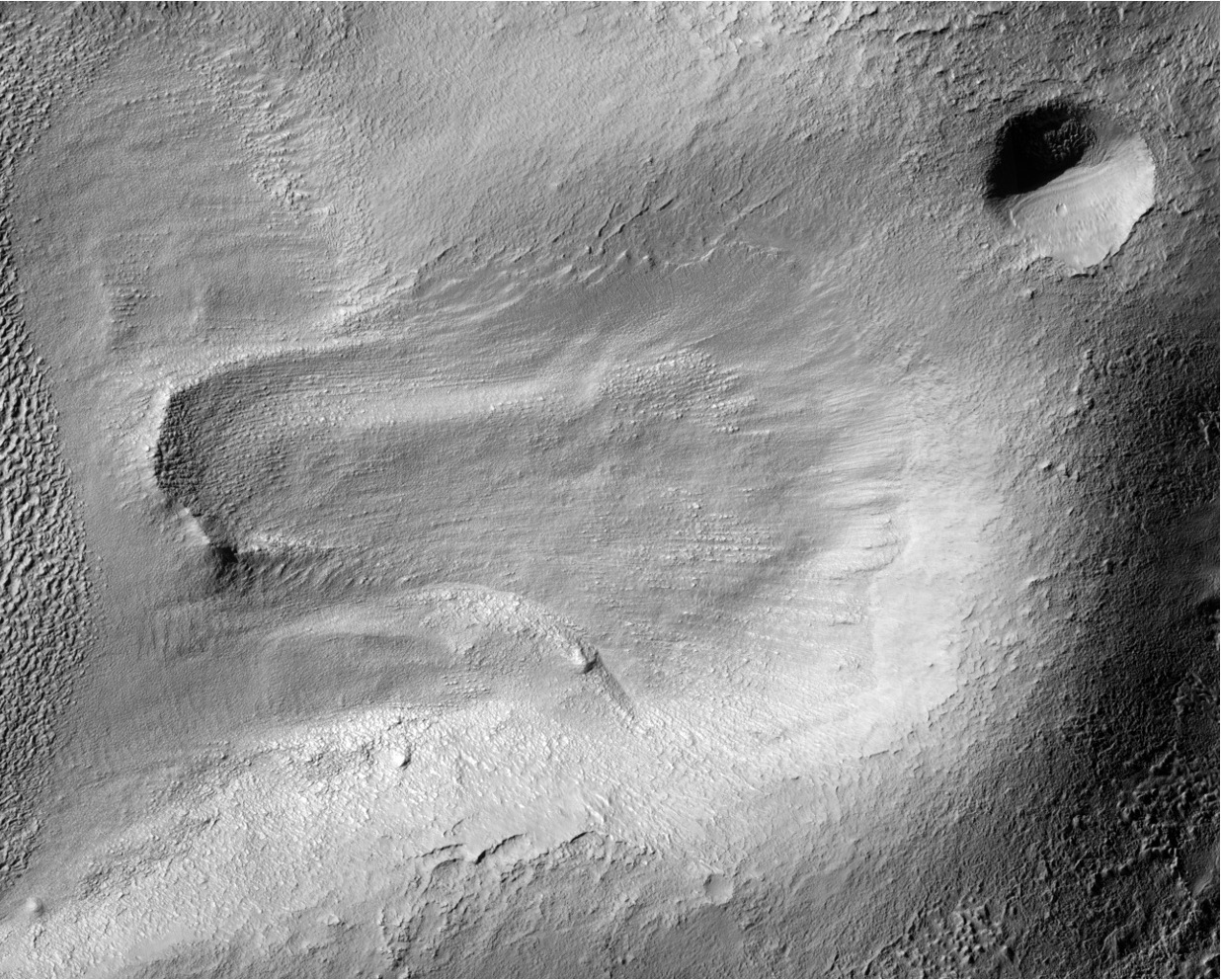
HiRISE (High Resolution Imaging Science Experiment) image showing moraine-like feature in Hellas Basin. (Image credit: NASA/JPL-Caltech/UArizona)
The Hellas Basin is a huge impact crater and features the lowest point on the surface of Mars. At 2300 km wide (NASA), it is the largest impact crater in the Solar System. The Hellas Planitia also contains landforms associated with glaciation (Grau Galofre et al., 2024) in addition to features that are associated with fluvial and aeolian processes.
Eberswalde Delta
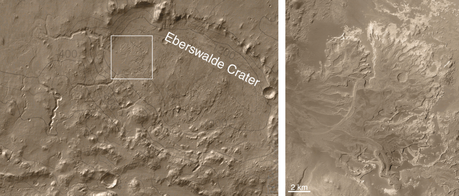
The Eberswalde crater (left) and the Eberswalde delta (right). (Image credit: NASA/JPL)
In some regions of the Noachian terrain, the crater rims look eroded and show evidence of later aqueous activity (Arvidson, 2016; Mangold et al., 2012). One such example is the Eberswalde Crater in Noachis Terra. The Eberswalde crater is a Noachian crater, located north of the much larger Holden crater. The northwest part of the Eberswalde crater has a well-preserved deltaic system, the Eberswalde Delta. The fan-shaped deposits have inverted relief and preserve sinuous channels that cut through them. This, along with the five other fluvio-deltaic systems that drain into the crater, indicate the possibility of a long-standing lake fed by persistent water inflow (Rice et al., 2013).
Although cold and dry at present, Mars is pretty fascinating in terms of its geomorphic features. And these features hold clues to deciphering the Martian geologic history, which was potentially warmer and wetter.
References
Arvidson, R. E. (2016). Aqueous history of Mars as inferred from landed mission measurements of rocks, soils, and water ice. Journal of Geophysical Research: Planets, 121(9), 1602–1626. https://doi.org/10.1002/2016JE005079

Carr, M. H., & Head, J. W. (2010). Geologic history of Mars. Earth and Planetary Science Letters, 294(3), 185–203. https://doi.org/10.1016/j.epsl.2009.06.042

Grau Galofre, A., Howard, A. D., Morgan, A. M., Wilson, S. A., & Moore, J. M. (2024). Glacial sculpting of a martian cratered landscape on the northeastern flank of the Hellas basin. Icarus, 420, 116211. https://doi.org/10.1016/j.icarus.2024.116211

Mangold, N., Kite, E. S., Kleinhans, M. G., Newsom, H., Ansan, V., Hauber, E., Kraal, E., Quantin, C., & Tanaka, K. (2012). The origin and timing of fluvial activity at Eberswalde crater, Mars. Icarus, 220(2), 530–551. https://doi.org/10.1016/j.icarus.2012.05.026

Montgomery, D. R., Som, S. M., Jackson, M. P. A., Schreiber, B. C., Gillespie, A. R., & Adams, J. B. (2009). Continental-scale salt tectonics on Mars and the origin of Valles Marineris and associated outflow channels. GSA Bulletin, 121(1–2), 117–133. https://doi.org/10.1130/B26307.1

Rice, M. S., Iii, J. F. B., Gupta, S., Warner, N. H., & Anderson, R. B. (2013). A detailed geologic characterization of Eberswalde crater, Mars.