In this new blog, Dr. Michael Pons, one of our editors-in-chief, introduce us to the geodynamic and tectonic context surrounding the formation of the Central Andes. His PhD work focussed on the different mechanisms playing a significant role in the formation of the mountain belt using advanced numerical modelling techniques.

Dr. Michaël Pons. Contact at email or follow him on twitter @MichaPons.
Mountains can form due to different processes, as so we can distinguish different types of mountain belts (Figure 1): the ones formed at divergent margins, such as in the middle of the Atlantic ocean ridge; the ones that are thermally uplifted, such as along the Ethiopian rift; the ones formed at convergent margins where plates collide with each other, such as the Tethyan belt; the Western Pacific ring that mostly corresponds to the formation of volcanic arcs; and finally the Cordilleran-type that extends from the northern hemisphere to the southern hemisphere and is a non-collisional belt resulting from the subduction of the Pacific plate under the American continents. The Andes are part of the southern branch of the Cordillera, being the second highest orogenic belt in the world, preceded only by the Himalayas. Unlike these, which were formed by the collision of India with the Eurasian plate, there has been no typical collision for at least the last 40 million years, which is about the age of the mountain belt. This raises the question of “What is the nature of the shortening in the Andes ?“. The squares you see in Figure 1 correspond to specific areas of what is called flat subduction, which I will discuss using the southernmost square as an example.
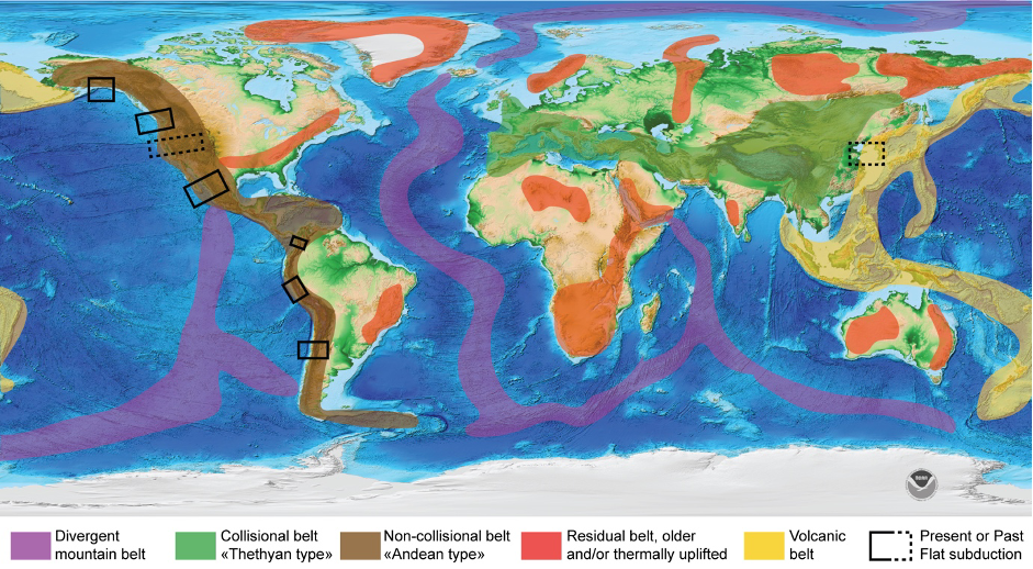
Figure 1 :Topographic map of the world (ETOPO1) showing the distribution and category of major reliefs in the worlds (From M .Pons PhD thesis).
But first let’s have a look at how the Andes are segmented (Figure 2). We can distinguish three Andean segments from north to South: a northern, a central and southern Andean segment. These segments are characterized by different elevations and shortening magnitudes of the orogen, as well as bathymetry and sediments thickness at the trench. We can distinguish the north segment from the central segment at the latitude where Nazca oceanic ridge is subducting around 15°S; and the Central segment from the Southern Andean one where the Juan Fernandez ridge subducts at 30°S. Each of the ridges are highlighted in yellow (Figure 2).
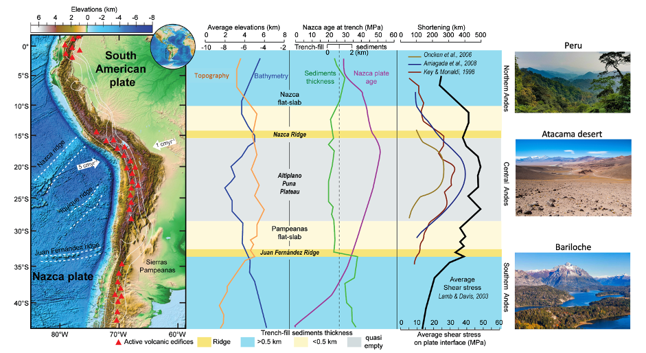
Figure 2 : Major geological features associated to the Andes from North to South (from M. Pons PhD thesis).
.
The average elevation profile shows that the highest elevation is in the Central Andes, but it is also the case for the lowest elevation, which is located at the oceanic trench, as seen by the bathymetric profile of the trench.
The oceanic plate subducting at the trench is young, around 40 Ma, slightly higher in the Central Andes. At the trench, the amount of sediments that has been eroded and transported from the mountain range is higher in the Northern and Southern Andes and lower in the Central Andes, which is dependent on the surface and climatic processes. To give you an idea, three present-day pictures are shown for different latitudes to show the variety of climates that you can find, from lush green environments to desertic areas in the Central Andes.
Previous studies have tried to quantify the amount of shortening in the Andes and evaluate the interplate coupling, showing that the shortening in the Central Andes was estimated to about ~350-400 km due to the higher interplate coupling between the Nazca oceanic plate and the South American continental plate which is inferred from the thickness of sediments bearing rich water fill-in the trench. In the Central domain the trench is “starved” and the thickness of sediments at the trench is less than 500 m.
Where the ridge subducts, you can see that the volcanic activity in red triangle is switched off, corresponding to the places where “flat subduction” is occurs.
What is a flat subduction? Where do we find them along the Central Andes?
During my PhD thesis, I became really interested in two areas in particular: the Central Andes, at Altiplano-Puna latitude, and the Southern Central Andes, where flat subduction is currently taking place.
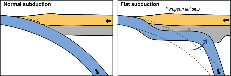
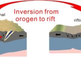
Figure 3 : Comparison between normal and flat subduction (from M. Pons thesis)
.
Flat subduction (Figure 3) can occur as a result of the subduction of oceanic ridges, usually at locations where the oceanic crust is thicker and more buoyant relative to the upper mantle. Together with other factors such as convergence speed and anchoring of the plate in the lower mantle, they favour the horizontalisation of subduction, producing the Nazca and Pampean flat slabs of today.
In the southern central Andes, where the Juan Fernandez hotspot ridge (Figure 4) is subducted under the South American continental plate. The obliquity of the convergence between the plates caused the ridge to migrate southwards relative to the margin of the continental plate, from the Altiplano latitude at 20°S at 40 Ma to the Southern Central Andes latitude 33°S today (Figure 4).
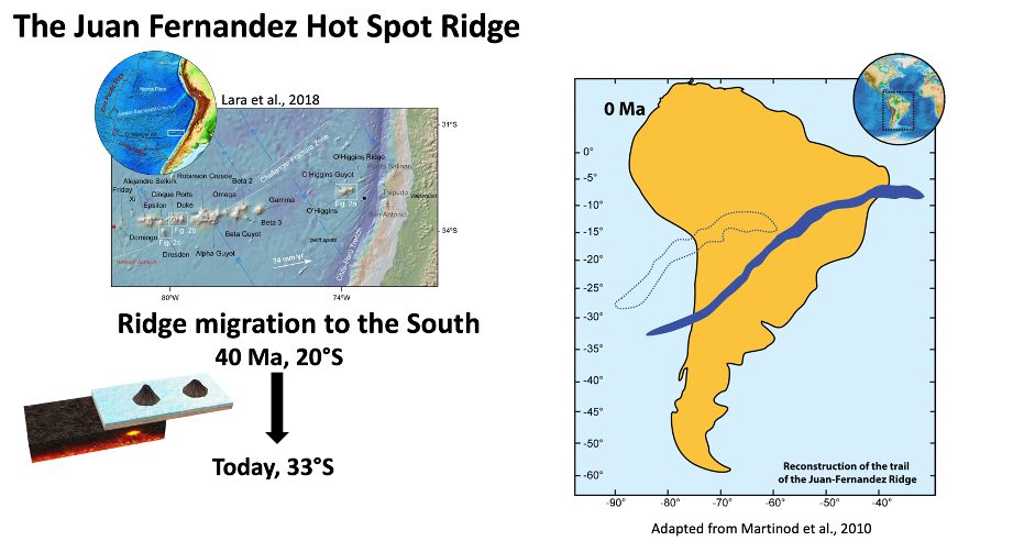
Figure 4 :The Juan Fernandez Hot Spotst Seamounts ridge structures at top left, bottom left is a sketch of how seamounts form on top of a hotspot, right is the reconstructed position of the ridge 40 My ago (dashed line) and today (filled in).
What are the Central Andes like? What are the hypotheses?
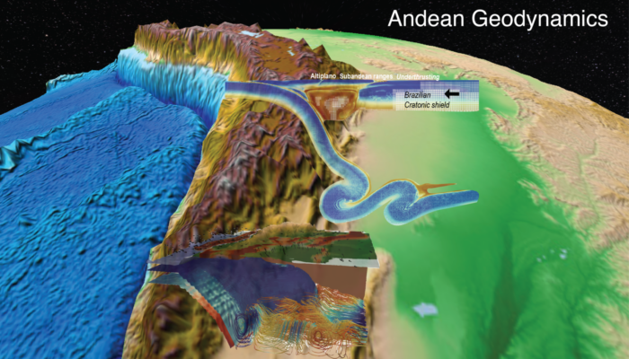
In the region of the central Andes the Nazca plate is being subducted beneath the continent (Figure 4), the average elevations of the Andes are the highest (>4km). Within the continent, we can distinguish two distinct areas, the Atliplano-Puna orogenic plateau and the Subandean Ranges foreland.
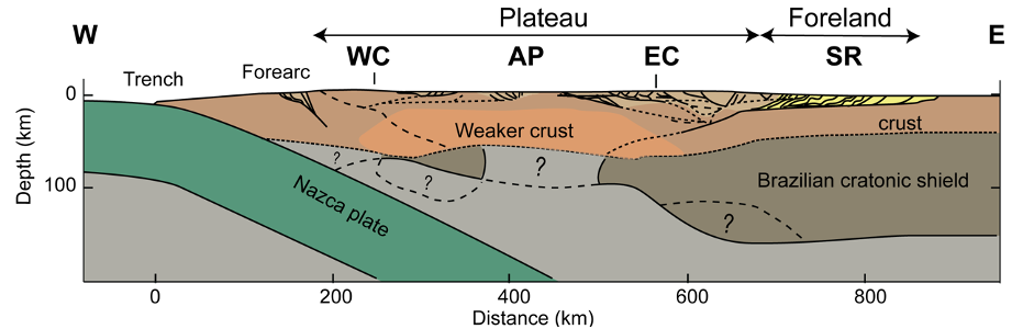
Figure 5 : Structural cross section of the Central Andes at 21°S (from Pons et al., 2022)
Most of the visible deformation (Figure 5) takes place in the Eastern Cordillera (EC) and the Subandean Ranges (SR) for this reason it is difficult to explains the average elevation of the Central Andes and the presence of an orogenic plateau from the tectonic shortening only. In addition, not so much deformation is observed at the surface of the plateau, which leads people to consider alternative hypotheses to its formation. One proposition is that due to the internal drainage of the plateau, sediments are being caught and deposited on it, therefore covering the underlying deformation so the tectonics shortening would be currently underestimated. Another explanation is coming from a notable feature in this cross section, which is the absence of sublithospheric mantle beneath the plateau, as well as the thick Brazilian cratonic lithosphere is underthrusting beneath the foreland, thus leading to the important observed deformation of the Eastern Cordillera and the Subandean Ranges. The removal of the thick and dense mantle lithosphere beneath the orogenic plateau could partially explain the current elevation of the Central Andes and also take into consideration the low deformation observed, but miss to explain the current crustal thickness of the plateau (~75km). Finally, another possible explanation could be that most of the important deformation occurs through ductile crustal flow, and the important thickening of the crust would have contributed to increasing the temperature of the crust until finally the lower crust and mantle delaminated from the increase in pressure and temperature dependent phase transition (e.g eclogitization) which induced densification.
Did the Central Andes form progressively?
From the measured and observed deformation, previous studies such as Oncken et al. (2006, 2012, Figure 6) show that the Andes as we know them today began to form around 45 Ma ago (Figure 6, top), with deformation starting in the Western Cordillera and then migrating to the Altiplano-Puna Plateau between 40 and 7 Ma ago, and finally to the Sub-Andean Ranges in the last 12 Ma. Figure 6, lower figures, shows the cumulative shortening history of the different areas from the 2006 compilation in grey and the revised 2012 version. These curves represent the rate at which the shortening occurred, or “shortening rate” which reveals that the Andes didn’t formed progressively but have known some accelerating phases, some progressive ones and some more pulsatile phases! We can see that between 45Ma and 34Ma the shortening rate accelerated steadily and further more between 34 and 30 Ma, correlating with the passage of the Juan Fernandez Ridge and the flat subduction. The shortening rate then stagnates between 30 and 15 Ma and then pulses between 15 Ma and 7 Ma and in the last 3 Ma. The last 15 Ma of deformation accounts for about 40% of the shortening of the Andes. In addition, the growth of the orogenic pleateau to its present average height takes place in the last 12 Ma. This is the time when most of the shortening comes from the Subandean Ranges.
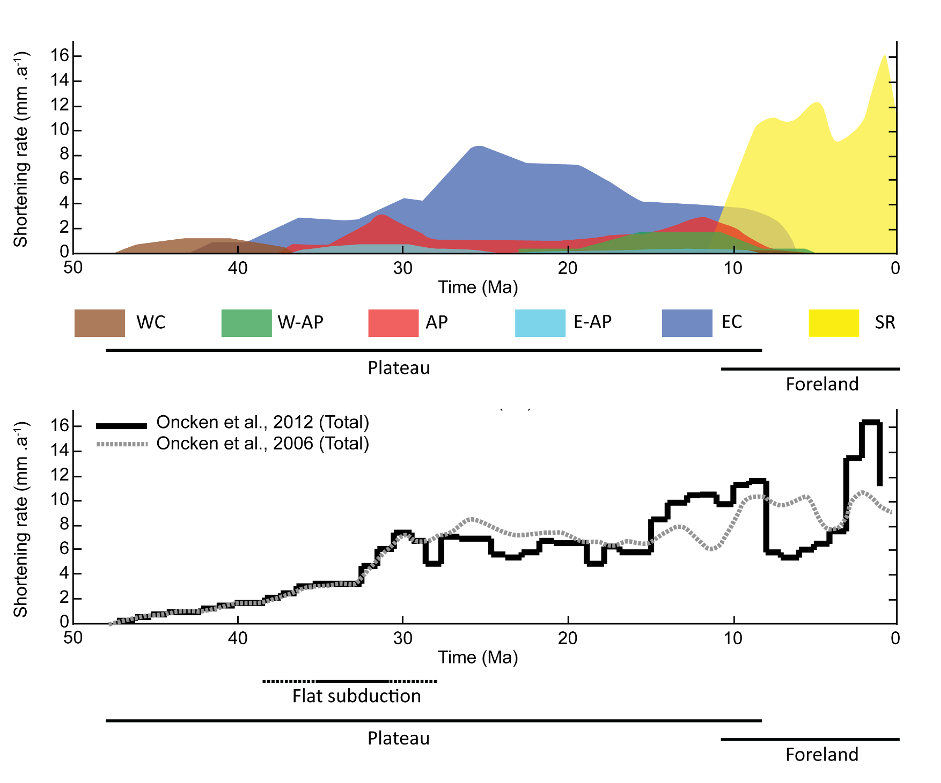
Figure 6 : On top, the shortening rate of the Andes at 21°S for different areas (modified from Oncken et al., 2006). On the bottom, the cumulated shortening rate from the compilation of 2006 in grey and 2012 in dark.
In the next part of this blog thread, we’ll look at the possible reasons for the shortening rate pulses of the last 15 Ma by using numerical geodynamic modelling of subduction zones applied to the Andes, so don’t miss out on future explanations!
Martinod, J., Husson, L., Roperch, P., Guillaume, B., & Espurt, N. (2010). Horizontal subduction zones, convergence velocity and the building of the Andes. Earth and Planetary Science Letters, 299(3-4), 299-309.

Oncken, O., Hindle, D., Kley, J., Elger, K., Victor, P., & Schemmann, K. (2006). Deformation of the central Andean upper plate system—Facts, fiction, and constraints for plateau models. The Andes: Active Subduction Orogeny, 3-27.

Oncken, O., Boutelier, D., Dresen, G., & Schemmann, K. (2012). Strain accumulation controls failure of a plate boundary zone: Linking deformation of the Central Andes and lithosphere mechanics. Geochemistry, Geophysics, Geosystems, 13(12).

Pons, M., Sobolev, S. V., Liu, S., & Neuharth, D. (2022). Hindered trench migration due to slab steepening controls the formation of the Central Andes. Journal of Geophysical Research: Solid Earth, 127(12), e2022JB025229.

Pons, M. (2023). The Nature of the tectonic shortening in Central Andes (Doctoral dissertation, Universität Potsdam).DOI : 10.25932/publishup-60089
NB: Do not hesitate to comments and let us know If you like this type of article.