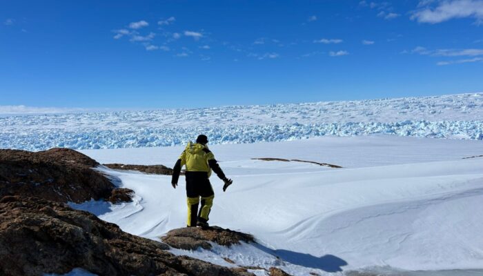
Greetings from the heart of Antarctica! This week on the EGU Geodynamics blog, we are thrilled to share an exclusive insight into the groundbreaking Denman Terrestrial Campaign. Live from the icy expanse of the white continent, a team of geophysicists—Shyla Kupis, Dr. Lu Li, Dr. Mareen Lösing, Dr. Coti Manassero, Dr. Tobias Stål, and Dr. Kate Selway—will take you on a journey through their remarkable work in mapping the elusive Denman Trough for the first time, unraveling its enigmatic history and assessing its stability..
Delving into the Denman Terrestrial Campaign
This Austral summer, we geophysicists are part of a team of 40 people working to understand the potential future sea level impact of the Denman Glacier. We are based in the Bunger Hills in East Antarctica as part of the Australian Centre for Excellence in Antarctic Science, supported by the Australian Antarctic Division.
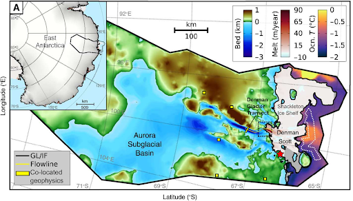
Basemap of the Denman Glacier region taken from Pelle et al. (2023), showing the grounding line (GL) and ice front (IF) of the Denman and adjacent Scott glaciers, the modelled bed topography, the satellite-inferred ice shelf basal melting rates and ocean bottom temperature. Overlain are co-located geophysical deployments currently being carried out along the Denman Glacier transect and more regional sites (yellow outlined in black). The Bunger Hills camp location is shown by the red star.
The Denman Glacier has been modelled to have the deepest inland trough on Earth, and to contain 1.5 m of global sea level potential (Morlighem et al., 2020). Its grounding line has retreated more than 5 km since 1996, motivating concerns for its stability. However, the trough of the glacier has never before been directly imaged, and its history is poorly known. How concerned should we be about the Denman Glacier? In this campaign, we are using seismic, gravity, radar and magnetotelluric (MT) measurements to image the Denman trough, the underlying hydrogeology in the ice-bedrock interface zone (IBIZ) and broader Earth-ice interactions.
A Multifaceted Approach
1. Gravity
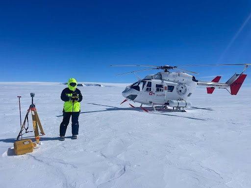
Mareen Lösing deploying GPS and gravity stations along the Denman Glacier Transect. Accessing each location by helicopter, we carefully probe for crevasses before commencing measurements.
We have taken ground-based gravity measurements along a profile across the Denman Glacier to reveal the subglacial topography and geological features and more accurately determine the Denman Glacier’s actual dimensions. We aim to investigate the symmetry of the trough’s flanks and discern the boundaries of a sedimentary basin at its western margin. While airborne gravity data is available along the same profile, terrestrial measurements offer greater sensitivity to the trough’s geometry as it is closer to the ice sheet and bed interface.
An additional goal is to image the conditions offshore of the Denman Glacier, beneath the Shackleton Ice Shelf. We are conducting a time-lapse gravity measurement over one sub-tidal cycle, which will enable us to determine density variations in both the ice shelf and the underlying ocean. This, in conjunction with seismic data, will contribute to a more comprehensive understanding of the bathymetry and composition of the bedrock beneath the ice.
2. Seismics
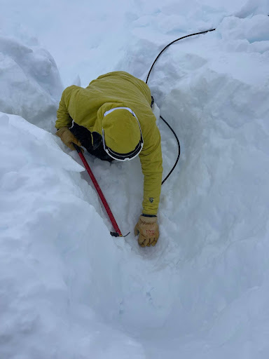
Shyla Kupis retrieving an overwinter seismometer buried under a year of snow accumulation.
We are co-locating seismometers with MT and gravimetry measurements for deployments on the Denman Glacier transect. Glacial seismicity from icequakes provides insight into glacial ice movement, aiding our understanding of subglacial basins and glaciers. In addition, long-term deployments of broadband seismic stations on outcrops near Denman Glacier will monitor seasonal variations.
Data from these installations will also be used to analyse crustal structures, with implications for glacial isostatic adjustment and subglacial geothermal heat. We are also performing reflection seismic surveys to study epishelf lake systems and shallow structures.
3. MT
We have two main goals for our MT deployments. First, we have just finished deploying instruments along the Denman Glacier, where we are collecting high-frequency data at stations co-located with the gravity and seismic measurements. These data will help constrain the thickness and shape of the Denman trough, as well as image sub-ice melt and interaction with deeper groundwater systems in the IBIZ.
Second, we are collecting long-period data at stations spread over several hundred kilometers along the coast and inland from the Denman Glacier. Combined with seismic data, we will use these data to constrain mantle viscosity and feed into models of glacial isostatic adjustment. This, in turn, will improve models of ice loss and sea level change prediction.
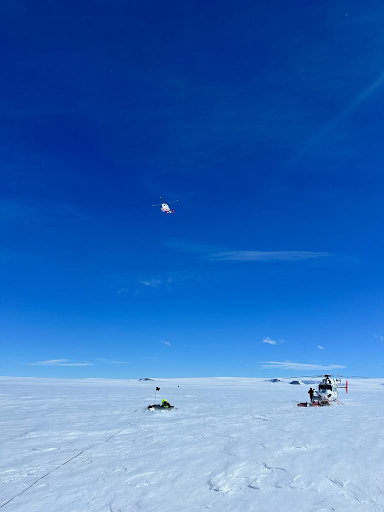
Coti Manassero and Kate Selway deploy an MT station on the Denman Glacier with Australian Antarctic Division helicopter support.
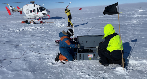
Kate Selway and Coti Manassero finish an MT deployment while Tobias Stål generates humble seismic signals for reflection seismic data
Collaborative Endeavors and Outlook
One great aspect of campaigns like this is working collaboratively in a camp full of multi-disciplinary scientists and we have been able to deploy our geophysical tools in support of several other projects. The time-lapse gravity data on the Shackleton Ice Shelf will be compared with CTD data and sediment cores that will be deployed through a hot water drill hole currently being drilled. As other colleagues conduct geological mapping and sampling, we are making magnetic susceptibility and gamma-ray intensity measurements on outcrops, which will be used to ground-truth regional geophysical interpretations and surface heat flow models. We have also carried out ground-based radar surveys to target locations suitable for ice drilling and to understand ice structure and history.
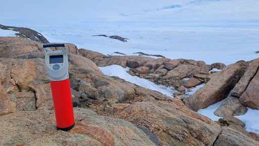
Exploring Gillies Island’s Geology: Utilizing a spectrometer to analyze gamma-ray radiation, unravelling insights into the diverse heat production of various rock types.
We have just a few weeks left of the field season, so the whole camp is starting to feel the pressure of getting projects finished. The weather is always a big factor in Antarctic fieldwork, and as we write, we are stuck in camp waiting for a storm to pass. We are hoping the weather clears soon, that we can get our final deployments done, and that our instruments will not be buried by too much snow when we get out to pick them up. Mostly, we hope that our data will provide important information on the behaviour of the Denman Glacier that you will see over the coming years.
Join us on this extraordinary journey as we unravel the secrets of Antarctica’s Denman Glacier, exploring uncharted territories and contributing to the global scientific understanding of our planet’s icy realms.
References
- Pelle, T., Greenbaum, J.S., Dow, C.F., Jenkins, A. and Morlighem, M., 2023, Subglacial discharge accelerates future retreat of Denman and Scott Glaciers, East Antarctica. Science Advances, 9, eadi9014
- Morlighem, M., Rignot, E., Binder, T., Blankenship, D., Drews, R., Eagles, G., … & Young, D. A. (2020). Deep glacial troughs and stabilizing ridges unveiled beneath the margins of the Antarctic ice sheet. Nature geoscience, 13(2), 132-137