The impact of climate change has already and will continue to cause frequent flooding episodes all over the world, with devastating consequences not only for our society but for our natural habitat as well, should we not take immediate action. Therefore, have you ever wondered, what would happen if there was an effective flood modelling system that could quickly run simulations from global datasets easily accessible to the public? Well, worry no more, because in this week’s blog Assistant Professor Bastian van den Bout from the University of Twente will introduce us to how this innovative web-based model FastFlood can actually change the narrative in flood risk management, and provide valuable resources to the scientific community as well as the general public.

Assistant Professor Bastian van den Bout from the University of Twente. You can reach Bastian via e-mail or on Linkedin.
Scientific development is often faced with the dilemma of accuracy vs applicability. Floods are no exception, and often results are needed under constraints in time (e.g., early warning or forecasting) or budget. Recently, we published our new flood methodology and launched the web-based model fastflood.org which delivers a new method and tries to find a sweet spot between accuracy and applicability (van den Bout et al., 2023).
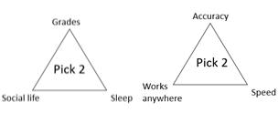
A student showed me a Pick two out of three; good grades, social life, and enough sleep. I often feel this resonate, not only in the dilemma it presents but in the field of flooding as well. It reflects a core dilemma often encountered in hazard assessment work. Accurate modelling requires detailed data about the environment and climate, and high-resolution modelling setups. These kinds of approaches are slow and often completely unusable in emergency situations. On the other hand, global datasets can be used to set up rough approximate modelling solutions, using simplified physics. The results are ready in a matter of minutes and can run in real time, but lack accuracy. Despite this, their value is unmistakably real for emergency response and early warning. Take for example the Libya disaster in 2023. Several reservoir dams were left in a critical state after a storm impacted cities like Derna. In such situations, emergency responders and disaster risk reduction managers need rapid results to make decisions about shelter locations. Unfortunately, we can often pick between two out of three; accuracy, speed and applicability.
FastFlood method
The FastFlood methodology that we developed became a major step in solving this dilemma when it comes to flood modelling. In flash, riverine or pluvial flooding, it reached 1500 times the speed with over 97% accuracy in flood extent, and 95% in flood depths (see the paper for more information).
The five steps of the algorithm are summarised below and are enabled by some efficient shortcuts in the calculation process.
- Separating the routing and pressure influences on the water distribution
- Only calculating peak flow heights
- First calculating a steady-state (faster to solve!) and compensating later
- Using directional dependencies with the Fast-Sweeping-Algorithm
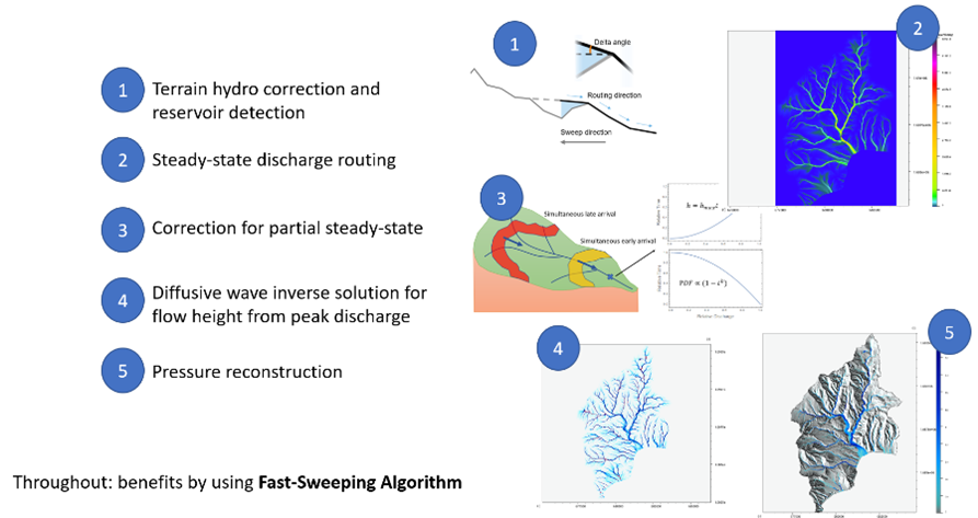
Figure 1: FastFlood methodology summarised. The method was developed mostly based on the accidental discovery of several efficient shortcuts in the computation process.
Of course, the methodology has its limitations. The assumptions that make the model so fast also mean that if these assumptions are invalid, the results suffer in accuracy. However, tests on various flood types and areas show high accuracy in many contexts. The example below shows full Saint-Venant modelling (a slower reference method) results and the results of fastflood.org side-by-side for a flash flood event in Dominica. When governments can get access to this type of information before disasters, or for a fraction of the costs, we hope to help improve disaster preparedness and risk management.
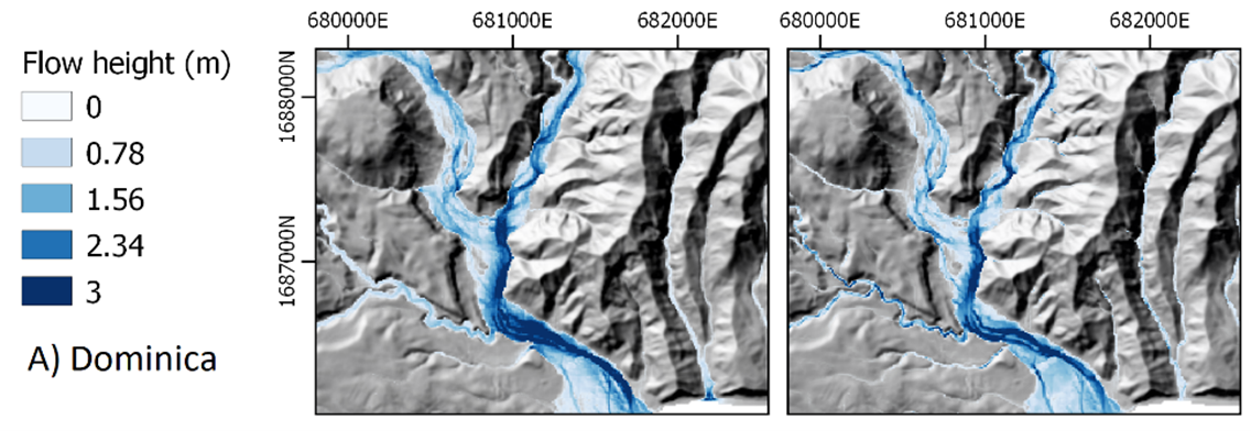
Figure 2: Full Saint-Venant simulation and FastFlood results of flash flood peak flow heights in Grande-Bay Dominica.
The website
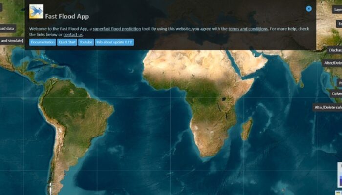
The fastflood.org web-based simulation was a way for us to bring this new technology to users around the world in the easiest way. By using some new technological frameworks, we were able to get the model running on a web platform. Web assembly allows us to get about 85% of raw C++ performance in the environment of the web browser. Additionally, this means that the computation can run on the user’s machine, whether it’s a phone, tablet, or laptop, and we don’t have to pay for server time. As a result, we can offer most of the functionality of the website for free!
Besides this, the vastness of global and satellite-based datasets on the earth’s landscape are linked for automatic usage. Think of elevation models (e.g., SRTM, Copernicus30, see Hawker et al., 2022 for some comparisons), land cover information (WorldCover10 by Copernicus, see Venter et al., 2022 for a good comparative overview) or precipitation (ECMWF Forecasts, ECMWF).
Users can go even further with tools, and implement mitigation such as levee systems, reservoirs or pumps. Land cover changes can be applied and channel information can be edited to improve your model or explore alternative scenarios. In many use cases, the model might be useful as a real-time discussion tool with stakeholders on potential mitigation. Before you run an entire DRR project, you can sketch out mitigation scenarios with municipalities and other involved parties.
Back to the dilemma
In the past year, the tool has already helped navigate the dilemma of accuracy and applicability in various types of scenarios. For the Derna disaster, we were able to supply some rapid simulations that provided a rough estimate of the flood behaviour. By using OpenStreetMaps data, we can further automatically visualise the exposure of buildings and roads.
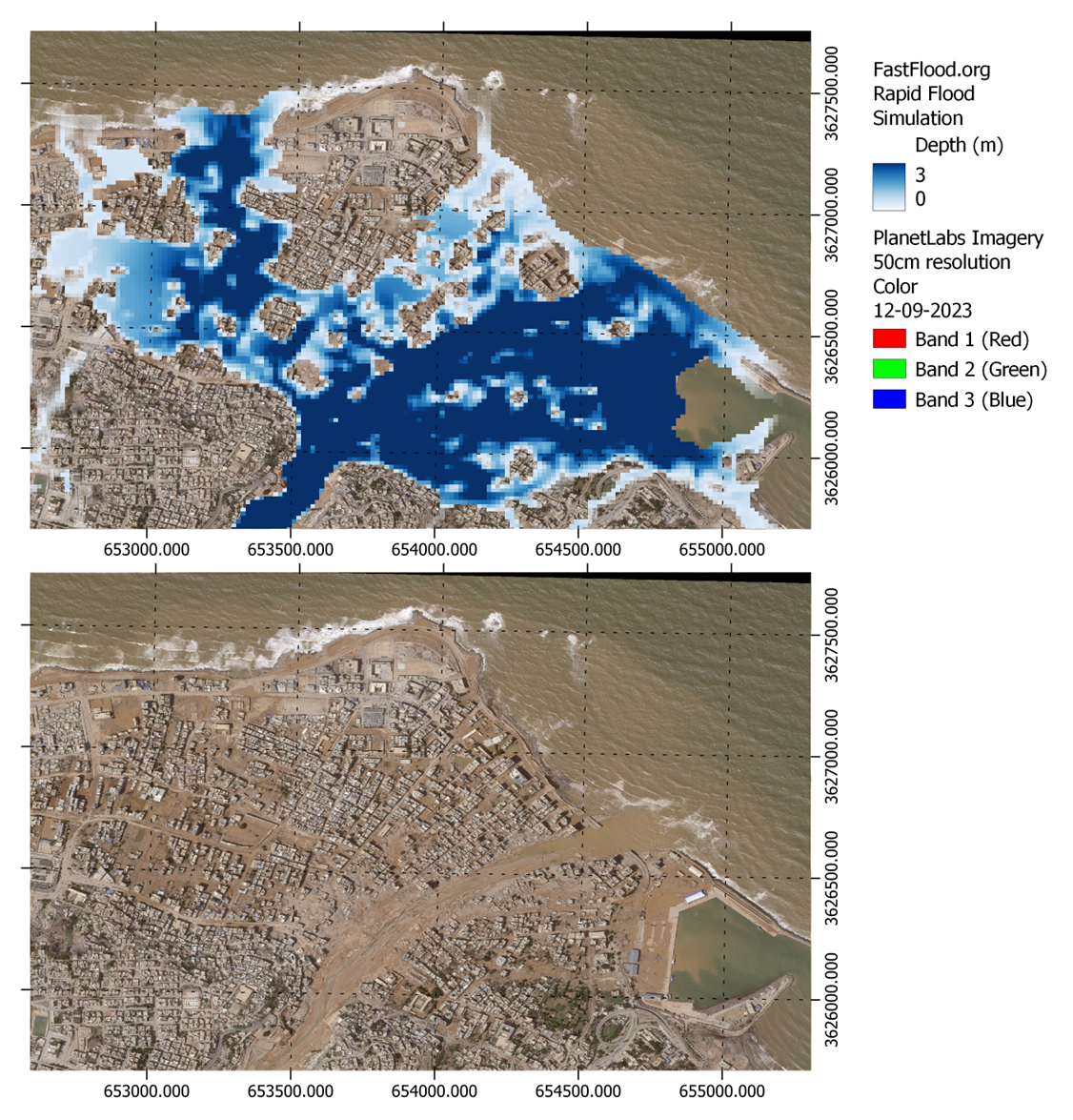
Figure 3: A rapid simulation carried out for the 2023 Derna flood disaster. In comparison, the PlanetLabs 50cm imagery is shown.
Open this simulation in FastFlood.org: Link with exposure, Link without exposure:
While the match with observations is reasonably good for a simulation that can be set up in a couple minutes and runs within a second, the real dilemma has changed. This ease of use allows for a wide, potentially untrained audience, to carry out simulations.
A new dilemma: Ease of (mis-)use
Anybody can use the tool to quickly set up flood simulations and hopefully benefit from the linked datasets to get results that are as accurate as possible. However, this also means that anybody can quickly get results that are not guaranteed to be accurate. Fastflood.org was designed to be user-friendly and help get quick results. However, it takes a trained eye to discern when the models’ assumptions are valid and when they are broken. We hope to continue addressing these going forward with:
- Tools for visualising uncertainties
- Ensemble flood simulations
- Open training materials (https://fastflood.org/site/_site/docs/home/)
- Linking calibration data
In the end, we hope people will find the tool a useful addition. We definitely have, and the development of new features will continue for years to come. If you want to run the models yourself in an operational system, please contact us and we would be happy to help you set up a custom environment for this.
 References

ECMWF, 2023. https://www.ecmwf.int/en/forecasts

Hawker, L., Uhe, P., Paulo, L., Sosa, J., Savage, J., Sampson, C., & Neal, J. (2022). A 30 m global map of elevation with forests and buildings removed. Environmental Research Letters, 17(2), 024016.

Planet, 2023. https://www.planet.com/stories/derna-libya-31-august-vs-12-september-2023-HcJzevmSg

Van den Bout, B., Jetten, V. G., van Westen, C. J., & Lombardo, L. (2023). A breakthrough in fast flood simulation. Environmental Modelling & Software, 168, 105787.

Venter, Z. S., Barton, D. N., Chakraborty, T., Simensen, T., & Singh, G. (2022). Global 10 m Land Use Land Cover Datasets: A Comparison of Dynamic World, World Cover and Esri Land Cover. Remote Sensing, 14(16), 4101.