Drawing inspiration from popular stories on our social media channels, as well as unique and quirky research news, this monthly column aims to bring you the best of the Earth and planetary sciences from around the web.
Major story and what you might have missed
This month has been an onslaught of Earth and space science news; the majority focusing on natural hazards. Hurricanes, earthquakes and volcanic eruptions have been dominating headlines, but here we also highlight some other natural disasters which have attracted far fewer reports. Quickly recap on an action-packed month with our overview, complete with links:
Hurricanes
Thought the Atlantic hurricane season is far from over, 2017 has already shattered records: since 1st June 13 storms have been named, of which seven have gone onto become hurricanes and two registered as a category 5 storm on the Saffir-Simpson Hurricane Wind Scale. In September, Hurricanes Irma, Katia and Jose batter Caribbean islands, Mexico and the Southern U.S.; hot on the heels of the hugely destructive Hurricane Harvey which made landfall in Texas and Louisiana at the end of August. Images captured by NASA’s Operational Land Imager (OLI) on the Landsat 8 satellite show the scale of the damage caused by Hurricane Irma; while photos reveal the dire situation unfolding in Puerto Rico after Hurricane Maria. OCHA, the United Nations Office for the coordinate of Human Affairs, released an infographic showing the impact the 2017 hurricane season has had on Caribbean islands (correct of 22nd September).
Earthquakes
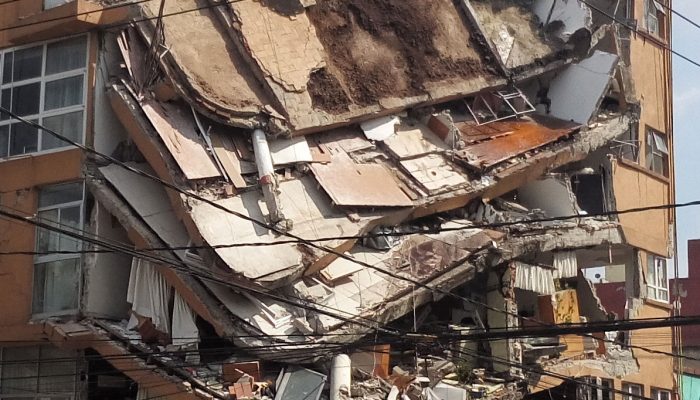
At the same time, two powerful earthquakes shook Mexico in the space of 12 days causing chaos, building collapse and hundreds of fatalities.
Rumbling volcanoes
In the meantime, all eyes on the Indonesian island of Bali have been on Mount Agung which has already forced the evacuation of almost 100,000 people as the volcano threatens to erupt for the first time in 54 years. Unprecedented seismic activity around the volcano has been increasing, though no eruptive activity has been recorded yet.
Further south, the government of Vanuatu, a South Pacific Ocean nation, declared a state of emergency and ordered the evacuation of all 11,000 residents of Ambae island, as activity of its volcano, Manaro, increased. The New Zealand Defence Force (NZDF) sent an aircraft to fly over the volcano on Tuesday and discovered plumes of smoke, ash and volcanic rocks erupting from the crater.
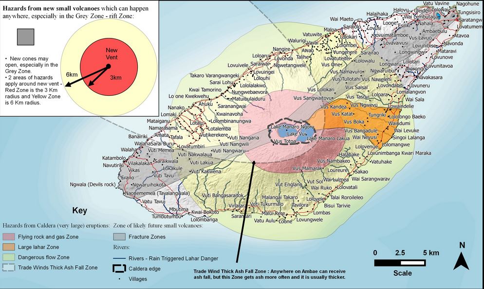
Map of volcanic hazards for Ambae in Vanuatu. Credit: Vanatu Meteorology & Geo-hazard Department (vmgd).
The rainy season floods
The summer months mark the onset of the rainy season in regions of Sub-Saharan Africa which experience a savanna climate. Across the Arabian Sea, including the Indian subcontinent and Southeast Asia, also sees the onset of the monsoon.
Since June, widespread flooding brought on by heavy rainfall has left 56 dead and more than 185,000 homeless in Niger, one of the world’s poorest countries. But the crisis is not restricted to Niger, throughout the summer floods (and associated land and mudslides) in Africa are thought to have claimed 25 times more lives than Hurricane Harvey did.
Meanwhile Mumbai struggled when the heaviest rainfall since 2005 was recorded on 29th August, with most of Northern India experiencing widespread flooding. So far, the UN estimates that 1,200 people have lost their lives across Nepal, India and Bangladesh as a result of the rains. The Red Cross estimates that at least 41 million people have been affected by the flooding and causing the onset of a humanitarian crisis.
Record breaking temperatures and fires
Australia’s record-breaking spring heat (Birdsville, in Queensland’s outback, broke a weather record as temperatures hit 42.5C and Sydney recorded its hottest ever September day) combined with an unusually dry winter means the country is bracing itself for a particularly destructive bushfire season. Already fires rage, uncontrolled (at the time of writing), in New South Wales.
The western United States and Canada suffered one of its worst wildfire seasons to date. Earlier this month, NASA released a satellite image which showed much of the region covered in smoke. High-altitude aerosols from those fires were swept up by prevailing winds and carried across the east of the continent. By 7th September the particles were detected over Ireland, the U.K and northern France, including Paris.
Europe’s forest fire has been hugely devastating too. Much of the Mediterranean and the region North of the Black Sea continues to be in high danger of forest fires following a dry and hot summer. Fires are active in the Iberian Peninsula, Greece, and Germany (among others). Over 2,000 hectares were recently scorched by wildfires in the central mountainous area of Tejeda in Gran Canaria.
Links we liked
- This month saw the end of NASA’s Cassini spacecraft and ESA’s Huygens probe’s spectacular journey to Saturn. After two decades of science, the mission ended on 15th September as the spacecraft crashed into the giant planet.
- The last day of August marks the end of the Greenland snow melt season, so September was busy for scientists evaluating how the Greenland ice sheet fared in 2017.
- “Few disciplines in today’s world play such a significant role in how society operates and what we can do to protect our future,” writes Erik Klemetti (Assoc. Prof. at Denison University), in his post on why college students should study geology.
- The BBC launched The Prequel to its much anticipated Blue Planet II, a natural history progamme about the Earth’s oceans. Narrated by Sir Sir David Attenborough, the series will featured music by Hans Zimmer and Radiohead. The trailer is a true feast for the eyes. Don’t miss it!
The EGU story
Although traditionally used to study earthquakes, like the M 8.1 earthquake in Mexico, seismometers have now become so sophisticated they are able to detect the slightest ground movements; whether they come from deep within the bowels of the planet or are triggered by events at the surface. But how, exactly, do earthquake scientists decipher the signals picked up by seismometers across the world? And more importantly, how do they know whether they are caused by an earthquake, nuclear test or a hurricane?
To find out we asked Neil Wilkins (a PhD student at the University of Bristol) and Stephen Hicks (a seismologist at the University of Southampton) to share some insights with our readers earlier on this month.

titus
very useful information
earth
Lonely Planet