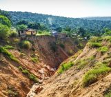
From the top of a small gully in the French Alps, a 472 kg block is launched into the chasm. Every detail of it’s trajectory down the slope is scrutinised by two cameras and a network of seismometers. They zealously record every bounce, scrape and tumble – precious data in the quest to better understand landslides.
What makes landslides tick?
In 2016, fatalities caused by landslides tipped 2,250 people. The United States Geological Survey (USGS) estimates that between 25 and 50 people are killed, annually, by landslides in the United States alone. Quantifying the economic losses caused by landslides is no easy task, but the costs are known to be of economic significance.
It is paramount that the mechanisms which govern landslides are better understood in hopes that the knowledge will lead to improved risk management in the future.
But landslides and rockfalls are rarely observed in real-time. Deciphering an event, when all you have left behind is a pile of debris, is no easy task. The next best thing (if not better than!) to witnessing a landslide (from a safe distance) is having a permanent record of its movement as it travels down a slope.
Although traditionally used to study earthquakes, seismometers have now become so sophisticated they are able to detect the slightest ground movements; whether they come from deep within the bowels of the planet or are triggered by events at the surface. For some year’s now they have been an invaluable tool in detecting mass movements (an all-encompassing term for the movement of bed rock, rock debris, soil, or mud down a slope) across the globe.
More recently, processing recorded seismic signals triggered by large catastrophic events has not only allowed to identify when and where they occurred, but also their force, how quickly they travel, gain speed and their direction of movement.
This approach gives only a limited amount of data for scientists to work with. After all, large, catastrophic, mass movements represent only a fraction of the landslide and rockfall events that occur worldwide. To gain a fuller understanding of landslide processes, information about the smaller events is needed too.
So, what if scientists could use a seismic signal which is generated by all mass movements, independent of their size?
The high-frequency seismic signal
A high-frequency seismic signal is generated as the individual particles, which combined make up a landslide or rockfall, bounce and tumble against the underlying layer of rock. Would it be possible to, retrospectively, find out information about the size and speed at which individual particles traveled from this seismic signal alone?
This very question is what took a team of scientists up into the valleys of the French Alps.
At a place where erosion carves gullies into lime-rich muds, the researchers set-up two video cameras and network of seismometers. They then launched a total of 28 blocks, of weights ranging from 76 to 472 kg, down a 200 m long gully and used the data acquired to reconstruct the precise trajectory of each block.
The impacts of each block on the underlying geology, as seen on camera, were plotted on a 3D representation of the terrain’s surface. From the time of impact, block flight time and trajectory, the team were able to find out the velocity at which the blocks travelled and the energy they carried.
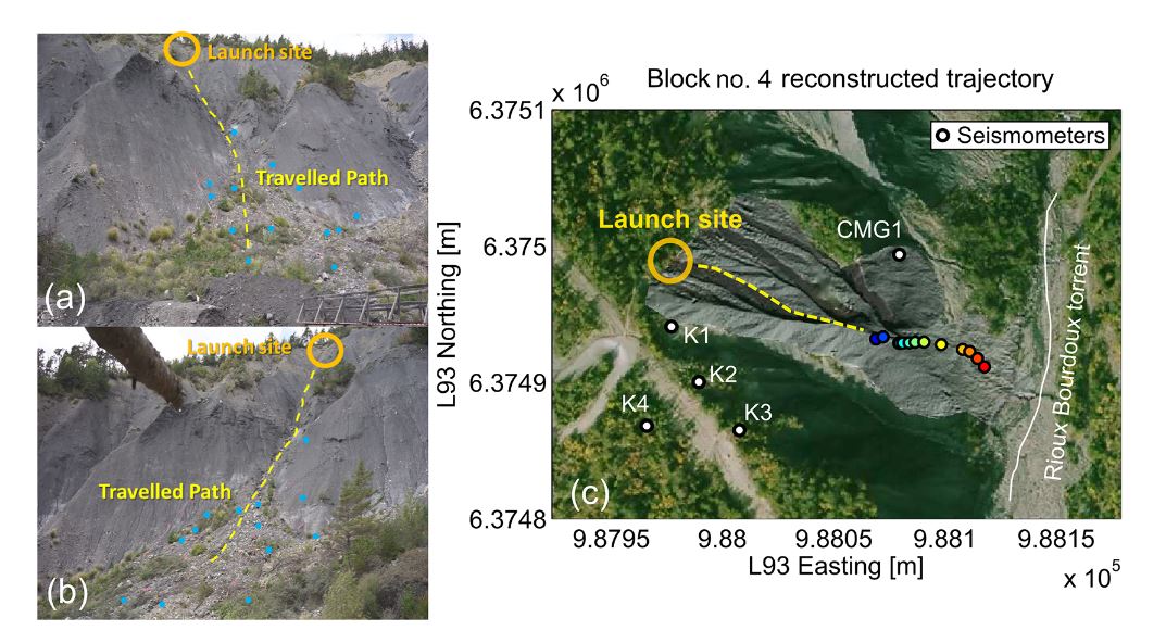
View from (a) the first and (b) the second video cameras deployed at the bottom of the slope. The ground control points are indicated by blue points. (c) Trajectory reconstruction for block 4 on the DEM, built from lidar acquisition, superimposed on an orthophoto
of the Rioux-Bourdoux slopes. Each point indicates the position of an impact and the colour gradient represents the chronology of these impacts (blue for the first impact and red for the last one). K2 is a three-component short-period seismometer and K1, K3 and K3 are vertical-only seismometers. CMG1 is a broad-band seismometer. From Hibert, C. et al., 2017. (Click to enlarge)
As each block impacted the ground, it generated a high-frequency seismic signal, which was recorded by the seismometers. The signals were processed to see if information about the (now known) properties of the blocks could be recovered.
Following a detailed analysis, the team of scientists, who recently published their results in the EGU’s open access journal Earth Surface Dynamics, found a correlation between the amplitude (the height of the wave from it’s resting position), as well as the energy of the seismic signals and the mass and velocities of the blocks before impact. This suggests that indeed, these high-frequency seismic signal can be used to find out details about rockfall and landslide dynamics.
But much work is left to be done.
There is no doubt that the type of substrate on which the particles/blocks bounce upon play a large part in governing the dynamics of mass movements. In the case of the French Alps experiment, the underlying geology of lime-rich muds was very soft and absorbed some of the energy of the impacts. Other experiments (which didn’t use single blocks), performed in hard volcanic and metamorphic rocks, found energy absorption was lessened. To really get to the bottom of how much of a role the substrate plays, single-block, controlled release experiments, like the one described in the paper, should be performed on a variety of rock types.
At the same time, while this experiment certainly highlights a link between seismic signals and individual blocks, rockfalls and landslides are made up of hundreds of thousands of particles, all of which interact with one another as they cascade down a slope. How do these complex interactions influence the seismic signals?
By Laura Roberts Artal, EGU Communications Officer
References and resources:
Hibert, C., Malet, J.-P., Bourrier, F., Provost, F., Berger, F., Bornemann, P., Tardif, P., and Mermin, E.: Single-block rockfall dynamics inferred from seismic signal analysis, Earth Surf. Dynam., 5, 283-292, doi:10.5194/esurf-5-283-2017, 2017.
USGS FAQs: How many deaths result from landslides each year?
The human cost of landslides in 2016 by David Petley, published, 30 January 2017 in The Landslide Blog, AGU Blogosphere.
[Paywalled] Klose M., Highland L., Damm B., Terhorst B.: Industrialized Countries: Challenges, Concepts, and Case Study. In: Sassa K., Canuti P., Yin Y. (eds) Landslide Science for a Safer Geoenvironment. Springer, Cham, (2014)