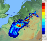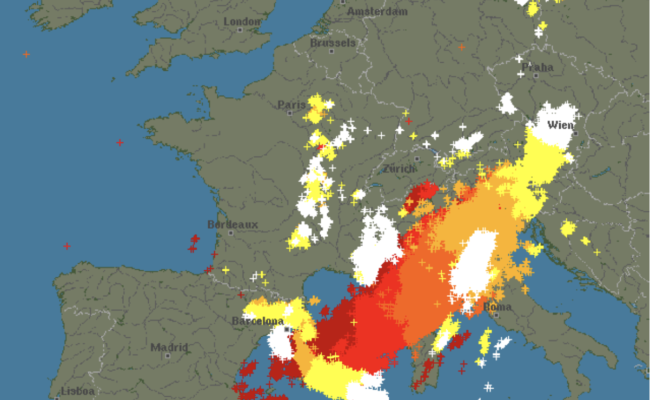
The 2022 European summer was governed by the presence of a persistent cold drop (low pressure area) located between Portugal and France. The change in its position has determined the alternation between hot conditions (low pressure center over Portugal) and stormy conditions (cold drop over France). The warming of the Mediterranean Sea (up to +6°C compared to the period 1990-2020) has largely contributed to the formation of organized convective systems. In particular, a mesoscale convective system (MCS), formed during the night of August 17 to 18 over the northern Balearic Islands, rapidly moved to the northeast, affecting Corsica early in the morning. The line of thunderstorms gradually curved and became an arc echo with the descent of the mid-level jet on the western flank of the MCS, producing strong wind gusts at the surface (>200 km/h over Corsica). The system then affected northern Italy and Austria, within 12 hours. The intensity of this phenomenon can be classified as a derecho: it is a classification of very violent storms which takes into account the gusts of wind (more than 120km/h) and the size of the affected territory (more than 300 kilometers). The derechos are phenomena that occur rather in the great plains of the United States, in flat areas with a large amount of energy available and, more rarely, over sea. In France, only the storms of July 26, 1983, July 12, 2010 and August 08, 2014 have characteristics compatible with the definition of derecho. Another important thunderstorm episode of the season hit the Paris region on August 16: a gust of 104 km/h was measured by the station located at the top of the Eiffel Tower. The rainfall (47 mm recorded at Paris-Montsouris, including 39 mm between 6 and 7 pm) caused major traffic problems and the closure of eight metro stations. On August 16, thunderstorms also hit the Bouches-du-Rhône violently, reaching and locally exceeding 100 mm: 114 mm at Saint-Sauveur-Camprieu in the Gard, 123 mm at Les Plans in the Hérault.
As stated in the latest IPCC report, summarizing the scientific literature on the link between floods and anthropogenic climate change, there is a high confidence that “a warmer climate will intensify very wet and very dry weather events and seasons, but the location and frequency of these events depend on predicted changes in regional atmospheric circulation”. Particularly for Europe, there is moderate confidence that at 1.5°C of warming, “heavy precipitation events and associated flooding are expected to intensify and become more frequent.” The 2022 thunderstorms were particularly surprising from a meteorological point of view for their extreme intensity, largely attributable to a much warmer than average Mediterranean Sea.
Indeed, Météo-France and Aeronautica Militare Italiana have been criticized for having triggered an alert only in the morning, after the first reports of wind. In fact, forecasting the organization of convection remains a challenge for meteorological models, especially when they are pushed outside their typical range of action: in this case, the weather forecast models were operating with exceptionally warm Mediterranean temperatures. We therefore expect to find this same problem of representing extreme convective phenomena in climate models that simulate the climate at a spatial resolution less fine than that of the meteorological models. There is therefore great uncertainty about the intensity that these extreme phenomena could have in an even warmer world.