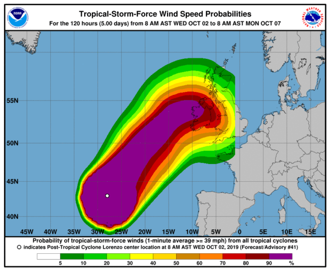
Autumn is hurricane season in the north tropics and indeed 2019 does not make exception from this point of view. After Dorian hitting Bahamas and North Carolina, the American National Hurricane Center named Lorenzo a tropical depression originating near Capo Verde. On September 25th Lorenzo became a category 1 hurricane, according to the Saffir-Simpson scale. This scale categorizes the hurricanes by their maximum sustained winds over a minute time. Lorenzo kept traveling northward and intensified to category 4 with 230 km/h winds on September 27th. Than the NHC forecasted a continuous decrease in the intensity of the hurricane caused by the cooler temperature and low heat content of the ocean at higher latitudes. However, after an initial weakening, Lorenzo gained power again become the strongest easternmost category 5 hurricane recorded in the Atlantic basin, surpassing Hugo in 1989. Travelling further northward, Lorenzo rapidly lost power and was sucked by the mid-latitude flow, transforming into an extra-tropical cyclone. Extratropical-Cyclones (commonly referred to as “storms” in English or “tempetes” in French) have completely different structures than tropical cyclones or hurricanes. They extend on a larger region and are associated to a warm and a cold front which produce respectively extended but moderate precipitations (warm front) or heavy but very localized rain showers (cold front). They can still be associated to intense winds and produce storm surge. When a hurricane such Lorenzo makes its extratropical transition near the European coasts it comes with a hybrid structure and can still be very damaging. Despite the high waves (up to 12.5 meters) and the strong winds, the damages caused by Lorenzo were minimal in Ireland, where the storm made land-fall. The effective warnings provided by the national meteorological service and based on the excellent quality of weather forecasts contributed to avoid the damages.
The question for climatologists and stakeholders is whether hurricanes could, in a future climate, reach the European coasts with a tropical structure. So far, we have only be able to observe few cases of hurricanes making their extra-tropical transition near the European coasts. As further recent examples we cite Leslie that, in 2018, almost made it to Portugal with a tropical structure and Debbie, that in 1961, made land-fall to Ireland, although the latter case is disputed due to the lack of satellite observations. Projection of changes in frequency, position and intensity of hurricanes in future climate is very difficult. The resolution of current climate models does not allow to simulate correctly the intensity of tropical cyclones. A recent ad-hoc study performed with a relatively high resolution model, suggests that future tropical cyclones wil be more prone to hit western Europe increasing the frequency and impact of hurricane force winds. This is confirmed also by theoretical arguments suggesting that the global temperature increase due to greenhouse gases emission will cause the extension of the tropical regions to higher latitudes and a larger availability of moisture. The combination of these two ingredients is key for hurricanes development. Adapting European coasts for this type of events might be necessary but very costly and challenging: hurricanes come with stronger maximum winds and heavier rainfall than the extratropical storms that these regions are used to face.
The difficulties in the forecasts and projections of future hurricanes are due to the highly non-linear behavior of these phenomena: their genesis depends on the aggregation of convective structures, their trajectory on very small variations of sea-surface temperature. The non-linear geophysics community helps forecast and projections tasks by studying the underlying convective phenomena by tracking the energy transfers in the turbulent cascades and proposing ad-hoc mathematical models.


Prof. Prem raj Pushpakaran
Prof. Prem raj Pushpakaran writes — 2022 marks the 50 years of WMO/ESCAP Panel on Tropical Cyclones and let us celebrate the occasion!!!
https://worldarchitecture.org/profiles/gfhvm/prof-prem-raj-pushpakaran-profile-page.html
villagetalkies
A great blog, it has a lot of useful information to me.
Village Talkies is a top quality professional 3D architectural walkthrough animation company in Abu Dhabi and best 3D Rendering Company in Abu Dhabi and also best 2d, 3d animation agencies in Abu Dhabi, providing Marketing & Sales videos, Safety video production, Post production and video editing services, 3D Architectural Visualization and Walkthrough Services along with luxury interior designs and exterior designs and more.