Zhurucay Ecohydrological Observatory: Critical zone observations at the top of the Andes!
A natural laboratory of tropical alpine ecohydrology
Tropical alpine ecosystems, known as the Páramo, extend to high elevations (3,000-5,000 m a.s.l.) mainly through the northern Andes of South America from Venezuela to northern Peru. Given their geographical location and elevation, Páramo areas are exposed to high energy inputs from solar radiation that can critically stress vegetation, soils, and water resources. Moreover, the highly organic nature of their soils (Andosols and peat-type Histosols) is among the unique features of the Páramo. These soils do not only act as carbon stores, but also as water reservoirs. As a result, the Páramo is considered a global sentinel of climate change and provides an extraordinary opportunity to investigate how the water-carbon-energy nexus will be affected by changes in global climate. In light of these challenges and opportunities, the Department of Water Resources and Environmental Sciences (iDRHICA) at the University of Cuenca, Ecuador, implemented and maintains the Zhurucay Ecohydrological Observatory. Research at Zhurucay aims to address the overarching question: What is the effect of global change on the ecohydrological functioning of tropical alpine ecosystems? Thus, Zhurucay has become a natural laboratory to investigate the hydrological, ecological, and geochemical processes occurring within the Páramo critical zone since its establishment in late 2010.

Photographs of the dominant organic-rich soils found at Páramo areas. Andosol (left) and Histosol (right) soils within the observatory. Photo Credit: Pablo Borja.
Where is Zhurucay located and how is it instrumented?
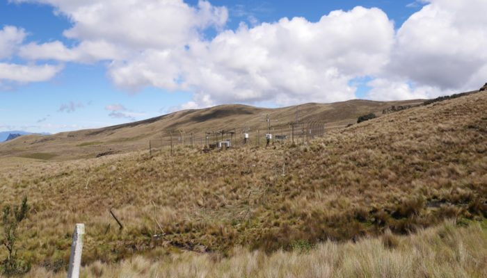
Zhurucay is located at the top of the Andes in south Ecuador, on the west slope of the divide of waters draining towards the Pacific Ocean and the Amazon basin. It extends over 3,400-3,900 m a.s.l. and its landscape is mainly composed of a series of grasslands, wetlands, small ponds, and small Polylepis forest patches
The monitoring setup at Zhurucay includes a broad range of sensors, which vary from traditional to innovative technologies. A SuperSite (3,780 m a.s.l.) is instrumented with a climate station, electronic rain gauges, a laser disdrometer, an eddy covariance tower, photosynthetic active radiation sensors, fog traps, volumetric lysimeters, and an experimental hillslope plot extensively instrumented with soil moisture probes, tensiometers, heat flux plates, and net radiometers. A network of electronic rain gauges is also distributed across the observatory. The streamflow monitoring system is composed of seven nested sub-catchments (0.2-3.3 km2) draining toward the outlet of the Zhurucay River (7.5 km2). Every catchment has probes that measure water level, water temperature, and electrical conductivity simultaneously. Additionally, one of the streamflow monitoring sites is equipped with water quality autosamplers and a UV-spectrophotometer to measure in-stream water quality parameters. An experimental forest patch micro-catchment is also equipped with point dendrometers, leaf moisture, wood moisture, sap flow, soil moisture, air humidity and temperature probes at different canopy levels and automatic throughfall collectors. All of these instruments measure and record data at five-minute intervals.

Instrumentation at Zhurucay. A) V-notch weir in one of the nested catchments of the observatory. B) Tipping bucket rain gauges of different technology and resolution and C) eddy covariance system at the SuperSite. Photo Credit: iDRHICA.

Stream water sampling for isotopic and geochemical analysis during one of the first monitoring sessions in 2011. Photo Credit: Patricio Lazo.
Complementary to these measurements, the monitoring program includes the continuous weekly to sub-daily collection of spatially distributed water samples in precipitation, streamflow, springs, and soil water for water isotope analysis since mid-2011. The isotopic monitoring scheme also includes the high-frequency (hourly to sub-hourly) collection of precipitation and streamflow water samples during rainstorm events. The continuous isotopic monitoring is complemented by campaigns of weekly to hourly collection of water samples for water quality analysis (metals and nutrients). Additional characterizations of the observatory include stream biodiversity (macro- and micro-invertebrates), the distribution and classification of soils and the sampling of soil profiles for the determination of the soils’ physical and chemical properties, and a detailed field mapping of the vegetation across the observatory.
Current understanding and open research questions
During the past five years, the analysis of field observations at Zhurucay in combination with modelling techniques has allowed for a rapid improvement in the understanding of Páramo (eco)hydrology.
- High-resolution laser disdrometer data showed that precipitation at Zhurucay occurs continuously over the year, mainly in the form of drizzle (80% of rainfall duration), with only 12% of dry days over the year.
- Isotopic and geochemical signatures were used to identify the main water sources contributing to runoff formation. These data indicate that Andean Páramo wetlands, formed by the combination of Histosol soils and cushion plant vegetation, are the main source of water contributing to discharge throughout the year despite they cover only 20% of the catchment.
- Mean transit time modelling using the isotopic signatures of precipitation and streamflow depicted that the age of streamflow varies between 2-9 months among the catchments.
- Analysis of the water storage of the catchments indicated that only 6–10% of their mixing storage is hydrologically active in their water balance.
- Mapping of the landscape features allowed to investigate whether biophysical features of the catchments influence their hydrological behavior. The runoff coefficient and the production of high and moderate flow rates of the catchments is influenced by their areal extent of wetlands; whereas their mean transit time, low flow production, and mixing storage is controlled by their topography.
- Eddy covariance analysis depicted that the Páramo is a source of CO2 and exhibits a net positive exchange. The canopy storage capacity of the dominant Páramo vegetation, tussock grass, is 2 mm; and its evapotranspiration is 51% of annual precipitation. An emulation experiment of extensive tussock grass grazing suggested that this land use practice does not alter soil moisture dynamics in the dominant Páramo soil, Andosol, as long as the soil remains undisturbed.
- The influence of streamflow dynamics on stream macro-invertebrate biodiversity showed that communities are more affected by peak flow events than low flow conditions.

Runoff originated from the Zhurucay wetlands underlain by peaty Histosol soils. This soil-ecological interaction provides the ecosystem with a high water storage capacity, while the topography of the U-shaped landscape of glacial origin controls runoff generation. Photo credit: Giovanny Mosquera.
Ongoing work at Zhurucay is aimed at addressing the following research questions:
– Which factors control precipitation formation?
– What is the role of fog and drizzle in the water balance of catchments?
– What controls the temporal variability of catchment water flow and mixing?
– What controls the dynamics of streamflow water quality parameters?
– What is the exportation of nutrients and metals via streamflow?
– What is the eco-physiological functioning of Polylepis forests?

A field visit to the Zhurucay Ecohydrological Observatory was one of the main events organized as part of the AGU Chapman Conference on “Emerging Issues in Tropical Ecohydrology” held in Cuenca, Ecuador in June, 2016. The visit attracted the interest of researchers from across the world to start cooperation with iDRHICA researchers in various fields. If you are interested, do not hesitate to contact us!
Relevance, implications, and cooperation
Runoff generated from Páramo areas supplies water and sustains the socio-economic development of millions of inhabitants in the tropical Andes. This provision of hydrological services is threatened by the ecosystem’s vulnerability to global change stressors, which occur here at faster rates than in other montane ecosystems. Thus, research at Zhurucay is targeted to develop science-based knowledge that helps improving the management of vegetation, soil, and water resources of tropical alpine ecosystems. Since acquiring such knowledge requires a holistic understanding of hydrological, ecological, and biogeochemical processes occurring at different scales in time and space, inter- and multidisciplinary research at Zhurucay is encouraged. Thus, we welcome local, national, regional, and international cooperation that helps leverage on the long-term continuous collection of hydrometric and geochemical information, which in combination with controlled experiments and the use of predictive models, is aimed at resolving the following questions from a multidisciplinary perspective:
– How do water and nutrient cycles feedback in the soil-plant-atmosphere continuum?
– How do changes in land use and climate influence the ecosystem’s water balance and nutrient cycling?
By addressing these questions, research at Zhurucay will not only contribute to fill important ecohydrological knowledge gaps at one of the most diverse, yet understudied, regions of the planet, the tropical Andes; but also to allow for the implementation of sustainable strategies that help improve the management of the Páramo natural resources. So, don’t hesitate to contact us to arrange a visit and/or start a collaboration at an alpine environment in a tropical latitude! https://www.ucuenca.edu.ec/idrhica/index.php/en/contact/
 Giovanny Mosquera is a Doctoral Researcher at the University of Cuenca, Ecuador and currently the IAHS Early Career Committee Representative for ICT, Tracers.
Edited by Matthias Sprenger and Wouter Berghuijs