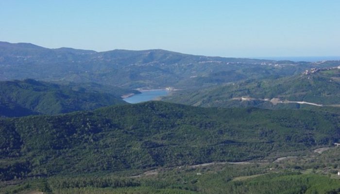
Importance of investigating water fluxes in Mediterranean catchments
MOSAIC (Modeling and Observing a mosaic of processes for Soil and water resources management in the Alento critical zone and Implementing adaptation strategies to climate and land use Changes) is an interdisciplinary research program that was established by the Soil Hydrology Group of University of Naples Federico II (Italy) and has now been operating for 18 years.
MOSAIC has become the recipient of various projects, also funded by different organizations, and its activities are essentially based on a combination of i) background studies, aiming basically to fill knowledge gaps and advance our understanding of water flow and solute transport in the soil-vegetation-atmosphere continuum, involving also soil erosion and sediment transport, ii) continuous monitoring and modeling activities, and iii) beneficial interactions with public agencies and stakeholders. These intertwining actions have produced effective outcomes for a long-term and large-scale critical zone observatory.
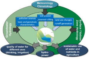
Schematic overview of our main research activities in the Alento River Catchment Hydrological Observatory.
In arid to dry sub-humid Mediterranean climate regimes, there is considerable pressure on natural water resources during the dry season when natural supply is minimal and water demand for domestic use and irrigation is at a peak. Water scarcity is a structural situation that arises when water demand exceeds water resources availability. The vulnerability of groundwater and surface freshwater resources emphasizes the need to identify the best adaptation options to avoid or at least mitigate increases in water pricing and, in worst-case scenarios, prevent water conflicts. Cost-effective adaptation options should be based on robust and reliable scenario-based projections in arid, semi-arid, and dry sub-humid regions in the Mediterranean, where water scarcity issues are well documented. However, anthropogenic disturbances such as land-use and land-cover changes rapidly affect the water cycle in a complex way. Annual rainfall is the main water supplier, yet it is hard to predict. Additionally, higher-than-normal temperatures induced by global warming are projected to affect all components of the hydrological cycle. Extreme dry (droughts, heat waves) and wet (excessive overland flow and floods) events are becoming more frequent and hold enormous risk for economic development. Moreover, they are able to generate extreme events, such as wildfires and landslides. These perturbations should be taken into due account in hydrological models and must be supported by a “smart” integration of ground-based, proximal, and remote-sensing-based earth observations. Understanding, predicting, and managing the intensification of water use and associated economic services, while mitigating and adapting to rapid climate change and biodiversity decline, is now one of the most pressing societal challenges of the 21st century. Within this context, the general purpose of the various research activities to be carried out in the Alento River Catchment Hydrological Observatory (ARC-HO) is to evaluate ecosystem services in agro-forestry environments. The ARC-HO can be considered an open-air laboratory in which to develop cutting-edge interdisciplinary collaboration among environmental, engineering, agricultural, and social sciences.
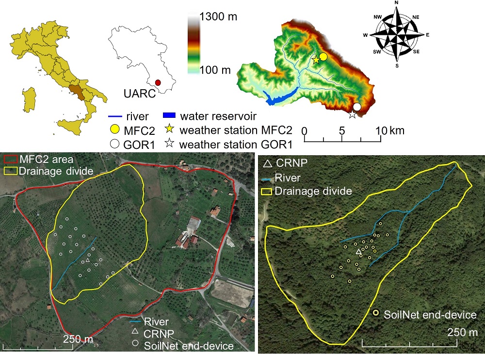
Geographical location and 5-m Digital Elevation Model (DEM) of the Upper Alento River Catchment (UARC) in Campania (southern Italy). The two experimental sites (MFC2 and GOR1) with the relevant weather stations are also shown. The artificial water reservoir is delimited by the Piano della Rocca earthen dam. The satellite images display the positions of the 20 end-devices of the SoilNet wireless network and cosmic-ray neutron probe at MFC2 (bottom-left panel) and GOR1 (bottom-right panel), respectively.
A unique hotspot in a Mediterranean ecosystem: The Alento River Catchment Hydrological Observatory
During the Roman Empire, part of the region of Campania was known as Campania Felix or “fortunate land” due to the fertility of the countryside and the abundance of its agricultural produce. On the southern side of the Sorrento Peninsula, the Amalfi Coast is probably one of Europe’s most well-known coastlines, with its towering cliffs and picturesque coves. Nevertheless, other attractions are to be found in southern Campania close to the wonderful Greek temples of Paestum and the ancient city of Elea-Velia, known as the city of the famous Greek philosophers Parmenides and Zeno. This is the renowned Cilento, featuring several World Heritage sites. Villages in both coastal and inland areas of Cilento are known for their traditional Mediterranean lifestyle, holistically termed the Mediterranean Diet (from the Ancient Greek δίαιτα, i.e. “way of living”).
The Alento River Catchment (ARC) has a drainage area of approximately 411 km2 and is situated in the middle of the Cilento National Park (the largest Italian national park), about 120 km south-east of Naples. A hydraulic system of five dams stores and supplies water for irrigation, flood control, hydropower generation, and domestic uses. The main barrage is the Piano della Rocca (PDR) earthen dam that has been operating since 1995 and can be viewed as a hinge that not only physically connects the two parts of ARC, namely the Upper ARC (UARC; 102 km2 drainage area) and Lower ARC (LARC; 309 km2 drainage area), but also embraces various monitoring and modeling activities devoted to different purposes. In UARC, the mean annual temperature is around 15.3 °C and mean annual precipitation is 1229.3 mm. In LARC, the mean annual temperature is around 16.4 °C and mean annual precipitation is 1067.1 mm.
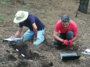
MOSAIC members reading measurements of soil moisture sensors in the field (Photo credit: Paolo Nasta).
The ARC-HO is part of the TERENO (TERrestrial Environmental Observatories) long-term ecosystem infrastructure network in Europe.
Two sub-catchments, called MFC2 and GOR1, were selected in UARC to run specific experimental studies. MFC2 is located near the village of Monteforte Cilento, on the south-facing hillslope of UARC, has a drainage area of approximately 8.0 hectares, and is representative of the cropland zone of UARC with a co-existence of relatively sparse horticultural crops, olive, walnut, and cherry trees. Instead, GOR1 is located near the village of Gorga, on the north-facing hillslope of UARC, has a drainage area of approximately 23.0 hectares, and is representative of the woodland zone of UARC, characterized by dense chestnut and oak trees with brushwood made up of ferns and brambles.
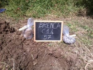
Soil pit with undisturbed (soil core sealed in the plastic bag on the left) and disturbed (soil core sealed in the plastic bag on the right) soil samples (Photo credit: Nunzio Romano).
Transect-based (at catchment scale) and grid-based (at field and sub-catchment scale) soil sampling was established to measure the basic soil physical and chemical properties (particle-size distribution, oven-dry bulk density (ρb), soil organic carbon content (SOC), pH, and CaCO3) and determine the soil water retention, θ(ψ), and hydraulic conductivity, K(ψ), characteristics.
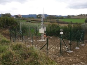
Weather station in MFC2. In 2020 we also installed a Palmex rain sampler to collect rainwater for isotopic analysis (Photo credit: Nunzio Romano).
Geological, hydrological, and vadose zone investigations started sporadically in this area at the beginning of 1990, but a more systematic research program was set up in 2003. In 2016, the MFC2 and GOR1 sub-catchments were equipped as follows:
- An automatic weather station is located near MFC2, at 400 m a.s.l., and another is near GOR1, at 711 m a.s.l. A streamflow gauging station is also located at the outlet of each sub-catchment (a water level sensor at GOR1 and an ultrasonic sensor at MFC2);
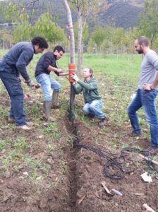
Installation of a SoilNet unit in MFC2 (Photo credit: Benedetto Sica).
- A wireless sensor network (SoilNet; Forschungszentrum Jülich, Germany), comprising 20 end-devices connected to sensors positioned at the soil depths of 0.15 m and 0.30 m. At each soil depth, the apparent soil dielectric permittivity (which is used to estimate the volumetric soil-water content, θ, through an in-situ based calibration relation), soil temperature, and soil electrical conductivity are measured by the GS3 capacitance sensors, whereas the soil matric pressure potential, ψ, is determined by the MPS-6 sensor (the GS3 and MPS-6 probes are both manufactured by METER Group, Inc., Pullman, WA, USA);
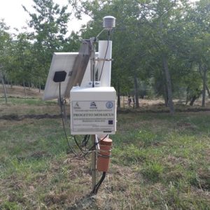
Cosmic Ray Neutron Probe in MFC2 (Photo credit: Nunzio Romano).
- A stationary cosmic-ray neutron probe (CRS2000/B by Hydroinnova LLC, Albuquerque, USA) positioned approximately at the center of the SoilNet network. The CRNP is hyper-sensitive to soil moisture within the immediate vicinity and the sensitivity to soil moisture decreases non-linearly with radial distance. The CRNP is most sensitive to soil moisture in the upper soil horizon, and this sensitivity decreases exponentially to a penetration depth of about 0.3-0.8 m depending on the soil moisture content.
Moreover, because of the presence of shallow groundwater in MFC2, 20 piezometers (consisting of PVC pipes) were also placed in this study area at depths from 6.0 m to 8.0 m below the land surface, while one piezometer was positioned at a depth of approximately 20 m. The monitoring wells are all equipped with sensors to measure the local depth to the water table. Apart from the classic chemical analyses, the water pumped from some piezometers is also used for analysis of stable isotopes (2H and 18O).
Recent measurement campaigns at MFC2 and GOR1
In 2020 we have started a research program with a transdisciplinary approach for a better description and understanding of exchange processes at the ecohydrological interfaces of this representative Mediterranean catchment. Specific interests and research questions address the effects exerted by climate seasonality, droughts, land-use changes, and soil degradation. This program is supported by the following activities:
- Sporadic measurement of the isotopic composition (2H and 18O) in groundwater, surface water, and precipitation, but also in soil and vegetation samples;
- Use of a set of innovative, non-invasive, and spatially extensive geophysical techniques;
- Harmonization of protocols for hyperspectral spaceborne (active microwave Synthetic Aperture Radars, such as Sentinel-1) and airborne (UAS) sensing both in the laboratory and in situ for mapping soil characteristics and soil moisture.
One of the main aims of this investigation is to verify the ecohydrological separation in a typical Mediterranean agro-forestry environment. The free water samples are collected in the different matrices and the bound water is extracted with the cryogenic method from both soil and vegetation samples. The experiments are carried out at the C.I.R.Ce. laboratory of the “Luigi Vanvitelli” University of Campania.
The geophysical ERT-based measurements are also scheduled on a seasonal basis at MFC2 to provide maps of soil electrical resistivity at different soil depths. Two campaigns were carried out in August and October 2020 to capture the main features of the typical Mediterranean summer and fall, whereas other campaigns are already scheduled to be carried out in the coming winter and spring.
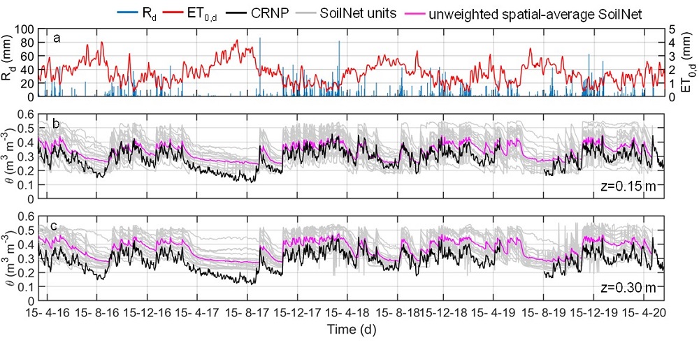
Daily values from April 2016 to May 2020 of a) rainfall, Rd (blue bars), reference evapotranspiration, ET0,d (red line), b) SoilNet-based soil moisture contents (gray lines) at 0.15 m soil depth at the 20 locations and their spatial-mean (magenta line) and CRNP-based soil moisture (black line) and c) SoilNet-based soil moisture contents (gray lines) at 0.30 m soil depth at the 20 locations and their unweighted spatial-mean (magenta line) and CRNP-based soil moisture (black line) at MFC2.
How will we be using our datasets in the future?
- Plot-scale investigations. In each of the two experimental sites of UARC, a pilot plot is identified as representative of the local environment and vegetation species. The monitored soil-vegetation-atmosphere data will be integrated with tracer measurements and then used to calibrate a 1D Richards-based hydrological model (e.g. Hydrus-1D) through an inverse modeling approach. The ad hoc calibration of key parameters controlling the main hydrological processes will provide interesting applications such as the assessment of travel time distributions from precipitation (model input) to shallow groundwater and root water uptake (model outputs).
- Field-scale investigation. MFC2 and GOR1 will be reproduced as computational grids in a 3D Richards-based model, such as HydroGeoSphere (HGS), to provide detailed, robust, and realistic simulations of hydrological processes under a data-rich situation.
- Catchment-scale investigation. The knowledge gained at the two test sub-catchments will provide lumped parameters to train semi-distributed bucket-type hydrological models, such as the Soil & Water Assessment Tool (SWAT), to simulate the main processes over the entire UARC and ARC.
Interested? Please contact us for:
- Setting up new interdisciplinary collaborations;
- Joining a new project consortium and submitting proposals to EU-funded Horizon Europe, PRIMA, or JPI calls;
- Applying for a PhD and/or a post-doc position. We are also looking for PhD students who are interested in spending short- or long-term visits;
- Scheduling a mobility period to our laboratory and the Alento River Catchment Hydrological Observatory;
- Organizing international workshops and conferences.
Author information:

Paolo Nasta is an environmental scientist at the University of Naples Federico II (Italy) with expertise in synergistic areas including soil physics and ecohydrology. His main research interests are in the application of numerical modeling of surface and subsurface flow dynamics at soil profile (HYDRUS 1D-2D, SWAP), field (HydroGeoSphere), and catchment scale (SWAT, AGWA).

Nunzio Romano is a hydraulic engineer and professor of Agricultural Hydraulics and Watershed Restoration at the University of Naples Federico II (Italy). He has expertise in soil hydrology, soil bioengineering, laboratory and field determination of soil hydraulic properties, development of simulation models for unsaturated flow, irrigation and drainage.
Edited by Giulia Zuecco

Eyal Ben Dor
great project!
Nunzio Romano
Thanks, Eyal, and now our groups will be working even more together withing the new project AGRIFAST.
Orange Didier
Wonderful ! Congratulations !
Nunzio Romano
Thanks a lot for your comment letting us know you like it.
Michele Vurro
I am very happy to see this blog. I remember the starting period. Congatulations !!
Nunzio Romano
Glad to hear you like it. Indeed, it was a really nice start and a herald of good investigations.
Yefang Jiang
Your study is very interesting. I wonder how you monitor stream water nitrate at a high frequency. I am studying the effects of implementing BMPs vs. business as usual on nitrate reduction in receiving waters in groundwater-dominated agricultural watersheds in the east coast of Canada. Linking land uses including BMPs in my watersheds is challenging due the complicated subsurface processes, diverse land uses and lack of field scale data. You are using HydroGeoSphere (HGS) to simulate flow/mass transport in field by solving 3D Richards equation. How will you couple your HGS results with SWAT?
Looking forward to readings your publications.
Best Regards
Yefang from Canada
Regards
Paolo
Dear Yefang, thank you for your interest. However, we are not monitoring water nitrate in this catchment. Nevertheless, we are simulating nitrate transport in Hydrus-1D (in a 10-m-thick soil profile beneath an irrigated corn plot) in another experimental area (Sele Plain), not so far from the Alento Observatory. We have just submitted a paper in AgWat, and we will let you know asap, thanks,
Cheers,
Paolo
Nunzio Romano
Dear Yefang, Thanks for your interest in our study.
Sampling chemicals in the streamflow is going to be done using a Teledyne-ISCO portable equipment.
As for HGS and SWAT, please consider that they have different complexities (Richards-based the former, bucket-type the latter). Therefore, a first direct option is to use them depending on the spatial scale of interest within our study area.
Paolo Nasta
Dear Yefang,
thanks for your interest in our research activity. We are not monitoring water nitrate in the Alento Hydrological Observatory. However, we are simulating nitrate transport in a 10-m-thick soil profile in another experimental site located in the Sele alluvial Plain near the city of Salerno. We use Hydrus-1D and HydroGeoSphere (in 3D).
Best regards,
Paolo
Thom Bogaard
Really nice experimental site! Good luck and I look forward to the results.
Nunzio Romano
Hi Thom, and thanks for your interest in our study.
Giuseppe Calamita
I am very glad to see in the south of Italy a great project realizing a state-of-the-art unified infrastructure like this! Congratulations!
I work very close (@CNR_IMAA, in Tito (PZ)) as an applied geophysicist, but I have a background in environmental sciences and, lately, I have been starting to think how to merge these two interests
I hope to come up with some ideas and contact you.