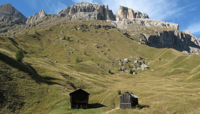
Dolomitic landscapes are characterized by vertical rock cliffs and soil-mantled hillslopes originated from glacial or colluvial deposits, which hide a complex subsurface aquifer due to the permeability of the dolomitic rocks. To improve the understanding of the hydrological functioning of such complex hydrogeological systems, the hydrology group of the Department of Land, Environment, Agriculture and Forestry of the University of Padua (Italy) equipped in 2005 an experimental high-elevation catchment, the Rio Vauz Catchment (RVC, 1.9 km2), in the Dolomites, eastern Italian Alps. The location was chosen at a site considered representative of the geology, topography, and soil characteristics of the Dolomitic area. Since then, research conducted in the RVC helped to shed new light on runoff generation processes in snow-dominated headwater catchments.
What are the main characteristics of the Rio Vauz Catchment?
The RVC has elevations ranging between 1847 m and 3152 m a.s.l.. Mean annual precipitation is 1220 mm/yr (49% falls as snow), and average monthly temperatures have a minimum of -5.7 °C in January and a maximum of 14.1 °C in July. The high elevation and the location in the central Alps determine that streamflow is mainly sustained by snowmelt and summer storm events. Land cover consists of subvertical Dolomitic rock cliffs in the upper part of the catchment, while grassland, sparse Norway spruces and European larches are typical of elevations lower than 2200 m a.s.l.. Lithology mainly consists of Triassic calcareous rocks, with stratified and deformed dolomite rocks. The complex geomorphology of the area determines the presence of two main superposed carbonate aquifers, and minor aquifers formed by scree slopes, alluvial and colluvial deposits.
Within RVC, four subcatchments were instrumented for hydrometeorological monitoring: two rocky subcatchments representative of the upper part, Channel A (ChA) and Channel B (ChB), and two subcathments in the mid-lower part covered by grassland and sparse trees, Bridge Creek Catchment (BCC) and Larch Creek Catchment (LCC). ChA, ChB and BCC have similar catchment areas (about 0.1 km2), while LCC is much smaller (0.03 km2). ChA and ChB are very steep and have <1% soil cover, while BCC and LCC are soil-mantled catchments with steep hillslopes, a distinct riparian zone and saturated areas. In the lower part of RVC, cambisols with mull are the prevailing soil types, while soil texture is dominated by clay (up to 73% in the soil profile) and has a small fraction of silt (16-28%) and sand (3-25%).
Hydrometeorological monitoring
Precipitation is measured by non-heated tipping buckets mainly from May to October at different locations with approximately one rain gauge installed per subcatchment in BCC, ChB and RVC. In addition, rainfall data are integrated with year round measurements of precipitation (by heated rain gauges) and air temperature taking place at two weather stations operated by the Agency for Environmental Protection of the Veneto Region. Water stage level is monitored by pressure transducers at BCC and ChA, while pressure transducers at the outlets of LCC, ChB and RVC were active until autumn 2013, 2016 and 2018, respectively. V-notch weirs are installed at the outlet of BCC and LCC, where water level is converted to streamflow.

The V-notch weir at the outlet of BCC. Photo credit: Giulia Zuecco.
To understand the role of topography on the spatial and temporal variability of soil moisture, measurements of soil moisture integrated over different depths were carried out daily for one month during summers 2005, 2006 and 2007 at several locations on two hillslopes at BCC and one hillslope downstream the BCC outlet. Continuous soil moisture measurements were also carried out at different locations at LCC in years 2007-2009 and at BCC in years 2005-2006 and 2010-2013 to analyze the role of soil moisture on runoff generation.
Shallow groundwater was monitored at both LCC and BCC by several piezometers installed to a depth-to-refusal. At BCC, piezometers were installed on two hillslopes in years 2008-2010 and along three transversal transects (hillslope-riparian-hillslope) in the lower part of the catchment in years 2011-2013. Data from piezometers located in the two hillslopes were used to determine the role of topography, soil depth and shape of the hillslopes in the spatio-temporal variability of shallow subsurface flow generation. Depths to water table data from LCC and the hillslope-riparian-hillslope transects in BCC were also used to quantify subsurface connectivity by a graph-theory approach and to study the effects of rainfall-runoff events and topographic characteristics on connectivity.
Starting from 2010, the hydrometric measurements were integrated with the tracer monitoring (by stable isotopes of water, 2H and 18O, electrical conductivity, and major ions) with the aim of identifying and quantifying streamflow components and inferring runoff flow paths. Samples were collected from different water sources at BCC and lower RVC (2010-ongoing), ChA, ChB and upper RVC (2011-2013). Water samples were collected from rainfall, fresh snow, snowpack, snowmelt, soil water, shallow groundwater, spring water, stream water during baseflow, and selected rainfall-runoff and snowmelt-runoff events.

Snowmelt collectors installed in BCC: a 1-m2 metallic collector box (A), and a passive capillary sampler (B). Photo credit: Giulia Zuecco and Daniele Penna.
Current understanding of hydrological processes
The experimental research activities carried out in RVC and its subcatchments have provided new insights into the hydrological functioning of Dolomitic headwater catchments. Our findings can be summarized as:
- Soil water and shallow groundwater are the dominant end members in the soil-mantled subcatchments, whereas rainfall and snowmelt play a more direct role on stream runoff and spring water in the upper rocky areas of RVC.
- There is a likely presence of a smaller and faster aquifer in the upper part of the catchment, and a deep and slow subsurface flow component in the lower part, responsible for stronger hydrochemical interactions between shallow subsurface water and soil.
- The main processes generating streamflow in the soil-mantled subcatchments of RVC, as BCC, where topography is characterized by steep slopes and a narrow riparian zone, include direct channel precipitation, saturation overland flow from the riparian zone, and shallow subsurface flow from the riparian zone and the hillslopes.
- In the lower RVC, during dry antecedent moisture conditions, shallow subsurface flow develops mainly in the riparian zone, with no or negligible response of hillslope groundwater. This results in low stormflow volumes, and small fractions of event water in the stream.
- During large rainfall events or snowmelt events at the peak melting season, overland flow develops on the entire riparian zone, resulting in higher contributions of event water to the stream compared to dry conditions. Shallow subsurface flow develops in an increasing number of riparian and hillslope locations, as shown by the activation of piezometers, and above a certain threshold a larger area of the catchment contributes to streamflow, leading to a greater runoff production.

RVC during the snowmelt period, with overland flow paths in the riparian zone of BCC. Photo credit: Daniele Penna.
Open research questions and future research
Despite the long-term observations, there are still many aspects that need to be investigated in RVC. For instance, future research should aim to comprehend:
- the controls on the high spatial variability of the tracer signature of shallow groundwater and, the role of spatially-variable shallow subsurface flow in different areas of the catchment at different temporal scales;
- the role of rain-on-snow events on the hydrological response of the catchment;
- the role of snowmelt on groundwater recharge and storage at annual time scales;
- the interplay of hydrogeological controls that determine the connectivity network, regulate water flows and link different aquifers;
- the spatial distribution of transit times and their role in governing subsurface water movements.
All these issues can be more effectively addressed by coupling experimental (e.g., by multi-tracer tests at high temporal resolution) and modelling approaches that can offer a better overview on the observed processes. This can help to unravel the intrinsic heterogeneity of Dolomitic areas, and to provide a more detailed overall perspective on the hydrological functioning of mountain headwater catchments. Furthermore, deepening our knowledge of hydrological processes in a snowmelt-dominated catchment, such as RVC, represents an important challenge in the effort of counteracting possible consequences of climate change (e.g., more frequent winter droughts) on water resources in Alpine areas.
If you got interested, do not hesitate to contact us to arrange a field visit and/or start a collaboration in a high-elevation Dolomitic catchment!

Field work during winter and summer season.