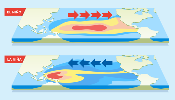
The World Meteorological Organization (WMO) has just announced that the La Niña episode has officially ended, and from autumn onwards, it should give way to an El Niño phase. But what does that mean? And what is the influence of these weather phenomena on global warming?For those who have never heard of La Niña before, here’s an explanation of this phenomenon. The Earth rotates, so there are winds, especially in the equatorial zone of the Pacific. There are trade winds blowing from east to west, from the coasts of South America toward Indonesia. This pushes the warm surface water and, as a result, causes the cold water to rise. Thus, we end up with warm water on the Indonesian side, which causes a lot of storms, and cold water on the Peruvian side, where it is dry. That is the “neutral” situation. And here’s how it can change. There are two options: El Niño or La Niña. In El Niño conditions, due to the chaos in the atmosphere, the winds are no longer pushed westward. This causes the warm water to stay in the middle of the Pacific and near the coasts of Peru, where it accumulates. Thus, there is convection and storms towards South America and fewer or no storms in the Indonesian region. La Niña, on the other hand, is the extermination of the basic circulation, so there is even more wind, the trade winds, which are pushed toward Indonesia and also push warm water. This causes even more storms in this area, and on the contrary, in South America, cold water rises from the bottom of the ocean. There are fewer storms, less precipitation, and rather dry conditions.
So, La Niña, from which we are emerging, means a lot more cold water in the equatorial Pacific zone, and El Niño means a lot more warm water. This has consequences on the global climate, as this ocean zone is quite vast. As a result, it acts as a sort of thermostat. When it’s warm, in El Niño conditions, the ocean transfers some of its heat to the atmosphere, causing the temperature to rise, and when it’s cold, La Niña cools the climate more than usual. Therefore, the World Meteorological Organization warns that the El Niño phase, which should open in a few months since it alternates, could make the situation even worse. We can expect El Niño to amplify a warm signal over the coming year if it’s a marked El Niño event.
We could start to panic after reading this, as we have just experienced the warmest years in history worldwide under La Niña, which is supposed to cool things down. So what will happen with El Niño? But, there’s no need to panic because we can very well have heat waves in the La Niña phase. The summer in Europe last year is a good example. But on the other hand, El Niño doesn’t necessarily mean that we’ll have an increased number of heat waves globally. It’s not systematic and more on a case-by-case.