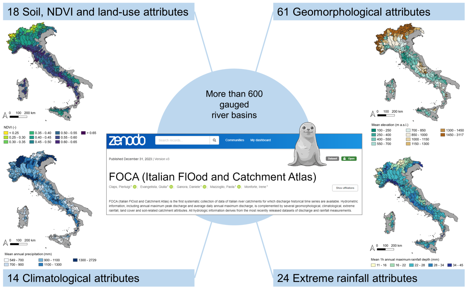
Welcome back to the HydroData Chronicles! In our previous post, we explored the innovative pRecipe package developed by Mijael Rodrigo Vargas Godoy and Yannis Markonis in 2023 and its impact on precipitation research. Today, we shift our focus to Italy with the introduction of the Italian FlOod and Catchment Atlas (FOCA) database, introduced in 2023 by Pierluigi Claps, Giulia Evangelista, Daniele Ganora, Paola Mazzoglio, and Irene Monforte. FOCA provides a complete collection of attributes for 631 gauged Italian river catchments while marking a significant milestone in the availability of hydrological data for Italy.
The Birth of FOCA
Before FOCA, hydrological data in Italy was fragmented and incomplete. Managed by 21 different regional hydrological agencies, the Italian monitoring network faced challenges in providing comprehensive data. This patchwork of information hindered national-scale research and applications. The development of FOCA represents a monumental effort to compile and standardize this fragmented data, creating a unified dataset that covers the entire country, revealing the pulse of Italian rivers and catchments.
Key Innovations of FOCA
FOCA is the first systematic collection of hydrological insights on Italian river catchments with available historical discharge time series. The main novelties of the dataset, with respect to other national-scale datasets published over other nations (like the famous CAMELS and CARAVAN), include:
- Hydrometric Information: Annual maximum peak discharge and average daily annual maximum discharge.
- Geomorphological Attributes: 61 different geomorphological attributes, offering a detailed view of the catchments. This is a significant advancement compared to datasets like CAMELS, which report only basic topographic characteristics related to outlet coordinates.
- Climatological Data: Comprehensive climatic attributes relevant to the hydrological characteristics of the catchments.
- Extreme Rainfall Features: Extreme rainfall statistics aggregated at the basin scale and at a 1 km resolution, computed using rain gauge measurements spatially interpolated with kriging, offering higher resolution and accuracy compared to coarse datasets such as ERA5.
- Land-Cover and Soil-Related Attributes: Detailed land-cover and soil data to enhance the understanding of catchment characteristics.
FOCA data collection, by Pierluigi Claps, Giulia Evangelista, Daniele Ganora, Paola Mazzoglio, and Irene Monforte (@ Authors, under the Creative Commons Attribution 4.0 License)
Ensuring Quality and Reproducibility
The FOCA dataset is built using the most recently released datasets of discharge and rainfall measurements. To enhance the reproducibility and transferability of the analysis, the FOCA team provides a detailed description of all the raw data and the algorithms used to build the basin attribute dataset. They also describe the approaches adopted to solve problems encountered during the digital elevation model elaboration in areas with complex morphology. Additionally, the data quality-control procedures developed to detect and correct errors are thoroughly reported.
FOCA in Action
Researchers, take your seats. FOCA’s stage awaits. The FOCA dataset provides a wealth of information that can be used for various hydrological analyses and applications. Researchers can utilize FOCA to study flood risks, catchment characteristics, and hydrological responses to climatic changes. With FOCA’s detailed geomorphological and rainfall data, you’ll compose hydrological sonnets, whether you’re a local troubadour or a national maestro.
Accessing FOCA
The FOCA dataset is freely available and can be accessed here. It contains all the catchment boundaries and related catchment attributes described before. In case of future updates, to access the latest version of the database, readers can refer to Claps et al., 2023, so as to download the most recent version while ensuring the advancement of their work and contributing to the collective understanding of Italy’s hydrology.
Call for Contents
As we continue our journey through the world of hydrological data, we invite fellow researchers, scientists, and enthusiasts to contribute to the HydroData Chronicles. If you have a dataset that you believe would be valuable to others in the field, we would love to feature it in an upcoming post.
Feel free to reach out to [athanseraf@hotmail.com] to discuss featuring your dataset in an upcoming post. Together, let’s delve deeper into the realm of hydrological data and uncover its untold stories.