It’s hard to overstate the importance of so-called “rainfall frequency analysis,” or the estimation of rare rainfall probabilities such as the 100-year storm. Billions of euros worth of infrastructure and planning decisions are made every year around the world based on such statistics.
Unfortunately, extreme short-duration rainfall—meaning very high rainfall rates over a few minutes to a few hours—is becoming more intense throughout the globe due to climate change. This means that existing rainfall frequency analyses are or will soon be out of date, leading to undersized infrastructure and unsafe conditions. The problem is worse in the Global South, where long records of rainfall are scarce.
Traditional rainfall frequency methods assume a “stationary” (unchanging) climate and are not up to the task in our reality of rapid climate change. Meanwhile, coarse-resolution global climate models are incapable of providing meaningful future projections of short-duration rainfall extremes. Higher-resolution models are too computationally expensive to provide information for very high-magnitude, low-probability storms.
Given this combination of great societal importance and scientific difficulty, it is fair to describe frequency analysis of short-duration rainfall in a warming climate as a grand challenge.
Recognizing Scaling Relationships
A bright spot in the science of short-duration rainfall has been the recognition of “scaling relationships”between heavy rainfall and near-surface temperature. Extreme rainfall measurements (for example, above the 99th percentile of 10-minute rainfall amounts) typically show “super-Clausius-Clapeyron scaling.” This means they increase more rapidly with temperature than the 7% per °C predicted by the well-known Clausius-Clapeyron (CC) relation, which describes how much water vapor can be contained in the air at a specific temperature.
In other words, when the atmosphere warms and the amount of water vapor increases, the resulting rainfalls can be greater—sometimes much greater—than water vapor increases alone can explain. Super-CC scaling results from invigorated storm dynamics such as stronger updrafts. Observations and simulations have shown that this super-CC scaling holds until very high air temperatures are reached, at which point extreme rainfall decreases.
Recognizing the value of this scaling relationship for rainfall frequency analysis, A recent paper by Dr. Francesco Marra and colleagues in Hydrology and Earth System Sciences introduced a temperature-dependent model for short duration rainfall frequency analysis, called TENAX: The TEmperature-dependent Non-Asymptotic statistical model for eXtreme return levels.
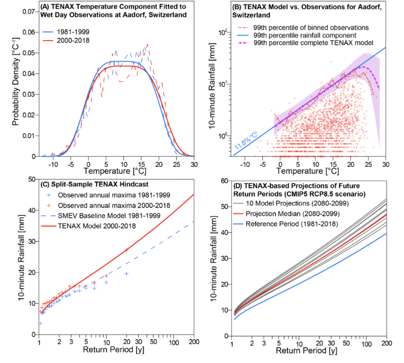
Their innovative approach combines a wet-day temperature component (Figure A) with a rainfall magnitude component (the blue line in Figure B). Using weather stations in Switzerland, the authors show that when the two components are combined, the resulting TENAX model can accurately describe super-CC scaling, including the aforementioned “hook” structure visible in Figure B at which observed rainfall rates begin to decrease at high temperatures (in this case, roughly 20-25°C) due to the very rare co-occurrence of extreme heat and rainfall.

Figure: (A) Temperature observations (dashed lines) and TENAX temperature component (solid lines) on wet days for Aadorf, Switzerland. (B) short-duration rainfall observations (red dots) on wet days for the Aadorf station, compared with the TENAX rainfall magnitude model (blue) and the complete TENAX model (pink dotted line and shading). (C) Application of TENAX to two historical periods; note that the modest shift in wet-day temperatures between these two periods in (A) results in substantial differences in rainfall probabilities in (C). (D) Application of TENAX to wet-day projections from ten end-of-century global climate model projections for the Aadorf station.
Furthermore, they show that TENAX provides comparable accuracy to more traditional extreme value methods, but requires shorter data records and offers lower uncertainty.
Predicting the Future of Sub-Hourly Storms
Perhaps more importantly, TENAX is explicitly designed to handle “nonstationary” (changing) climate conditions.
By splitting historical observations into separate periods, they were able to demonstrate a unique capability of the model, as well as an important reality. Relatively small temperature increases (Figure A) can lead to very large increases in rare rainfall events such as the 100-year 10-minute storm. TENAX predicts that the likelihood of such a storm has enhanced considerably in only 20 years for Aadorf, Switzerland (Figure C) in response to an increase in the average wet-day temperature of less than half a degree.
The authors went on to apply TENAX to additional locations in Switzerland using changes in future wet-day temperatures and their frequencies projected by a suite of ten global climate models. Compared with their inability to simulate short-duration extreme rainfall directly, global models do well at simulating the number of wet days and their associated temperatures.
Part D of the figure shows the results of this application; the 100-year 10-minute storm for Aadorf is projected to increase roughly 20% by the end of the 21st century, relative to their 1981-2018 baseline.
Projecting Sub-Hourly Rainfall Extremes Anywhere
To quote Marra et al. (2024): “With the TENAX model, one can project sub-hourly rainfall extremes at different return levels based on daily scale projections from climate models in any location globally where observations of sub-hourly rainfall data and near-surface air temperature are available.”
Their development goes a long way towards solving the grand challenge of how to provide reliable estimates of low-probability, high-impact short-duration rainstorms such as the 100-year storm.
The necessary observations are relatively plentiful in wealthy countries; an equitable global solution would require more measurements in disadvantaged communities that need climate solutions the most.
Edited by Christina Orieschnig


