Recently, an increased number of visually striking “scientific” images have been found online: snapshots of turbulent flows with dreamlike structure, eerily symmetric cloud patterns, and what appeared to be global temperature fields annotated with plausible colormaps and scientific-looking labels. Many of these posts quickly go viral on social media. And yet, in many cases, the images are not scientific at all. They are generated by artificial intelligence — and they are entirely fake.
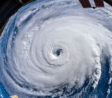
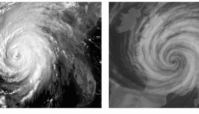
AI image generators like DALL·E, Midjourney, and Stable Diffusion are trained to reproduce visual styles based on massive datasets scraped from the web. When prompted with “scientific” terms, e.g., geopotential height, seismic waveforms, atmospheric circulation anomalies, they produce outputs that mimic the aesthetics of “real” geoscientific figures, often convincingly. We asked OpenAI to generate a fake satellite image of a tropical cyclone over France. The result looks convincing at first glance, especially in grayscale, mimicking the style of infrared satellite imagery. But it’s entirely fake: the storm is too symmetric, the textures too smooth, and the meteorological setup implausible — tropical cyclones can’t exist over continental Europe with a clear eye. These images borrow the visual language of real satellite data but lack any physical basis or connection to actual observations.
These AI-generated visuals are not always malicious. Some are made by artists or communicators experimenting with new tools. But others have started to appear in science-adjacent spaces — from low-quality climate misinformation posts to speculative illustrations used in education without proper attribution or explanation. A recent analysis warns that artificial intelligence is transforming every stage of the research process, from idea generation to publication and dissemination. The authors highlight both the opportunities for efficiency and creativity, and the ethical risks like knowledge homogenization and reduced human input. They call for a transparent, responsible partnership between researchers and AI, emphasizing deliberate and reflective engagement.
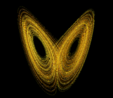
For the nonlinear geosciences community — where so much of our insight comes from visualizations of complex systems — this is a particularly urgent problem. From Hovmöller diagrams and phase space trajectories to maps of vorticity or moisture flux, our fields are not just aesthetic representations. They are evidence. An AI-generated figure that resembles a climate model output, for instance, but isn’t based on physical equations or observations, can easily mislead those unfamiliar with the difference.
One of the most subtle risks is the use of AI-generated visuals in climate misinformation. During the 2023 North Atlantic heatwave, several fake satellite images of ocean temperatures were circulated online, some using AI-enhanced artistic rendering, accompanied by misleading captions. The images were emotionally compelling — and completely detached from actual data. Without metadata, scale bars, or citations, it’s nearly impossible for a non-expert to verify the authenticity of such content.
The epistemic strength of a geophysical image comes from its connection to reproducible methods and traceable data. This is precisely what AI-generated images lack. As media theorist Johanna Drucker argued in her book Graphesis, even traditional scientific graphics carry rhetorical weight — they persuade, suggest order, and imply authority. But when visual style is uncoupled from scientific method entirely, we move from persuasion to fabrication.
So, what can we do (as scientists)?
First, it is essential that we reassert the principles of transparency and traceability in scientific communication. Every image published in a paper, on a preprint server, or shared in a scientific presentation should be accompanied by source data, description on how it has been generated or the used method, and possibly a DOI. Journals such as Nature and EGU’s own publications already have guidelines in place, but these should be adapted to also account for potential misuse of AI.
Second, we need to educate both the general public and the next generation of scientists. Many students now encounter geoscientific images on social media before they see it in a textbook or they generate through scientific data. As educators we need to teach them to read critically such images— to ask where the data come from, what processing was applied, and what assumptions were made. Resources like the Climate Visuals Toolkit or Calling Bullshit offer useful starting points for this type of education.
Finally, we might embrace AI — cautiously — in science communication and art. If clearly labeled and separated from data-driven visuals, AI tools can help us imagine what geophysical futures might look like. Projects like This Climate Does Not Exist use AI-generated imagery to provoke discussion about climate impacts in urban environments. But the boundary between speculative and scientific must always remain visible.
We are entering a new visual regime in science. As machines learn to paint like us — even to mimic the aesthetics of our discipline — we must hold fast to what distinguishes geophysical imagery from artistic rendering: not just appearance, but evidence.