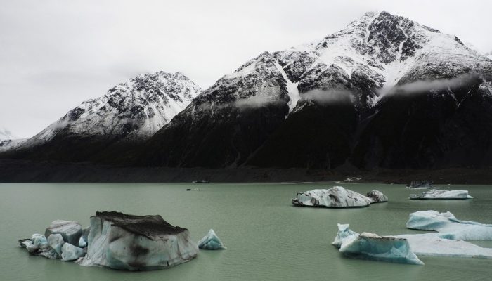
The Tasman Glacier Terminal Lake, seen in this photograph, lies in the Aoraki Mount Cook National Park in New Zealand’s south island. The photographer, Martina Ulvrova, stated she “finally got to see the largest glacier in New Zealand after several days of heavy rain, during which the landscape was bathing in mist”.
The Tasman Glacier is 23 km long and is surrounded by a terminal proglacial lake with floating icebergs. The lake was only formed in the 1970s by the melting of the Tasman Glacier. Today the lake is 7 km long and growing faster than ever with its length that is increasing by approximately 180 m per year on average!
This continual lake growth is largely due to the receding glacier which has been retreating since the 1970s and has shrunk by approximately 6 km over the past fifty years. Blocks of ice regularly break-off the flowing glacier and float peacefully on the lake. One can see only the tips of these enormous icebergs with about 90% of the iceberg mass hidden below the surface of the water.
In 2011, after a 6.3 magnitude earthquake, 40 million tonne chunk of ice broke away from the Tasman glacier and plunged into the lake. The collapse of the gigantic block caused a local tsunami with waves as high as three meters bouncing from side to side across the lake for thirty minutes. Scientists expect the Tasman glacier to continue shrinking considerably and warn that it is likely to eventually disappear. Global warming has hit this secret paradise and predictions are alarming.
If you pre-register for the 2018 General Assembly (Vienna, 08–13 April), you can take part in our annual photo competition! From 15 January until 15 February, every participant pre-registered for the General Assembly can submit up three original photos and one moving image related to the Earth, planetary, and space sciences in competition for free registration to next year’s General Assembly! These can include fantastic field photos, a stunning shot of your favourite thin section, what you’ve captured out on holiday or under the electron microscope – if it’s geoscientific, it fits the bill. Find out more about how to take part at http://imaggeo.egu.eu/photo-contest/information/.
Imaggeo is the EGU’s online open access geosciences image repository. All geoscientists (and others) can submittheir photographs and videos to this repository and, since it is open access, these images can be used for free by scientists for their presentations or publications, by educators and the general public, and some images can even be used freely for commercial purposes. Photographers also retain full rights of use, as Imaggeo images are licensed and distributed by the EGU under a Creative Commons licence. Submit your photos at http://imaggeo.egu.eu/upload/.