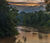
The Gunung Mulu National Park is an area so geologically remarkable and home to such incredibly diverse fauna and flora it has been declared a World Heritage Area. Located on the island of Borneo, the park is famous for its over 100 different palm species and 3500 other plant types. Geologically speaking, a trip though the varied landscapes will be rewarded with views of deep gorges and hidden valleys, as well as towering limestone and sandstone pinnacles. The predominantly calcareous landscape means most make the journey to remote area to catch a glimpse of the world’s second largest cave chamber. With dimensions of 600 m by 415 m and 80 m high, Sarawak Chamber is a natural wonder worthy of making the journey to Borneo for!
“The picture was taken in February 2014 while I was on a two month trip to Indonesia and Malaysia after graduating from my Master studies. Eventually I found one of the most beautiful places on the island of Borneo: the Gunung Mulu National Park,” explains Juliane Krenz, a PhD candidate at the Department of Environmental Science of the University of Basel.
Aside from the staggering Sarawak Chamber, the national park is crisscrossed by at least 295 km of explored caves. Made up of the Mulu Sandstone Formation, overlain by the Melinau Formation – which formed in coral rich lagoons some 20 million years ago – the caves are home to a host of species, from bats to swiftlets.
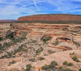
“After spending a few days exploring one of the largest cave systems in the world, I wanted to get deeper into the rainforest and climb Mount Api to see the so-called “pinnacles” – an incredible limestone karst formation everybody was talking about,” Juliane says.
The journey to reach the “pinnacles” involved an hour’s boat ride and three hours walk through the rainforest, eventually reaching a small base camp impressive for its setting: three houses next to a crystal clear stream surrounded by mountains covered in dense forest.
The hike to the sandstone spires began in earnest the next morning. To reach the impressive formations Juliane had to climb an endless number of natural steps made of slippery roots and stones of varying heights from a comfortable 20cm up to 1m, with a total elevation increase of 1200 m in little over 2km – turning the hike into an adventurous climbing trip.
“After 3 hours hiking mostly vertically we reached the top and looked down on an innumerable amount of silver-greyish rock pinnacles spiking out between the dense bright green forest, some of them being up to 40m tall. None of us would have guessed that there were so many,” describes Juliane.
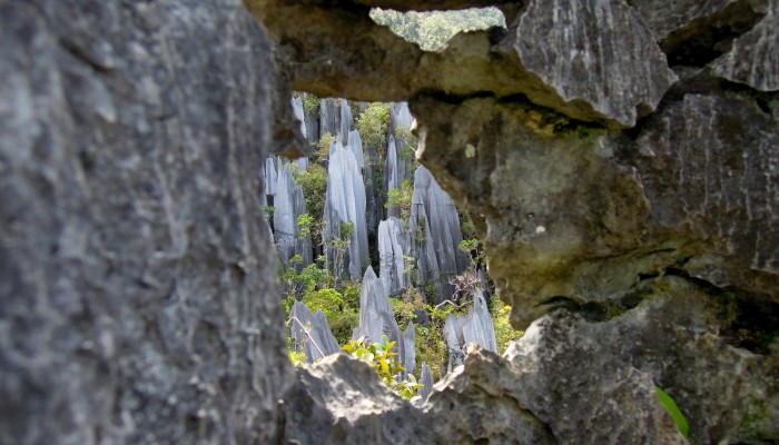
Capturing the beauty of the setting was no easy task.
“I had seen many impressive photographs of the spikes but I was looking for the special focus. Eventually I chose the hole as a frame making the largest pinnacles look like they are part of a miniature world – like me wandering through the rain forest.”
By Laura Roberts Artal , EGU Communications Officer and Juliane Krenz, a PhD candidate at the Department of Environmental Science of the University of Basel.
For more information on the Gunung National Park:
In 1977-78 there was a large expedition (followed by many others known as the Mulu Cave project) founded by the Royal Geograpical Society to explore the dimensions of the cave system. The “pinnacles” at Mount Api are part of the limestone ridge between North Thailand and New Guinea. The area is full of limestone spikes of various sizes (from few centimeters up to several meters) that are formed through weathering and dissolution over centuries. Nowadays, most research is focused on the ecology and biodiversity in the caves and the surrounding areas.
An earlier version of this post stated Sarawak Chamber was the largest cave chamber in the world. That accolade goes to Hang Sơn Đoòng in Vietnam. With thanks to @TerjeSolbakk for helping us improve this post.
Imaggeo is the EGU’s online open access geosciences image repository. All geoscientists (and others) can submit their photographs and videos to this repository and, since it is open access, these images can be used for free by scientists for their presentations or publications, by educators and the general public, and some images can even be used freely for commercial purposes. Photographers also retain full rights of use, as Imaggeo images are licensed and distributed by the EGU under a Creative Commons licence. Submit your photos at http://imaggeo.egu.eu/upload/.