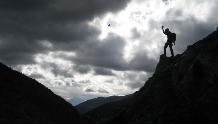
The picture was taken at a hillslope close to the glacier tongue of the Great Aletsch Glacier, the largest glacier in the Alps. With a length of 23 km it is located in the eastern Bernese Alps of Switzerland and composed of the three smaller glaciers Aletschfirn, Jungfraufirn and Eternal snow field converging at Concordia where the ice thickness was measured to be around 900m. The whole area was declared a UNESCO World Heritage site in 2001.
Alpine slopes in the region have been exposed to cycles of glacial erosion and retreat and have responded to changing slope geometry and changing stress conditions. This may have induced fracturing of the rock faces, which in turn, can be the cause of slow moving landslides and more catastrophic rock-face collapse events.
The group of engineering geology of Prof. Dr. Simon Loew of ETH Zurich is conducting research just around the strongly retreating glacier tongue of the Great Aletsch Glacier (more than 30 m length change in 2014). Together with geodesists (i.a. Stefan Conzett in the picture) extensive field work has been carried out, from 2013 to 2015, around the surroundings of the glacier tongue. This project has two main goals: (1) monitor and analyze recent rock slope instabilities surrounding the glacier tongue and currently showing movements of up to 4 cm / hour and (2) monitor cyclic deformation of the valley slopes caused by changing groundwater level, changing temperatures and glacial meltwater variations in the ice next to the slope.
Today’s image was taken by Franziska Glueer, a PhD student at ETH Zürich, during the installation of reflector prisms (which allows for the accurate calculation of position) in the steep rock walls which will be precisely measured by a total station.
The whole monitoring setup consists of 2 total stations (which send out a beam to the reflector prisms, allowing the measurement of distance, horizontal and vertical angle) on each side of the glacier, with more than 70 reflectors being monitored hourly, several permanent gps-stations taking constantly positioning data and meteo-sensors, which keep track of changing temperature and weather conditions, registering data every 30 min.
By Franziska Glueer, a PhD student at ETH Zürich
Imaggeo is the EGU’s online open access geosciences image repository. All geoscientists (and others) can submit their photographs and videos to this repository and, since it is open access, these images can be used for free by scientists for their presentations or publications, by educators and the general public, and some images can even be used freely for commercial purposes. Photographers also retain full rights of use, as Imaggeo images are licensed and distributed by the EGU under a Creative Commons licence. Submit your photos at http://imaggeo.egu.eu/upload/.


