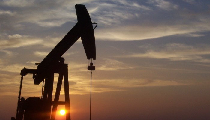
An ever growing population means the requirement for resources to fuel our modern lifestyles grows too. Be it in mining, oil/gas extraction or the improvement of renewable technologies, the boundaries of where and how we access resources are constantly being pushed. Previously inaccessible resources become viable prospects as demand increases and our technological know-how advances.
Hand in hand with technological advances, comes an increased awareness of the environment and how it may be affected by the new practices. While the need for more energy is clear, more and more, energy consumers want to understand the impacts of sourcing the energy in the first place. For instance, how seismicity is linked to the extraction of natural resources, namely gas and oil, has become an area of intense research, as well as of media, political and societal focus.
Fracking – the process by which a high pressure mixture of water, sand and chemicals is injected into reservoirs of low porosity and permeability to encourage natural gas trapped within the rock to flow to the surface – makes regular headlines. The debate as to what extent hydraulic fracturing (the formal name for fracking) of rocks, and the subsequent disposal wastewater generated as a by-product, might induce earthquakes is ongoing.
Now, let’s flip the problem, to one which is little studied and even less well understood. What are the risk associated with exploiting conventional oil and gas reservoirs in areas which are earthquake prone? This is exactly the question asked in a recently published paper by Mucciarellie, Dona and Valensise, in the open access journal, Natural Hazards and Earth System Science.
A case study: The Po Plain
In order to explore the problem, the researchers focused on the Po Plain, an alluvial plain which extends for some 45 000 km² (an area roughly half the size of Portugal), over northern Italy. It sits at the foothills of the southern Alps and is bound by the Northern Apennines to the south.
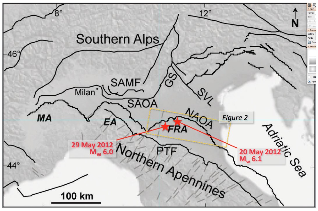
Simplified sketch of northern Italy, centred on the Po Plain and showing the southern Alps and Northern Apennines fold and thrust belts. The location of the largest shocks of the May 2012 Emilia earthquake sequence is shown with red stars. The yellow rectangle outlines the study area Key: SAMF: southern Alps mountain front; SAOA: southern Alps outer arc; GS: Giudicarier system; SVL: Schio-Vicenza line; NAOA: Northern Apennines outer arcs; PTF: pede-Apennines thrust front; MA: Monferrato arc; EA: Emilia arc; FRA: Ferrara-Romagna arc. Modified from Vannoli et al. (2015). Taken from Mucciarelli et al. (2015). Click to enlarge.
Since the 1950s the Po Plain has been systematically exploited for gas and oil. Its structural make-up is similar to many other oil and gas fields world-wide: the reservoir is hosted by growing anticlines (a type of fold which forms an ‘A’ shape) which extend to depths which are seismogenically active. It makes for an ideal case study.
The plain obscures two fold and thrusts belts, – areas of deformed sedimentary rock in which the layers are folded and duplicated by thrust faults – formed due to the proximity to the large orogens. The belts are still contracting, as the European and Adriatic plates continue to collide into one another. The contraction is accommodated by a number of faults in the area which have the potential to generate M 5.5+ earthquakes.
Indeed, the Po Plain was hit by a series of earthquakes and aftershocks in May and June 2012 which ranged in magnitude between 5.9 and 5.1. The costs of the earthquakes were significant, with as many as 100 buildings of historical importance being damaged or destroyed and the tragic loss of 25 lives.
Soon after the earthquakes, speculation start to mount as to whether they might be related to the hydrocarbon exploitation in the area; a notion which came as a surprise to scientists and oil industry professionals alike given that, at the time, studies of induced seismicity in Italy were rare.
Links between hydrocarbon fields and seismicity
Mucciarelli (author of the study) and his co-workers focused on an approximately 150km by 70km section of the Po Plain. They identified a total of 455 drilled wells in the area for the purposes of extraction of hydrocarbons: 190 of which were found to be productive (wells that have been or are producing oil/gas), while 227 were sterile and haven’t been exploited. The geology of the units in the area is generally homogenous and cannot account for the difference in productivity. So, what is the cause?
In a (somewhat simplified) conventional system, oil and gas typically forms in carbon rich shales which act as the source rocks. The hydrocarbons then migrate and accumulate in reservoirs, which are usually formed of permeable and porous rocks such as sandstones. These are capped by a sealing unit of shale or chalk (amongst others), which prevents the hydrocarbons accumulated in porous layers from escaping.
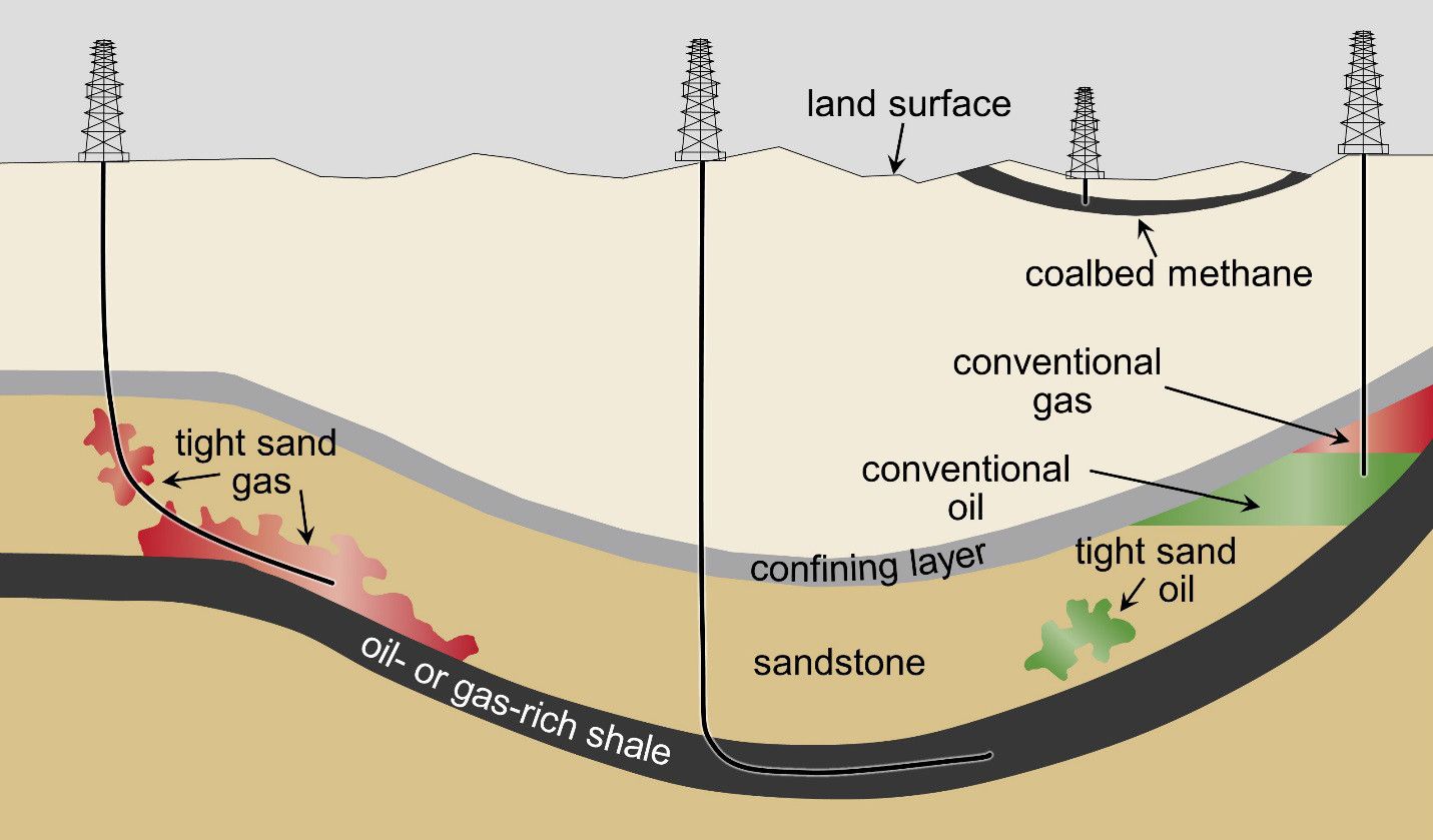
Schematic cross-section of general types of oil and gas resources. The figure also shows production wells used in hydraulic fracturing by unknown US Government employee – U.S. EPA. Assessment of the Potential Impacts of Hydraulic Fracturing for Oil and Gas on Drinking Water Resources (External Review Draft). U.S. Environmental Protection Agency, Washington, DC, EPA/600/R-15/047, 2015.. Licensed under Public Domain via Commons.
For a reservoir to be productive, the cap rock must be intact and unaffected by fractures or faults which might allow the fluids to escape – something which is not guaranteed in an area prone to earthquakes as is the Po Plain.
Mucciarelli et al. highlight that earthquakes of M 5.5 and above have the potential to cause movement on existing faults leading to new fractures, as well slip on existing faults, thus damaging cap rocks and rendering some reservoirs in the region unproductive as the hydrocarbons would be free to escape. Their argument is strengthened by the finding that a number of the sterile wells they identified cluster around the faults which caused the 2012 earthquakes, while productive wells are found a few kilometres distance away.
What the findings mean for prospective oil and gas fields
Through detailed statistical analysis, the researchers were able to define the characteristics of the productive and sterile areas in greater detail. They found that broader anticlines were less likely to be structurally sound as they were formed by wider, deeper and longer faults which in turn, could be the source of earthquakes. A cluster of unproductive wells would identify such regions during prospecting stages. Conversely, areas of productive wells identify areas unable to generate large earthquakes which would threaten the integrity of the reservoirs. Typically, these would also coincide with smaller anticlines.
The results have implications, not only for the oil and gas industry, but also for underground storage facilities. A CH4 storage facility was being built in an oil depleted reservoir right above the source of one of the May 2012 earthquakes. The research presented in the paper, combined with results from an earlier study by Evans in 2008, show that preference should be given to depleted gas reservoirs over depleted oil and aquifer reservoirs, when designing a gas storage facility in tectonically active areas.
The authors acknowledge that the Po Plain was an ideal case study in which to test their hypothesis. Study of other hydrocarbon producing regions, such as California, North Africa and the Middle East, is now required to fully validate the findings.
References
Evans, D.J.: An appraisal of underground gas storage technologies and incidents, for the development of risk assessment methodology, Prepared by the British Geological Survey for the Health and Safety Executive 2008, RR605 Research Report, 264 ++ tables, figures and appendix, available at: http://www.hse.gov.uk/research/rrpdf/rr605.pdf, 2008.
Mucciarelli, M., Donda, F., and Valensise, G.: Earthquakes and depleted gas reservoirs: which comes first?, Nat. Hazards Earth Syst. Sci., 15, 2201-2208, doi:10.5194/nhess-15-2201-2015, 2015.
Vannoli. P., Burrato, P., and Valensise, G.: The Seismotectonics of the Po Plain (Northern Italy): Tectonic Diversity in a Blind Faulting Domain, Pure Appl. Geophys., 172, 1105-1142, doi:10.1007/s00024-014-0873-0, 2015.

