At the beginning of March, just over a month ago, sea ice in the Arctic reached its annual maximum extent. As currently all media attention is focused on other news, you might have missed that, once again, this maximum fell below the 1981 to 2010 average maximum extent. When reading headlines about such sea-ice facts, you may have been confused by the seemingly interchangeable use of “sea-ice extent” and “sea-ice area” in different media and scientific outlets. Did you ever wonder if there is a difference between these two terms? Surprise: Yes there is! Read more to find it out…
A matter of definitions
Sea-ice area and sea-ice extent aim to describe a similar quantity, i.e. the area of ocean covered by sea ice in the polar regions. Although both approaches rely on the concept of dividing a region into grid cells, they result in a different value to express the sea-ice coverage.
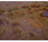
Sea-ice area is a more quantitative way of describing sea-ice coverage (see Fig. 2, purple). To calculate sea-ice area, we use the “sea-ice concentration”, i.e. the percentage of each grid cell covered by ice. We multiply the sea-ice concentration by the area of the grid cell, which results in the sea-ice area for this grid cell. The Arctic (or Antarctic) sea-ice area is the sum of the sea-ice areas of all grid cells.
Sea-ice extent is a different way of estimating sea-ice coverage (see Fig. 2, red). To calculate sea-ice extent, we also use the sea-ice concentration. However, instead of computing the area directly, the grid cells are divided into two categories based on a chosen threshold for the sea-ice concentration: grid cells with a sea-ice concentration exceeding this threshold are defined as “ice-covered”, while grid cells with a sea-ice concentration below this threshold are defined as “not ice-covered”. Finally, to calculate the total Arctic (or Antarctic) sea-ice extent at a given time, the whole area of the ice-covered grid cells is added together.
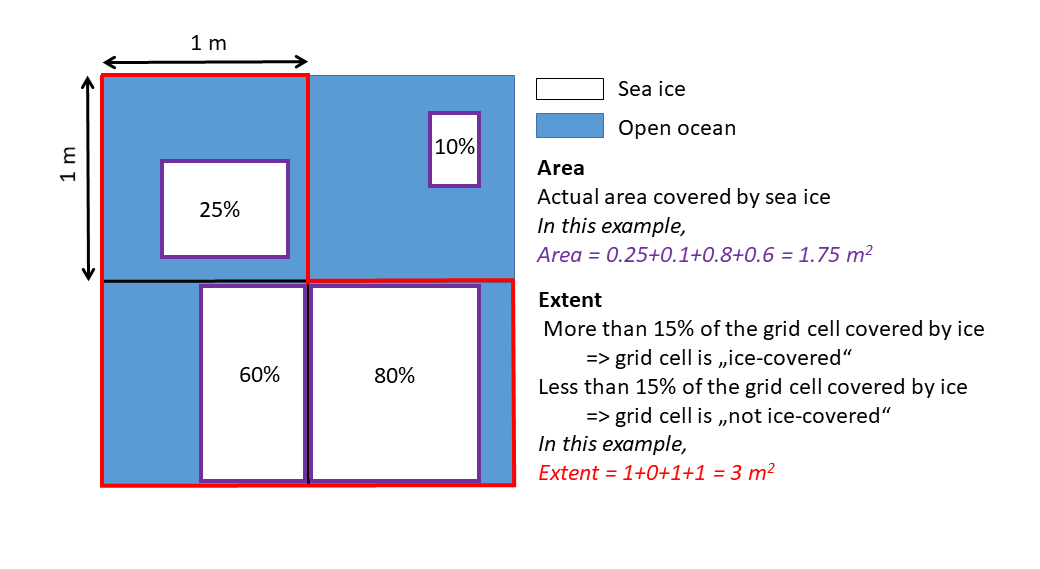
Fig. 2: Schematic illustrating the difference in computing the sea-ice area (purple) and the sea-ice extent (red) using four grid cells [Credit: C. Burgard].
The threshold commonly used by organisations making estimates of sea-ice extent is 15% of sea-ice concentration. The National Snow and Ice Data Centre (NSIDC), for example, uses 15% for their Sea Ice Index, an index on which most sea-ice statistics quoted in the media are based on! Why 15%? Well, estimates of sea-ice extent in the past using this 15% threshold have been found to match well with other forms of observations, e.g. airborne measurements from planes.
Choose your “side”
The use of sea-ice area (rather than extent) might seem more intuitive and precise for understanding the long-term evolution of sea ice in polar regions and its relationship with other climatic variables. This is why climate modellers often prefer to use it. However, modellers have an unfair advantage: the climate simulations they use provide clearly-defined grid cells and sea-ice concentration.
When monitoring sea ice by satellite, the ocean is not divided into clearly-defined grid cells and it is not always straightforward to discriminate between open ocean and sea ice! Read more in this previous post about these issues. This is why sea-ice extent is often preferred in the satellite community.
In other words…
To help get your head around this, let’s finish on an Easter metaphor…
Imagine you are frying your Easter egg sunny side up. Let’s say that this egg is a grid cell, that the yolk is equivalent to open ocean and the white is equivalent to sea ice. The sea-ice area would be only the area of the egg white, while the sea-ice extent would be the area of both egg white and egg yolk (because there is more than 15% egg white). So, probably, we could also call it sea-ice [eggs]tent… 😉
Further reading
- NSIDC FAQ – What is the difference between sea ice area and extent?
- NSIDC Sea-Ice Terminology
- NSIDC article – “No record-breaker maximum” from March 24th, 2020
- Cavalieri, D. J., Crawford, J. P., Drinkwater, M. R., Eppler, D. T., Farmer, L. D., Jentz, R. R., & Wackerman, C. C. (1991): Aircraft active and passive microwave validation of sea ice concentration from the Defense Meteorological Satellite Program Special Sensor Microwave Imager. Journal of Geophysical Research: Oceans, 96(C12), p. 21989-22008.
- Image of the Week – Of comparing oranges and apples in the sea-ice context
Edited by Jenny Arthur