If we look at Mars today, we’ll see a cold, dusty desert, but peel back the surface geology, and the planet tells quite a different story! Networked river valleys, ancient deltaic fans, carved impact crater lakes, and potential palaeoshorelines all point to a warm and active past during the Noachian and early Hesperian epochs, circa 3.7 to 4.1 billion years ago. For decades, planetary scientists have wrestled with an important question: if liquid water once flowed across Mars in the past, where did it go, how did it connect, and where did it accumulate?
Simulating this on a global scale has, historically, been a nightmare. Mars is pockmarked with over 385,000 impact craters, creating millions of natural basins that trap water. Standard Earth-based hydrological models either operate at too low a resolution, freeze oceans as static boundaries, or collapse when trying to compute millions of overflowing crater lakes across a high-resolution planetary grid.
In a groundbreaking paper published in the European Geosciences Union open-access journal Geoscientific Model Development, lead author Alexandre Gauvain and a team of scientists from the Laboratoire de Météorologie Dynamique and partner institutions have provided us with a solution: a global hydrological model designed to simulate surface water reservoirs across an entire planet.
How to build a supercharged hydrological engine…
To model planetary surface water without proscribing fixed coastlines or destroying supercomputers with endless fluid-dynamics calculations, Gauvain and his team adopted a novel computational strategy based on a depression hierarchy graph and a fill-spill-merge algorithm.
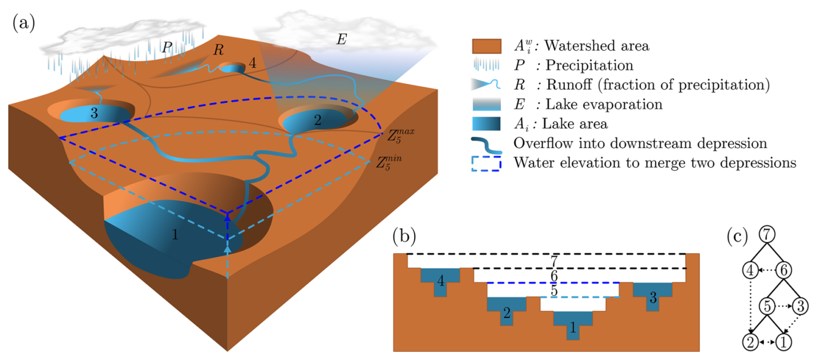
Figure 1: Representation of the water cycle on a conceptual topography with 4 leaf depressions. Source: https://gmd.copernicus.org/articles/19/6909/2026/
The core concept relies on straightforward terrain physics; water flows down the steepest path until it meets an unfilled topographic bowl. As water fills this bowl, it forms a lake. Once the lake reaches its spillover point, it overflows into downstream basins or merges with adjacent lakes to create a larger meta-depression. To make this framework run at planetary scale over millions of years, the authors built a massive, pre-computed hydrological database using high-resolution topographic data from the Mars Orbiter Laser Altimeter, measuring roughly 463 meters per pixel at the equator.
Instead of computing lake surface areas and elevations cell-by-cell at every single time step, the team pre-calculated lookup tables linking three variables for every basin: lake volume, lake surface area, and lake elevation. This database contains approximately twelve million depressions, split between almost six million individual crater or pit depressions and six million merged meta-depressions! (I know, crazy, right?)
By interpolating values from pre-computed tables rather than recalculating terrain geometry on the fly, the team cut the computation time for evaluating over two million active lakes from almost two hours down to just four point seven five seconds (a speedup factor of over one thousand four hundred times)!
The researchers ran forty-eight global simulations to equilibrium under controlled climate scenarios to test how water redistributes across Mars. They varied the global equivalent layer of water from one meter to one thousand meters if spread evenly across the planetary surface. They also tested evaporation rates ranging from one centimeter to ten meters per year, alongside various initial water distributions to determine whether starting conditions influenced the long-term equilibrium. Water balance in each active lake was updated dynamically at each time step by balancing local precipitation across the entire watershed against surface evaporation from the lake surface itself.
From crater lakes to Earth-sized mega-rivers!
The simulation outputs provided quantitative maps of ancient Martian lakes, seas, and river networks across various climate and water inventory settings. Remarkably, regardless of where the initial water was placed, whether spread uniformly across the planet or dumped entirely into a single impact basin, every simulation converged to the exact same steady-state water distribution for a given global water volume.
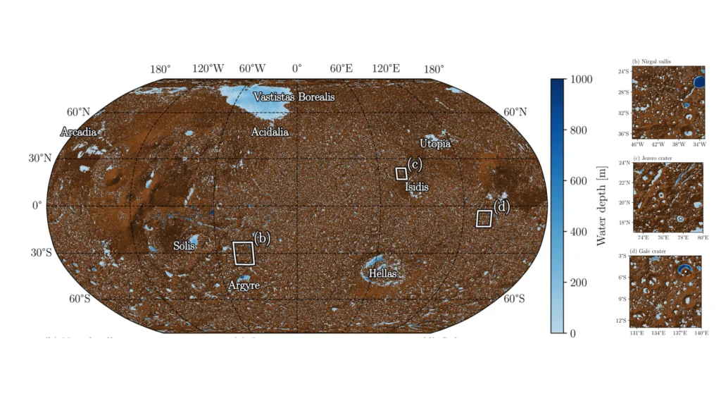
At very low water inventories, water remains trapped locally inside cratered southern terrain with minimal planetary runoff. However, between one meter and ten meters of global water equivalent, a critical threshold is -inevitably- crossed. Lakes in the mid-latitudes begin overflowing and transferring water northward to form a contiguous Northern Ocean. At ten meters, about twenty percent of all planetary water concentrates in the northern lowlands. By one hundred meters, an expansive Northern Ocean covers the northern plains, storing half of the planet’s surface water, while major southern basins like Hellas and Argyre store another twenty percent. At one thousand meters, a massive planetary ocean dominates the northern hemisphere, holding three-quarters of all surface water on Mars.
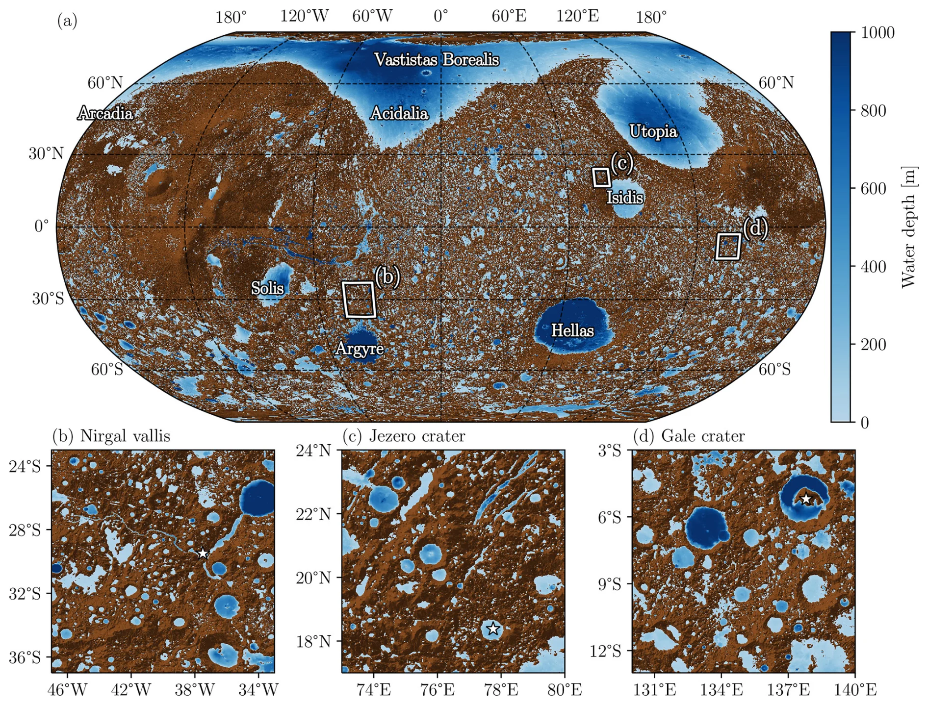
Figure 6 from paper: Distribution of water reservoirs (blue areas) at steady state with a Global Equivalent Layer (GEL) equal to 100 m. The color bar represents the water depth. The brown shaded areas represent the areas where the water cannot be accumulated. The white squares are zoomed areas on Nirgal Vallis’ watershed (b), Jezero’ watershed (c) and Gale’ watershed (d). The white stars localized the Nirgal Vallis outlet (b), Jezero crater (c) and Gale crater (d).
By tracking overflow fluxes across spillway points, the model identified four primary trunk river networks that funneled highland runoff directly into the Northern Ocean. The largest simulated river network, draining the Tharsis and Olympus Mons regions toward Marte Vallis, produced a steady-state discharge of approximately sixty-six thousand cubic meters per second. For scale, that is significantly larger than the modern Congo River, which averages around forty-one thousand cubic meters per second, or the Orinoco River at thirty-two thousand. A second major network through Simud and Lobo Valles drained Valles Marineris with flows reaching nearly thirty thousand cubic meters per second.
Zooming in on specific landing sites, the global model successfully captured localized lake fill-and-spill dynamics. At Jezero Crater, the landing site of NASA’s Perseverance rover, the simulation revealed two converging northern and northeastern river channels delivering inflows of roughly fifty cubic meters per second each. At Gale Crater, explored by the Curiosity rover, the model simulated a combined river system feeding over two hundred and forty cubic meters per second into the crater lake.
Finally, when the authors ran the model on a reconstructed ancient topography that accounts for True Polar Wander, the shift in Mars’ rotational axis caused by the volcanic growth of the massive Tharsis rise, the water distribution changed radically. Because ancient pre-wander topography lacked the modern northern basin slope and present-day Tharsis configuration, the massive Northern Ocean shrank, and water shifted toward equatorial regions and Noachian highlands. This highlights that reconstructing ancient crustal elevation is just as critical as predicting ancient atmospheric climate.
Between early Mars and exoplanet hydrology
This framework is far more than an academic exercise in mapping extinct lakes; it bridges a massive gap in planetary science. Until now, three-dimensional Global Climate Models of early Mars had to ‘guess’ where oceans or lakes were located or treat water bodies as static boundaries. The Gauvain model acts as a fast, mass-conserving module that can be coupled directly with atmospheric climate models into a comprehensive Planetary Evolution Model. This will allow scientists to simulate real-time climate-hydrology feedbacks, such as how evaporating lakes feed localised rainfall, which in turn fills river networks over orbital timescales of hundreds of thousands to millions of years.
When producing explicit maps of river runoff and lake elevations, the model also gives geoscientists a quantitative tool to test against physical observations on Mars. They can now compare simulated river discharges directly against sediment transport estimates from preserved deltas, or check whether predicted lake levels align with detected phyllosilicate and hydrated sulfate mineral deposits mapped by orbiting spacecraft. In addition, while applied to Mars in this study, the algorithms published in this study are planetary-agnostic. This database-driven framework can be adapted to study liquid methane dynamic lakes on Saturn’s moon Titan, ancient surface water on Venus, or climate states on newly discovered rocky exoplanets.
Gauvain and colleagues have built a scalable, physically consistent, and computationally light framework capable of reconstructing how surface water moves across an entire world. This model brings us one step closer to solving the mystery of Mars’ ancient climate, and understanding how terrestrial planets transform from water worlds into frozen deserts.