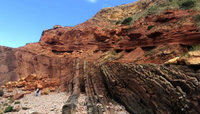
It is not unusual to observe abrupt contacts between two, seemingly, contiguous rock layers, such as the one featured in today’s featured image. This type of contact is called an unconformity and marks two very distinct times periods, where the rocks formed under very different conditions.
Telheiro Beach is located at the western tip of the Algarve; Portugal’s southernmost mainland region and the most touristic too.
The area, famous for its famous rocky beaches and great seefood, shows a spectacular Variscan unconformity between the highly-folded greywackes and shales of the Brejeira Formation (Moscovian-Carboniferous) and the horizontally placed red sandstones and mudstones of the Group Grés de Silves (of Late Triassic age: 237 and 201.3 million years old). There is a hiatus of about 100 million years between the two formations.
The Variscan period ranges from 370 million to 290 million year ago and is named after the formation of a mountain belt which extends across western Europe, as a result of the collision between Africa and the North American–North European continents.
The imposing sea cliffs produce a privileged place to observe the end of the Variscan Cycle and the beginning of the Alpine Cycle.
It is possible to visit the outcrop on foot, from the top of the cliffs to the beach, although the path is of high degree of difficulty. When going down to the beach one can begin to visualise the typical lithologies of the Grés de Silves. Toward its top you can see red to green Mudstones (dominant) intercalated with rare dolomites and immediately above the unconformity plane it is possible to observe the red sandstone with cross stratification. The highly-folded turbidites (a type of sediment gravity flow responsible for distributing vast amounts of clastic sediment into the deep ocean) of the Brejeira Formation are located below the unconformity.
The folds feature chevron geometries (where the rocks have well behaved layers, with straight limbs and sharp hinges, so that they look like sharp Vs). The folding is the result of the final deformation phase of the Variscan compression.
The beds of sedimentary rocks show sedimentary structures attributed to sedimentation in a turbidic environment (turbititic currents), namely the Bouma sequence and sole marks like flute, groove and load casts.
By André Cortesão, Environmental Engineer and Geoscientist collaborator of the University of Coimbra Geosciences Centre
Imaggeo is the EGU’s online open access geosciences image repository. All geoscientists (and others) can submit their photographs and videos to this repository and, since it is open access, these images can be used for free by scientists for their presentations or publications, by educators and the general public, and some images can even be used freely for commercial purposes. Photographers also retain full rights of use, as Imaggeo images are licensed and distributed by the EGU under a Creative Commons licence. Submit your photos at http://imaggeo.egu.eu/upload/

Chris Clemmons
Does someone have a cross section or a stratigraphic column done for this? I would love to share this as an example for my Geology students, as it is such an amazing example of angular unconformity.
Thanks!
Vox
I found this
https://www.researchgate.net/figure/Schematic-geology-of-the-Telheiro-beach-section-Adapted-from-Caroca-Dias-2001_fig10_289130086